- Bexley
-
Coordinates: 51°26′28″N 0°08′56″E / 51.441°N 0.149°E
Bexley 
 Bexley
Bexley shown within Greater LondonOS grid reference TQ465755 London borough Bexley Ceremonial county Greater London Region London Country England Sovereign state United Kingdom Post town BEXLEY Postcode district DA5 Dialling code 020 / 01322 Police Metropolitan Fire London Ambulance London EU Parliament London UK Parliament Old Bexley & Sidcup London Assembly Bexley and Bromley List of places: UK • England • London Bexley is an area of South East London in the London Borough of Bexley, London, England. It is located on the banks of the River Cray south of the Roman Road, Watling Street. There are two parts to the town - Old Bexley, still with the appearance of a village (and often referred to locally as "Bexley Village"), and more recent suburban sprawl that blends into the surroundings (which include Albany Park, Lamorbey, Bladindon, Blendon, and Bexleyheath). It is the suburban area that is now the main town centre of the borough, rather than Old Bexley. Bexley's Old Heath between Welling and Crayford now contains the council's main administrative offices and council chamber as well as suburban housing.
Contents
Landmarks
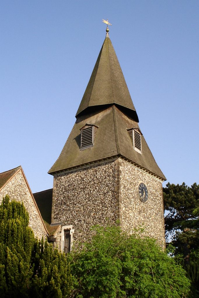
The main landmark in Bexley is the Anglican St. Mary's Church which gives its name to the London Borough of Bexley electoral ward containing the village. The church's most distinctive feature is probably the unusual spire which resembles an octagonal cone balanced precariously on top of a truncated pyramid.
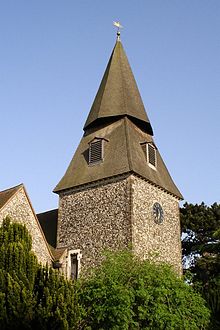 The distinctive spire of St. Mary's Church
Architecture
Hall Place is a former stately home, beside the River Cray on the Bourne Road out of Bexley towards Crayford. It lies to the north of Bexley at the foot of the road (Gravel Hill) up onto Bexley Heath (now covered in the modern day town of Bexleyheath). The house is unusual in that its two halves are built in highly contrasting architectural styles with little attempt at harmonizing them.
The house and grounds are now owned by the London Borough of Bexley, and are open to the public. The gardens include a topiary display of traditional heraldic figures. Three walking routes pass Hall Place, the local council-sponsored Shuttle River Way and Cray River Way and the Mayor of London's "London LOOP" walk, which, shortly after its start at Erith, follows the Cray River Way from Crayford to Foots Cray.
Danson House and the surrounding Danson Park in Welling are two of the main popular attractions in the London Borough of Bexley.
One of London's finest architectural families in the 19th century came from Bexley: the Shaws. John Shaw (1776–1832) worked on Lamorbey Park and was a well known architect in Kent and London, being one of the first designers of semi-detached housing in the capital. He is buried at St. Mary's Church; his son, John Shaw Jr, lived in nearby Crayford for a short time and owned a villa which was demolished in the early 20th century.
Red House the only house commissioned, created and lived in by William Morris, founder of the Arts and Crafts movement, Red House is a building of extraordinary architectural and social significance. When it was completed in 1860, it was described by Edward Burne-Jones as 'the beautifullest place on earth'. The house has been acquired by the National Trust and is open to the public, the house is not fully furnished, but the original features and furniture by Morris and Philip Webb, stained glass and paintings by Burne-Jones, the bold architecture and a garden designed to 'clothe the house are still available to view.
History
Bexley was an ancient parish of Kent, in the Diocese of Rochester, and under the Local Government Act 1894 formed part of Bexley Urban District. The urban district gained further status in 1935 as a municipal borough. Kent County Council formed the second tier of local government during that time. In 1965, London County Council was abolished and replaced by Greater London Council, with an expanded administrative area that took in the metropolitan parts of the Home Counties. Bexley Municipal Borough, Erith Municipal Borough, Crayford Urban District Council and Chislehurst & Sidcup Urban District Council were merged (less areas of Chislehurst and Sidcup that became part of the new London Borough of Bromley) into a new London Borough of Bexley (or Bexley London Borough, as the council likes to style itself).
Education
- For education in Bexley see the main London Borough of Bexley article
Local schools include Beths Grammar School - formerly the Bexley & Erith Technical High School, Hurst Primary School & Old Bexley C of E Primary School.
The following Schools have an 11+ selection test:
- Bexley Grammar School
- Beths Grammar School
- Chislehurst and Sidcup Grammar School
- Townley Grammar School
Amenities
- Holiday Inn (developed from the Black Prince hotel)
- Old Bexley Library, Bourne Road, Bexley
- Old Dartfordians' War Memorial clubhouse, Bourne Road (home to the DA5 Club)
Places of worship
- Albany Park Baptist Church, Stansted Crescent, Bexley
- St Mary the Virgin Church, Manor Road, Bexley
- St John the Evangelist, Parkhill Road, Bexley
- St John Fisher Roman Catholic Church, Thanet Road, Bexley
- Strict Baptist Chapel, Bourne Road, Bexley
- United Reformed Church, Hurst Road, Bexley
- Our Lady of Angels
Transport and locale
Nearest places
Rail
Bexley railway station is on the Sidcup line with trains going to Charing Cross, Cannon Street and Dartford.
Nearest railway stations
Serves stations between London (Charing Cross, Waterloo, Cannon Street & London Bridge) and Gillingham
Buses
- 132 - Bexleyheath Shopping Centre and North Greenwich
- 229 - Thamesmead town centre and Sidcup Queen Mary's Hospital
- 269 - Bexleyheath Shopping Centre and Bromley North station
- 492 - Sidcup Station and Bluewater Shopping Centre
- B12 - Joydens Wood and Erith
Also two school routes pass through the village including:
London Buses route 601 - Thamesmead town centre and Wilmington Schools
London Buses route 669 - Thamesmead town centre and Cleeve Park School in Albany Park
Also a night route passes through the village:
London Buses route N21 - Trafalgar Square and Bexleyheath Shopping Centre
External links
- Albany Park Baptist Church website
- Bexley Council archives
- St. Mary's Bexley website
- Bexley website
- 1870 description
- Holiday Inn, Bexley
- Hall Place
- Finale of the opening night of the DA5 Club, 26th February 2010
- Bexley community website
- Bexley Council for Voluntary Youth Organisations (BCVYO) website
London Borough of Bexley Districts Abbey Wood · Albany Park · Barnehurst · Barnes Cray · Belvedere · Bexley · Bexleyheath · Blackfen · Crayford · Crook Log · Crossness · East Wickham · Erith · Falconwood · Foots Cray · Lamorbey · Lessness Heath · Longlands · North Cray · Northumberland Heath · Sidcup · Slade Green · Thamesmead · Upton · Welling · West Heath
Attractions Parks and open spaces Lesnes Abbey WoodsConstituencies Other topics People · Public art · SchoolsSection 1: London Outer Orbital Path Section 2: Erith Old Bexley Petts Wood Categories:- Districts of London
- Districts of Bexley
- Districts of London listed in the Domesday Book
- London Loop


Wikimedia Foundation. 2010.