- North Cray
-
Coordinates: 51°25′26″N 0°08′06″E / 51.424°N 0.135°E
North Cray 
 North Cray
North Cray shown within Greater LondonOS grid reference TQ487722 London borough Bexley Ceremonial county Greater London Region London Country England Sovereign state United Kingdom Post town SIDCUP Postcode district DA14 Dialling code 020 Police Metropolitan Fire London Ambulance London EU Parliament London UK Parliament Old Bexley and Sidcup London Assembly Bexley and Bromley List of places: UK • England • London North Cray is a place in the London Borough of Bexley, southeast London, England, 20 km (12 mi) east southeast of Charing Cross. It lies on the River Cray and is in the Cray Meadows electoral ward which also includes Foots Cray. The post town for North Cray is Sidcup and the postcode is DA14, close by to the north is DA5 post code in the post town of Bexley.
North Cray was previously a civil parish in the Hundred of Ruxley, Sutton-at-Hone Lathe. The settlement Ruxley had its own parish but it was abolished in 1557 and the area was absorbed into North Cray parish.[1][2] North Cray was within Kent up until the creation of Greater London in 1965. From 1894 to 1934 North Cray was within the Bromley Rural District, then it was in the Chislehurst and Sidcup Urban District from 1934 to 1965; then finally the London Borough of Bexley from 1965 which remains today.
References
London Borough of Bexley Districts Abbey Wood · Albany Park · Barnehurst · Barnes Cray · Belvedere · Bexley · Bexleyheath · Blackfen · Crayford · Crook Log · Crossness · East Wickham · Erith · Falconwood · Foots Cray · Lamorbey · Lessness Heath · Longlands · North Cray · Northumberland Heath · Sidcup · Slade Green · Thamesmead · Upton · Welling · West Heath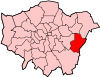
Attractions Parks and open spaces Lesnes Abbey WoodsConstituencies Other topics People · Public art · SchoolsCategories:- Districts of Bexley
- Districts of London
- Districts of London listed in the Domesday Book


Wikimedia Foundation. 2010.