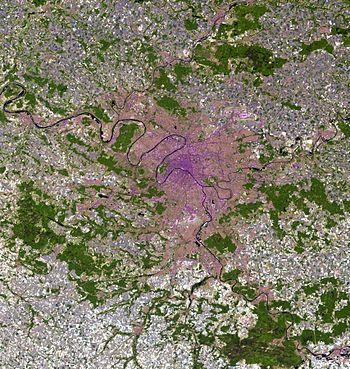
- Paris aire urbaine
-
"Petite Couronne" redirects here. For the French municipality in Upper Normandy, see Petit-Couronne."Grande Couronne" redirects here. For the French municipality in Upper Normandy, see Grand-Couronne.
The Paris aire urbaine (or "metropolitan area") is a statistical area that describes the reach of commuter movement to and from Paris and its surrounding urban area. The aire urbaine, a statistical area created by France's INSEE economy and census institution to describe suburban development around centres of urban growth, is composed of a couronne périurbaine (commuter belt) surrounding a more densely-constructed and densely-populated unité urbaine (or "urban area"). At present the Paris aire urbaine, with its 14,549 km², extends slightly beyond Paris' administrative Île-de-France administrative region, or "Paris Region".
Contents
Overview
The Paris aire urbaine expands at each population census due to the rapid population growth in the Paris area: new communes (municipalities) surrounding Paris become included in the aire urbaine when they meet the 40% commuter threshold required to be considered part of the aire urbaine. At the 1968 census, the earliest date for which population figures were retrospectively computed for French aire urbaines, the Paris aire urbaine had 9 872 000 inhabitants in an area that only encompassed central Île-de-France. At the 1999 census the Paris aire urbaine was by then slightly larger than Île-de-France and had 11,174,743 inhabitants. Its population is now estimated to be nearly 12 million in its 1999 limits, and this number will change again upon the INSEE publication of the 2006 population census.
Petite Couronne
Not to be confused with Petit-Couronne. Locator map showing the municipalities in which the Petite Couronne is divided. Paris is divided into its 20 arrondissements
The Petite Couronne[1] (Little Crown, i.e. Inner Ring) is the hub of the urban agglomeration of Paris. It is formed by the 3 departments of Île-de-France bordering with the French capital and forming a geographical crown around it. The departments, until 1968 part of the disbanded Seine department, are Hauts-de-Seine, Seine-Saint-Denis and Val-de-Marne. The most populated towns of the Petite Couronne are Boulogne-Billancourt, Montreuil, Saint-Denis, Nanterre and Créteil.
The table below shows some statistical informations about the area including Paris:
Department Area (km²) Population Municipalities  Paris (75)105.42,193,031[2]1 (Paris)
 Hauts-de-Seine (92)1761,536,100[3]
 Seine-Saint-Denis (93)2361,502,340[3]
 Val-de-Marne (94)2451,298,340[3]
Petite Couronne 6574,336,780123Paris + Petite Couronne 762.46,529,811124Grande Couronne
Not to be confused with Grand-Couronne.The Grande Couronne[4] (Greater Crown, i.e. Outer Ring) includes the towns of the metropolitan area part of the other 4 departments of Île-de-France not bordering with Paris. They are Seine-et-Marne (77), Yvelines (78), Essonne (91) and Val-d'Oise (95). The latter three departments formed the Seine-et-Oise department until this was disbanded in 1968. The city of Versailles is part of this area.
See also
- Grand Paris
- Metropolitan Areas of France
References
- ^ (French) CIG "Petite Couronne" website (Centre Interdépartemental de Gestion)
- ^ (French) INSEE. "Commune : Paris (75056) – Thème : Évolution et structure de la population". http://www.recensement.insee.fr/chiffresCles.action?codeMessage=5&zoneSearchField=PARIS&codeZone=75056-COM&idTheme=3&rechercher=Rechercher. Retrieved 2010-07-01.
- ^ a b c 2006 estimate
- ^ (French) CIG "Grande Couronne" website (Centre Interdépartemental de Gestion)
External links
- (French) Document about the functioning of Paris Metropolitan Area
- (French) Document about the extension of Paris Metropolitan Area
Categories:- Geography of France
- Geography of Paris
- Metropolitan areas of France
Wikimedia Foundation. 2010.


