- Tremblay-en-France
French commune|nomcommune=Tremblay-en-France
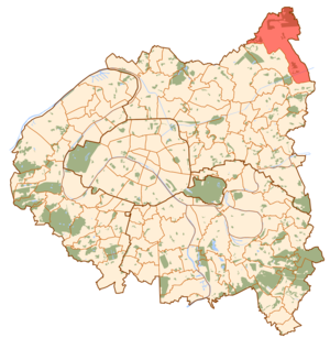
mapcaption=Paris and inner ring départements
lat_long=coord|48|57|00|N|2|34|20|E|region:FR_type:city| région=Île-de-France |département=Seine-Saint-Denis |arrondissement=Le Raincy|canton=|insee=|cp=|devise= |maire=|mandat=|intercomm="none as of 2005" |date-intercomm=|alt moy=|alt mini=|alt maxi=|km²=22.44|sans=
35,300
33,885
date-sans=Jan. 1, 2005 estimate)
(March 8, 1999 census|dens=1,573|date-dens=2005|Tremblay-en-France is a commune in the northeastern suburbs of
Paris ,France . It is located 19.5 km. (12.1 miles) from the center of Paris.More than one-quarter of
Charles de Gaulle International Airport lies on the territory of the commune of Tremblay-en-France, in particular terminals 2A, 2B, 2C, and 2D (the other terminals lie on the territory of other communes). It is the largest in area of the so-called "petite couronne" (inner ring) suburbs of Paris.History
Originally called Tremblay-lès-Gonesse, the commune was officially renamed Tremblay-en-France (meaning "Tremblay in the "pays de France", see
Roissy-en-France for an explanation) onAugust 20 ,1989 . [ [http://www.legifrance.gouv.fr/affichTexte.do?cidTexte=JORFTEXT000000885791 Décret du 16 août 1989 portant changement de nom de communes] fr icon]Transport
The part of
Charles de Gaulle International Airport that lies on the territory of the commune of Tremblay-en-France is served by two stations on Paris RER line P rer B: Aéroport Charles de Gaulle 1 andAéroport Charles de Gaulle 2 – TGV . This last station is an interchange station withTGV national rail lines.The inhabited area of Tremblay-en-France, however, is served by Vert-Galant station on Paris RER line P rer B. This station is located at the border between the commune of Tremblay-en-France and the commune of Villepinte, on the Villepinte side of the border.
Demography
DemogFR | 1793=824 | 1800=907 | 1806=927 | 1821=867 | 1831=862 | 1836=838 | 1841=822 | 1846=807 | 1851=753 | 1856=732 | 1861=743 | 1866=767 | 1872=735 | 1876=735 | 1881=720 | 1886=764 | 1891=720 | 1896=756 | 1901=763 | 1906=798 | 1911=837 | 1921=842 | 1926=2 095 | 1931=4 385 | 1936=6 181 | 1946=5 810 | 1954=9 510 | 1962=13 788 | 1968=18 482 | 1975=26 846 | 1982=29 644 | 1990=31 385 | 1999=33 885
sansdoublescomptes=1962References
External links
* [http://www.tremblay-en-france.fr/ Official website] fr icon

Wikimedia Foundation. 2010.