- Caernarfonshire
-
Not to be confused with Carmarthenshire.
Caernarfonshire
Welsh: Sir GaernarfonMotto: Cadernid Gwynedd (The strength of Gwynedd) 
Location of Caernarfonshire in WalesGeography 1831 area 370,273 acres (1,498.44 km2) 1911 area 365,986 acres (1,481.09 km2) 1961 area 364,108 acres (1,473.49 km2) HQ Caernarfon Chapman code CAE History Created 1284 Abolished 1974 Succeeded by Gwynedd Demography 1831 population
- 1831 density66,448[1]
0.2/acre1911 population
- 1911 density125,043
0.3/acre1961 population
- 1961 density121,767
0.3/acrePolitics Governance Carnarvonshire County Council (1889 - 1926)
Caernarvonshire County Council (1926-1974)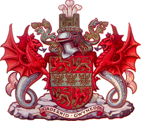
Coat of arms of Caernarvonshire County CouncilCaernarfonshire (Welsh: Sir Gaernarfon), historically spelled as Caernarvonshire or Carnarvonshire in English during its existence, was one of the thirteen historic counties, a vice-county and a former administrative county of Wales.
The administrative county of Caernarvonshire was abolished under the Local Government Act 1972, becoming part of the new county of Gwynedd. The administrative entity of Caernarfonshire was very briefly revived in 1996, when the unitary area of Caernarfonshire and Merionethshire was created. It was, however, renamed Gwynedd almost immediately.[2][3]
Contents
Geography
The county is bounded to the north by the Irish Sea, to the east by Denbighshire, to the south by Cardigan Bay and Merionethshire, and to the west by Caernarfon Bay and the Menai Strait, separating it from Anglesey.
The county has a largely mountainous surface. A large part of the Snowdonian Range lies in the centre and south of the county, including Snowdon itself, the highest mountain in Wales at 1,085 m. The north-west of the county is formed by the Llŷn peninsula, with Bardsey Island lying off its western end. The north of the county, between the mountains and Menai Strait, is a nearly level plain. The east of the county is part of Vale of Conwy, with the River Conwy forming much of the eastern boundary. Llandudno and Creuddyn forms a small peninsula to the north-east across the Conwy estuary.[4]
The principal towns of the county are Bangor, Betws-y-Coed, Caernarfon, Conwy, Llandudno, Porthmadog and Pwllheli.
History
Creation
The county was originally created under the terms of the Statute of Rhuddlan in 1284 following Edward I of England's conquest of the Principality of Wales and included the cantrefi of: Llŷn, Arfon, Arllechwedd and the commote of Eifionydd (the northern portion of Dunoding).[5]
The county was divided into ten hundreds based on the existing Welsh commotes: Cymydmaen (anglicised as Commitmaen), Creuddyn, Dinllaen, Eifionydd (Evionydd), Cafflogion (Gaflogion), Llechwedd Isaf (...Isav), Llechwedd Uchaf (...Uchav), Nant Conwy (Nant-Conway), Is Gwyrfai (Isgorvai) and Uwch Gwyrfai (Uchgorvai).[4][6]
Nineteenth and twentieth centuries
During the 19th century the population increased steadily, from 46,000 in the 1801 census to 137,000 in the 1901 census (figures given for the registration county).[7]
Governance
Under the Local Government Act 1888, an elected Carnarvonshire County Council taking over functions from the county's quarter sessions. The administrative county covered by the county council had identical borders to the geographic county. The administrative county was formally renamed Caernarvonshire on July 1, 1926.[8]
The county contained five ancient boroughs. Three of these (Caernarfon, Conway and Pwllheli) were reformed in 1835 by the Municipal Corporations Act. Criccieth established a special body of commissioners in 1873.[9][10]
The remaining borough, the City of Bangor was not reformed until 1883.[11] Under the Public Health Act 1848 and the Local Government Act 1858 a number of towns were created Local Board Districts or Local Government Districts respectively, with local boards to govern their areas. Other towns became Improvement Commissioners' Districts by private act of parliament. In 1875 these, along with the municipal boroughs, became urban sanitary districts. At the same time the remainder of the county was divided into rural sanitary districts, some of which crossed county boundaries. The Local Government Act 1894 redesignated these as urban and rural districts. A county review order in 1934 made changes to the county's districts.[12]
Sanitary district 1875 - 1894 County district 1894 - 1934 Changes 1934 - 1974 City of Bangor (municipal borough) City of Bangor (municipal borough) Absorbed part of Ogwen RD 1934[12] Bangor RSD (part) Ogwen RD Lost territory to Bangor MB, Nant Conway RD 1934[12] Bethesda ICD (1854), LGD (1863)[13] Bethesda UD None Carnarvon municipal borough Renamed Caernarvon in 1926[8] None Carnarvon RSD (part) Gwyrfai RD Absorbed part of Glaslyn RD 1934[12] Conway municipal borough Conway municipal borough Absorbed part of Conway RD[12] Conway RSD Conway RD Abolished 1934[12] Criccieth ICD (1873) Criccieth UD Absorbed part of Glaslyn RD 1934[12] Festiniog RSD Glaslyn RD Abolished 1934[12] Llandudno ICD (1874)[14] Llandudno UD Absorbed part of Conway RD 1934[12] Llanfairfechan LGD (1872)[15] Llanfairfechan UD None Llanrwst RSD (part) Geirionydd RD Formed Nant Conway RD by amalgamation with parts of Conway RD, Ogwen RD[12] 1898: Bettws-y-Coed UD[16] None Penmaenmawr LGD (1866)[17] Penmaenmawr UD None Pwllheli municipal borough Pwllheli municipal borough None Pwllheli RSD Lleyn RD Absorbed part of Glaslyn RD 1934[12] Ynyscynhaiarn LBD (1858)[18] Ynyscynhaiarn UD
renamed Portmadoc UD 1915[19]
Absorbed part of Glaslyn RD 1934[12] The civil parish of Llysfaen was a detached exclave of the county. On April 1, 1923 Llysfaen was transferred to the county of Denbighshire.
Coat of arms
Caernarvonshire County Council received a grant of armorial bearings from the College of Arms in 1949. The shield was a combination of the arms of two great native Princes of Wales. The gold and red quarters bearing lions were the arms of Llewelyn the Last - now used as the arms of the Principality of Wales. Across this was placed a green fess or horizontal band, on which were three gold eagles, from the arms of Owain Gwynedd. According to the poet Michael Drayton, the eagles formed the device on the banner of the Caernarvonshire soldiers at the Battle of Agincourt. The crest above the shield was a generic castle, representing Caernarfon, Conwy and Criccieth Castles. Behind the castle was the badge of the heir apparent: three ostrich feathers. The supporters were Welsh dragons with fish tails to show that Caernarvonshire was a Welsh maritime county. The supporter stood on a compartment of rocks for the rugged coast and mountains of the county. The motto Cadernid Gwynedd was adopted by the county council. This was derived from the Mabinogion, and can be translated as "The Strength of Gwynedd".[20]
Abolition
Under the Local Government Act 1972 the administrative county of Caernarvonshire was abolished on April 1, 1974. Caernarvonshire was largely split between the three districts of Aberconwy, Arfon and Dwyfor, in the new county of Gwynedd (along with Merionethshire and Anglesey). Since the Local Government (Wales) Act 1994 came into force on April 1, 1996 the area of the former county has been divided between the unitary authorities of Gwynedd to the west and Conwy to the east.
Bibliography
- A.H. Dodd, The History of Caernarvonshire (Caernarfonshire Historical Society, 1968).
- John Jones, Enwau Lleoedd Sir Gaernarfon (Caernarfon, 1913). Origin and meanings of place names in the county.
Places of interest
- Ynys Enlli / Bardsey Island (grid reference SH1221);
- Caernarfon Castle (grid reference SH4762);
- Conwy Castle (grid reference SH7877);
- Criccieth Castle (grid reference SH4937);
- Great Orme Tramway (grid reference SH7883);
- Gwydir Castle, nr. Llanrwst (grid reference SH7961);
- Penrhyn Castle (grid reference SH6071);
- Swallow Falls, Betws-y-Coed (grid reference SH7657);
- Snowdon Mountain Railway, Llanberis (grid reference SH5859);
- Ty Mawr Wybrnant (grid reference SH7752).
References
- ^ Vision of Britain - 1831 Census
- ^ "The Porthmadog Harbour Revision Order 1998 Statutory Instrument 1998 No. 683". Office of Public Sector Information. 1998. http://www.opsi.gov.uk/si/si1998/19980683.htm. Retrieved 2008-07-27.
- ^ "The County of Gwynedd (Electoral Changes) Order 2002, Welsh Statutory Instrument 2002 No. 3274 (W.312)". Office of Public Sector Information. 2002. http://www.opsi.gov.uk/legislation/wales/wsi2002/20023274e.htm. Retrieved 2008-07-27.
- ^ a b Samuel Lewis (editor) (1849). "Carnarvonshire". A Topographical Dictionary of Wales. British History Online. http://www.british-history.ac.uk/report.aspx?compid=47810#s2. Retrieved 2008-07-27.
- ^ Waters, W. H., The Making of Caernarvonshire, Caernarvonshire Historical Society Transactions, 1942-43
- ^ John Bartholomew (1887). "Carnarvonshire". Gazeteer of the British Isles. Vision of Britain. http://www.visionofbritain.org.uk/gaztext_page.jsp?u_id=10134651&c_id=10001043. Retrieved 2008-07-27.
- ^ "Caernarfonshire". Vision of Britain. http://www.visionofbritain.org.uk/data_cube_table_page.jsp?data_theme=T_POP&data_cube=N_TPop&u_id=10107349&c_id=10001043&add=N. Retrieved 2008-07-27.
- ^ a b Census of England and Wales 1931, County Report, Caernarvonshire
- ^ London Gazette: no. 23923. p. 5706. 1872-11-26. Retrieved 2008-07-27.
- ^ "Criccieth Urban District Council, records". Access to Archives. The National Archives. http://www.nlw.org.uk/cgi-bin/anw/search2?coll_id=2752&inst_id=37&term=Criccieth%20%7C%20Wales. Retrieved 2008-07-27.
- ^ "Bangor Borough Council records". Access to Archives. The National Archives. http://www.nlw.org.uk/cgi-bin/anw/search2?coll_id=2727&inst_id=37&term=Deeds%20%7C%20Wales%20%7C%20Bangor. Retrieved 2008-07-27.
- ^ a b c d e f g h i j k l Census of Wales 1931, part 2
- ^ London Gazette: no. 22768. p. 4328. 1863-09-04. Retrieved 2008-07-27.
- ^ "Llandudno Urban District Council records". Access to Archives. The National Archives. http://www.nlw.org.uk/cgi-bin/anw/fulldesc_nofr?inst_id=46&coll_id=1860&expand=1860A. Retrieved 2008-07-27.
- ^ "Llanfairfechan Urban District Council records". Access to Archives. The National Archives. http://www.nlw.org.uk/cgi-bin/anw/fulldesc_nofr?inst_id=46&coll_id=1857&expand=. Retrieved 2008-07-27.
- ^ Census of England and Wales 1901, County Report, Carnarvonshire
- ^ "Penmaenmawr Urban District Council records". Access to Archives. The National Archives. http://www.nlw.org.uk/cgi-bin/anw/fulldesc_nofr?inst_id=46&coll_id=1858&expand=1858A. Retrieved 2008-07-27.
- ^ London Gazette: no. 22092. p. 550. 1858-02-04. Retrieved 2008-07-27.
- ^ Census of England and Wales 1921, County Report, Carnarvonshire
- ^ C Wilfrid Scott-Giles, Civic Heraldry of England and Wales, 2nd edition, London, 1953
See also
- List of Lord Lieutenants of Caernarvonshire
- List of High Sheriffs of Caernarvonshire
- Counties of Wales
- Unitary Authorities of Wales
Anglesey • Brecknockshire • Caernarfonshire • Carmarthenshire • Cardiganshire • Denbighshire • Flintshire • Glamorganshire • Merionethshire • Monmouthshire • Montgomeryshire • Pembrokeshire • Radnorshire
Categories:- Caernarfonshire
- History of Gwynedd
- Historic counties of Wales
- States and territories established in 1284

Wikimedia Foundation. 2010.