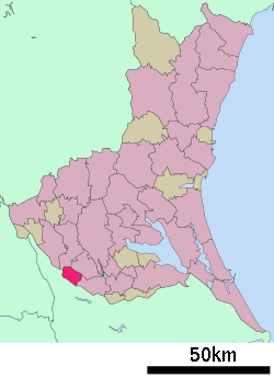
- Moriya, Ibaraki
-
Moriya
守谷市— City — Location of Moriya in Ibaraki Coordinates: 35°56′53″N 139°58′44″E / 35.94806°N 139.97889°ECoordinates: 35°56′53″N 139°58′44″E / 35.94806°N 139.97889°E Country Japan Region Kantō Prefecture Ibaraki Area - Total 35.63 km2 (13.8 sq mi) Population (May 1, 2011) - Total 62,716 - Density 1,760.2/km2 (4,558.9/sq mi) Time zone Japan Standard Time (UTC+9) Website City of Moriya Moriya (守谷市 Moriya-shi) is a city located in Ibaraki, Japan.
As of May 1, 2011, the city has an estimated population of 62,716, with a household number of 23,311, and the density of 1,760.20 persons per km². The total area is 35.63 km². The city was founded on February 2, 2002 when it was a town and left Kitasōma District.
The city is surrounded by three rivers, one of them the Tone, one of the longest rivers in Japan. In August 2005, the new Tsukuba Express train line connecting Akihabara, Tokyo to Tsukuba, Ibaraki was completed. Moriya is station #15 on this new line, approximately 35 minutes to central Tokyo.
This city is symbol of bird is Bambusicola thoracicus, symbol of tree is Pinus, and symbol of flower is Lilium auratum.[citation needed]
Moriya is a sister city to both Greeley, Colorado, USA and Mainburg, Germany.
Current mayor is Shinichi Aida, since December 1992.[citation needed]
External links
 Media related to Moriya, Ibaraki at Wikimedia Commons
- Official website (Japanese)
- Official website (English)
 Ibaraki Prefecture
Cities Bandō | Chikusei | Hitachi | Hitachinaka | Hitachiōmiya | Hitachiōta | Hokota | Inashiki | Ishioka | Itako | Jōsō | Kamisu | Kasama | Kashima | Kasumigaura | Kitaibaraki | Koga | Mito (capital) | Moriya | Naka | Namegata | Omitama | Ryūgasaki | Sakuragawa | Shimotsuma | Takahagi | Toride | Tsuchiura | Tsukuba | Tsukubamirai | Ushiku | Yūki
Higashiibaraki District Inashiki District Kitasōma District Kuji District Naka District Sashima District Yūki District 
This Ibaraki Prefecture location article is a stub. You can help Wikipedia by expanding it.


