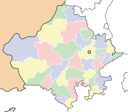
- Deshnoke
-
Deshnoke — city — Coordinates 27°47′28″N 73°20′28″E / 27.791°N 73.341°ECoordinates: 27°47′28″N 73°20′28″E / 27.791°N 73.341°E Country India State Rajasthan District(s) Bikaner Population 15,791 (2001[update]) Time zone IST (UTC+05:30) Area
• 265 metres (869 ft)
Deshnoke is a small town in the Bikaner district of Rajasthan, India, near the Pakistan border and about 30 km from Bikaner.
Deshnoke is famous for its 600 year old Karni Mata temple where rats are worshipped. Goddess Karni mata is worshiped by the royal family as well as general public of Bikaner and other parts of Rajasthan from old times.
Geography
Deshnoke is located at 27°47′26″N 73°20′27″E / 27.79056°N 73.34083°E. It has an average elevation of 265 metres (869 feet).
Demographics
As of 2001[update] India census,[1] Deshnoke had a population of 15,791. Males constitute 51% of the population and females 49%. Deshnoke has an average literacy rate of 51%, lower than the national average of 59.5%: male literacy is 60% and, female literacy is 41%. In Deshnoke, 19% of the population is under 6 years of age.
References
- ^ "Census of India 2001: Data from the 2001 Census, including cities, villages and towns (Provisional)". Census Commission of India. Archived from the original on 2004-06-16. http://web.archive.org/web/20040616075334/http://www.censusindia.net/results/town.php?stad=A&state5=999. Retrieved 2008-11-01.
Cities and towns in Bikaner district Bikaner Bikaner · Deshnoke · Dungargarh · Khajuwala · Loonkaransar · Udasar · Napasar · Nokha
Cities and towns
in other districtsAjmer · Alwar · Banswara · Baran · Barmer · Bharatpur · Bhilwara · Bundi · Chittorgarh · Churu · Dausa · Dholpur · Dungarpur · Hanumangarh · Jaipur · Jaisalmer · Jalore · Jhalawar · Jhunjhunu · Jodhpur · Karauli · Kota · Nagaur · Pali · Pratapgarh · Rajsamand · Sawai Madhopur · Sikar · Sirohi · Sri Ganganagar · Tonk · Udaipur
Categories:- Cities and towns in Bikaner district
- Rajasthan geography stubs
Wikimedia Foundation. 2010.


