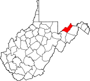
- Champwood, West Virginia
-
Champwood — Unincorporated community — Location within the state of West Virginia Coordinates: 39°26′36″N 78°49′9″W / 39.44333°N 78.81917°WCoordinates: 39°26′36″N 78°49′9″W / 39.44333°N 78.81917°W Country United States State West Virginia County Mineral Time zone Eastern (EST) (UTC-5) – Summer (DST) EDT (UTC-4) ZIP codes FIPS code GNIS feature ID Champwood is an unincorporated community on Patterson Creek in Mineral County, West Virginia, USA. It is part of the 'Cumberland, MD-WV Metropolitan Statistical Area'. Champwood lies along West Virginia Route 46.
Municipalities and communities of Mineral County, West Virginia City Towns Carpendale | Elk Garden | Piedmont | Ridgeley
CDPs Other
localitiesAntioch | Atlantic Hill | Barnum | Beryl | Blaine | Champwood | Claysville | Cross | Dans Run | Emoryville | Forge Hill | Fountain | Hampshire | Harrison | Hartmansville | Headsville | Keymont | Laurel Dale | Limestone | Markwood | Nethkin | New Creek | Oakmont | Patterson Creek | Reeses Mill | Ridgeville | Rocket Center | Russelldale | Short Gap | Skyline | Sulphur City | Wagoner
Categories:- Potomac Highlands geography stubs
- Populated places in Mineral County, West Virginia
- Unincorporated communities in West Virginia
Wikimedia Foundation. 2010.


