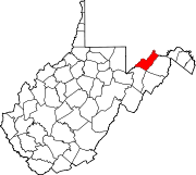
- Markwood, West Virginia
-
Markwood — Unincorporated community — Location within the state of West Virginia Coordinates: 39°20′7″N 78°57′50″W / 39.33528°N 78.96389°WCoordinates: 39°20′7″N 78°57′50″W / 39.33528°N 78.96389°W Country United States State West Virginia County Mineral Time zone Eastern (EST) (UTC-5) – Summer (DST) EDT (UTC-4) ZIP codes 26710 FIPS code GNIS feature ID Markwood is an unincorporated community located along U.S. Route 50/U.S. Route 220 (also known as the Northwestern Turnpike) in the Mill Creek Valley west of Burlington in Mineral County, West Virginia. The ZIP code for Markwood is 26710.
Historic sites
- Travelers Rest Travelers Rest is located on U.S Route 50 West of Burlington in Mineral County, West Virginia. It was built for the Wagon Trains going west. It would house the travelers in a Large Rock House, and feed and water the horses before going over the Mountains. Better known today as the "Stone House"
Mr. John T. McDowell (born 1870) and Mr. Luke Markwood, saw a need for a place of worship. Mr. Markwood donated the land upon which was built a Church and a School, therefore giving the community the name of Markwood.
Municipalities and communities of Mineral County, West Virginia City Towns Carpendale | Elk Garden | Piedmont | Ridgeley
CDPs Other
localitiesAntioch | Atlantic Hill | Barnum | Beryl | Blaine | Champwood | Claysville | Cross | Dans Run | Emoryville | Forge Hill | Fountain | Hampshire | Harrison | Hartmansville | Headsville | Keymont | Laurel Dale | Limestone | Markwood | Nethkin | New Creek | Oakmont | Patterson Creek | Reeses Mill | Ridgeville | Rocket Center | Russelldale | Short Gap | Skyline | Sulphur City | Wagoner
Categories:- Potomac Highlands geography stubs
- Populated places in Mineral County, West Virginia
- Unincorporated communities in West Virginia
- Northwestern Turnpike
Wikimedia Foundation. 2010.


