- Dans Run, West Virginia
-
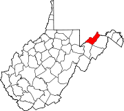
Dans Run — Unincorporated community — Location within the state of West Virginia Coordinates: 39°32′46″N 78°41′29″W / 39.54611°N 78.69139°WCoordinates: 39°32′46″N 78°41′29″W / 39.54611°N 78.69139°W Country United States State West Virginia County Mineral Time zone Eastern (EST) (UTC-5) – Summer (DST) EDT (UTC-4) ZIP codes FIPS code GNIS feature ID Dans Run is an unincorporated community in Mineral County, West Virginia. It is part of the Cumberland, MD-WV Metropolitan Statistical Area. Dans Run is located along the former Baltimore and Ohio Railroad (now CSX) at the confluence of Dans Run and the North Branch Potomac River.
Municipalities and communities of Mineral County, West Virginia City Towns Carpendale | Elk Garden | Piedmont | Ridgeley
CDPs Other
localitiesAntioch | Atlantic Hill | Barnum | Beryl | Blaine | Champwood | Claysville | Cross | Dans Run | Emoryville | Forge Hill | Fountain | Hampshire | Harrison | Hartmansville | Headsville | Keymont | Laurel Dale | Limestone | Markwood | Nethkin | New Creek | Oakmont | Patterson Creek | Reeses Mill | Ridgeville | Rocket Center | Russelldale | Short Gap | Skyline | Sulphur City | Wagoner
Categories:- Potomac Highlands geography stubs
- Populated places in Mineral County, West Virginia
- Unincorporated communities in West Virginia
- Baltimore and Ohio Railroad
- Populated places on the Potomac River
Wikimedia Foundation. 2010.


