- Mojave River
-
Mojave River  Mojave River at Afton Canyon, March 2010
Country  United States
State  California
Cities Hesperia, Victorville, Barstow Source Confluence of West Fork Mojave River and Deep Creek - location Mojave River Forks Reservoir, San Bernardino Mountains - elevation 2,986 ft (910 m) - coordinates 34°20′29″N 117°14′14″W / 34.34139°N 117.23722°W [1] Mouth Soda Lake - location Baker, Mojave Desert - elevation 935 ft (285 m) - coordinates 36°06′20″N 116°03′53″W / 36.10556°N 116.06472°W [1] Length 110 mi (177 km) Basin 4,580 sq mi (11,862 km2) [2] Discharge for Lower Narrows, near Victorville - average 65.7 cu ft/s (2 m3/s) [3] - max 70,600 cu ft/s (1,999 m3/s) - min 0 cu ft/s (0 m3/s)  Map of the Mojave River watershed
The Mojave River is an intermittent river in the eastern San Bernardino Mountains and Mojave Desert in San Bernardino County, California. The river is notable as most of its flow is underground, while its surface channels remain dry most of the time, with the exception of the headwaters and several bedrock gorges in the lower reaches.
Contents
Course
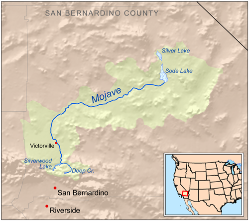
The river's source is in the San Bernardino Mountains, one of the Transverse Ranges, above Hesperia-San Bernardino. The West Fork of the Mojave flows into Silverwood Lake, formed by Cedar Springs Dam, which overflows in the Mojave River Forks Reserve area. On occasion, the lake releases water into the river.[citation needed] Downstream, Deep Creek meets the West Fork, forming the Mojave River immediately upstream of the Mojave River Dam, which provides flood control. Downstream of the dam, the Mojave River flows north and east, underground in most places, through Hesperia, Victorville, and Barstow.
Near its terminus, the Mojave River flows out onto a large inland delta called the Mojave River Wash at the western edge of Mojave National Preserve. During heavy flows, the river reaches Soda Lake near Baker at the north end of the Wash, and has reached Silver Lake, even further north, in historic times. For example, during the unusually wet winter of 2004–2005, the Mojave River flowed on the surface all the way to Silver Lake and filled both Soda and Silver Lakes to a depth of several feet.[4]
 Mojave River Dam Outlet
The water in the river is mostly underground. The channel at the surface remains dry most of the time, but extreme flooding is possible. For example, during a heavy El Niño in the Mojave Desert, rains caused the Mojave River to overflow onto overpassing bridges on 22 February 1993, the most damaged being on Bear Valley Road, where Victorville and Apple Valley are separated. The water comes to the surface only in areas with impermeable rock, such as the upper and lower narrows near Victorville and in the Afton Canyon area northeast of Barstow.
History
A desert branch of the Serrano Native Americans called the Vanyume or Beñemé, as Father Garcés called them, lived beyond and along much of the length of the Mojave River, from the east of Barstow to at least the Victorville region, and perhaps even farther upstream to the south, lived along the river for up to 8,000 years.[5] The Indian trail, later the immigrants' Mojave Road, paralleled the river from Soda Lake to the Cajon Pass. Native Americans used this trade route where water could easily be found enroute to the coast. Garcés explored up the length of the Mojave River in early 1776.[5] Jedediah Smith was the first American to travel overland to California by following the Mojave Indian Trail in 1826.
Later, the Old Spanish Trail and Salt Lake Trail (Mormon Trail) joined up with the river and Mojave Road near the present-day location of Daggett, where historic Camp Cady was located.
Afton Canyon Natural Area
The Afton Canyon Natural Area, managed by the Bureau of Land Management, is located 37 miles northeast of Barstow along Interstate 15 between the Afton Road and Basin Road exits. Afton Canyon is designated as an Area of Critical Environmental Concern to protect plant and wildlife habitat, and to preserve scenic values of the Mojave River's riparian area within the canyon.[6] The Rasor Off-Highway Vehicle Area boundary enforcement has begun to reverse the heavy off-road vehicles use and damage that occurred in the riverbed and canyon. Restoration projects are ongoing, and have already brought the river's "proper functioning condition" from a "non-functioning" to a "functioning at risk" status. The objectives of the ambitious restoration project are to control exotic plants, particularly the phreatophyte Saltcedar - Tamarix (primarily Tamarix ramosissima and T. parviflora), and restoring critical desert California native plant community "structural elements" for a functioning flora and fauna habitat.[7]
See also
- Category: Flora of the California desert regions
- Mojave National Preserve
- Category: Protected areas of the Mojave Desert
References
- ^ a b "Mojave River". Geographic Names Information System, U.S. Geological Survey. 1981-01-19. http://geonames.usgs.gov/pls/gnispublic/f?p=gnispq:3:::NO::P3_FID:272518. Retrieved 2011-07-13.
- ^ "Boundary Descriptions and Names of Regions, Subregions, Accounting Units and Cataloging Units". USGS.gov. http://water.usgs.gov/GIS/huc_name.html. Retrieved 2010-06-07.
- ^ "USGS Gage #10261500 on the Mojave River at Lower Narrows near Victorville, CA". National Water Information System. U.S. Geological Survey. 1970-present. http://nwis.waterdata.usgs.gov/nwis/monthly/?referred_module=sw&site_no=10261500&por_10261500_2=2207151,00060,2,1899-03,2010-10&format=html_table&date_format=YYYY-MM-DD&rdb_compression=file&submitted_form=parameter_selection_list. Retrieved 2011-07-13.
- ^ Eyewitness[dead link] at VVDailyPress.com
- ^ a b "Vanyume Indians". Digital-Desert: Mojave Desert. http://mojavedesert.net/vanyume-indians/. Retrieved 2011-01-30.
- ^ http://www.blm.gov/ca/st/en/fo/barstow/afton.html . accessed 6/20/2010 . BLM Public domain source]
- ^ http://www.blm.gov/ca/st/en/fo/barstow/sltcdr97pa1.html . accessed 6/20/2010 . BLM Public domain source
- Philip Stoffer (14 January 2004). "Changing Climates and Ancient Lakes" (.html). Desert Landforms and Surface Processes in the Mojave National Preserve and Vicinity. Open-File Report 2004-1007 (USGS, US Department of the Interior). http://pubs.usgs.gov/of/2004/1007/climates.html. Retrieved 2009-09-12.
- Philip Stoffer (14 January 2004). "Playas" (.html). Desert Landforms and Surface Processes in the Mojave National Preserve and Vicinity. Open-File Report 2004-1007 (USGS, US Department of the Interior). http://pubs.usgs.gov/of/2004/1007/playas.html. Retrieved 2009-09-12.
- Philip Stoffer (14 January 2004). "The Mojave River and Associated Lakes" (.html). Desert Landforms and Surface Processes in the Mojave National Preserve and Vicinity. Open-File Report 2004-1007 (USGS, US Department of the Interior). http://pubs.usgs.gov/of/2004/1007/river.html. Retrieved 2009-09-12.
External links
- Mojave River - Digital Desert
- The Mojave River and Associated Lakes
- Mojave River through the Victorville Narrows
- Official Afton Canyon Natural Area website
- Official Mojave National Preserve website
River morphology Large-scale features Alluvial rivers Meander • Meander cutoff • Point bar • Cut bank • Riffle • Stream pool • Braided river • Bar (river morphology) • Anabranch • River bifurcation • River channel migration • Oxbow lake • Floodplain • Riparian corridor • Avulsion (river) • Mouth bar • Thalweg • Channel patternBedrock river Bedforms Regional processes Mechanics Playfair's Law • Hack's law • Sediment transport • Water erosion • Deposition (geology) • Exner equationCategories:- Subterranean rivers
- Mojave Desert
- Mojave National Preserve
- Rivers of Southern California
- San Bernardino Mountains
- Rivers of San Bernardino County, California
- Rivers of Los Angeles County, California
- Natural history of the Mojave Desert


Wikimedia Foundation. 2010.