- Kents Hill, Monkston and Brinklow
-
Kents Hill, Monkston and Brinklow is a civil parish in Milton Keynes, Buckinghamshire, England.[1] It was formed in 2001 as part of a general parishing of the Borough. The population according to the 2001 census was 4,545.
The parish covers Kents Hill, Brinklow, Monkston, Monkston Park and Kingston. It is bounded by Chaffron Way, the Broughton Brook, Newport Road, Groveway, Brickhill Street, Standing Way, and the River Ouzel.
Contents
Kents Hill
The west side of this district contains part of the Open University campus (the buildings originally belonged to De Montfort University), the Accenture training centre and the Hilton Hotel. The rest of the district is residential , much of it overlooking a large recreational area. There is a local shop, a church, three parks and three 11-a-side football pitches on the estate. There is also a school which consists of a nursery and a first school.
Monkston and Monkston Park
This is primarily a residential district based around a large circular recreational area and a combined school.
Pre-history
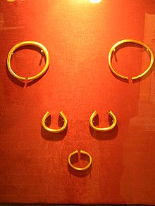
The area that was to become Milton Keynes was relatively rich: possibly the largest (by weight) hoard of Bronze Age jewellery ever found in Britain ("the Milton Keynes Hoard") was discovered in Monkston and consists of two late Bronze Age gold torcs and three gold bracelets.[2][3]
Kingston
Main article: Kingston, Milton KeynesThe Kingston district is primarily a manufacturing and distribution industries one [due to its proximity to Junctions 13 and 14 of the M1]. At its centre is a large retail complex, dominated by a Tesco hypermarket: this complex serves the eastern and south-eastern suburbs of Milton Keynes.
Brinklow
This is a relatively small warehousing and industrial district. It is dominated by the large Waitrose distribution centre.
References
- ^ Parishes in Milton Keynes - Milton Keynes Council.
- ^ British Museum: the Milton Keynes Hoard (now in collection of the British Museum, replicas are on display in the Milton Keynes Museum)
- ^ Needham, S (2002). "Milton Keynes, Buckinghamshire: Bronze Age gold hoard of two torcs and three bracelets in a pot". Treasure Annual Report 2000. Department of Culture, Media and Sport. pp. 13–15. http://www.ncmd.co.uk/docs/treasurereport2000.pdf. Retrieved 2010-07-26.
External links
- Housing in Kents Hill with photographs on MKweb
- Housing in Monkston – MKweb
Coordinates: 52°01′53″N 0°42′22″W / 52.0314°N 0.706°W
Civil parishes in Milton Keynes Astwood • Bletchley and Fenny Stratford • Bow Brickhill • Bradwell • Bradwell Abbey • Broughton • Calverton • Campbell Park • Castlethorpe • Central Milton Keynes • Chicheley • Clifton Reynes • Cold Brayfield • Emberton • Gayhurst • Great Linford • Hanslope • Hardmead • Haversham-cum-Little Linford • Kents Hill, Monkston and Brinklow • Lathbury • Lavendon • Little Brickhill • Loughton • Milton Keynes • Moulsoe • New Bradwell • Newport Pagnell • Newton Blossomville • North Crawley • Olney • Ravenstone • Shenley Brook End • Shenley Church End • Sherington • Simpson • Stantonbury • Stoke Goldington • Stony Stratford • Tyringham and Filgrave • Walton • Warrington • Wavendon • West Bletchley • Weston Underwood • Woburn Sands • Wolverton and Greenleys • Woughton
Categories:- Civil parishes in Milton Keynes Borough
- Milton Keynes
- Buckinghamshire geography stubs

Wikimedia Foundation. 2010.