- Rottnest Island
-
Rottnest Island
Western Australia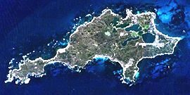
Rottnest Island from spacePopulation: 300 (up to 15,000 visitors at peak holiday periods)[1] Established: 1830s Postcode: 6161 Elevation: 46 m (151 ft) Area: 19 km² (7.3 sq mi) Time zone: AWST (UTC+8) Location: 19 km (12 mi) W of Fremantle LGA: A-class reserve administered by the Rottnest Island Authority State District: Fremantle Federal Division: Fremantle Mean max temp Mean min temp Annual rainfall 21.5 °C
71 °F14.9 °C
59 °F702.3 mm
27.6 inCoordinates: 32°00′07″S 115°31′01″E / 32.002°S 115.517°E
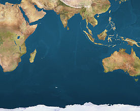
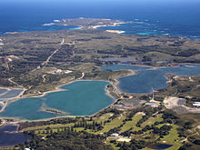
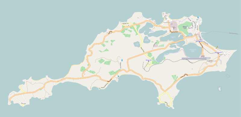
Rottnest Island is located 18 kilometres (11 mi) off the coast of Western Australia, near Fremantle. It is called Wadjemup by the Noongar people, meaning "place across the water". The island is 11 kilometres (6.8 mi) long, and 4.5 kilometres (2.8 mi) at its widest point with a total land area of 19 square kilometres (7.3 sq mi). It is classified as an A Class Reserve and is managed by the Rottnest Island Authority. No private ownership of land is allowed. It is antipodal to the island of Bermuda.
The Western Australian vernacular diminutive is "Rotto", or "Rottnest". It has been an important local holiday destination for over 50 years.
The island is administered by the Rottnest Island Authority, an agency of the Western Australian government, set up specifically for this purpose. The authority collects revenue by imposing a landing fee on all visitors to the island. In 2004, a Taskforce set up by the State Government made 103 recommendations aimed at achieving a sustainable future for Rottnest Island. In recent years, implementation of the recommendations has seen the majority of the RIA-administered accommodation refurbished or upgraded.
Contents
History
Pre-history
See also: Australian Aboriginal prehistoric sitesRottnest Island was inhabited by Aboriginal people until rising sea levels separated the island from the mainland of Western Australia approximately 7,000 years ago. The island features in Noongar Aboriginal mythology as Wadjemup, meaning 'Place across the water'.[2] Aboriginal artefacts on the island have been dated from 6,500 to more than 30,000 years ago.[3] However, recent evidence suggests human occupation significantly before 50,000, possibly as early as 70,000 BP.[4]
There were no people on the island when European exploration began in the 17th century, and the Aboriginal people on the mainland did not have boats that could make the crossing, so the island had probably been uninhabited for several thousand years.[5]
European exploration and settlement
The island was observed by various Dutch sailors from 1610, including Frederick de Houtman in 1619.[citation needed] The first Europeans known to land on the island were 13 Dutch sailors including Abraham Leeman from the Waeckende Boey who landed near Bathurst Point on 19 March 1658 while their ship was careened nearby. The ship had sailed from Batavia (Jakarta) in search of survivors of the missing Vergulde Draeck which was later found wrecked 80 km north near present day Ledge Point. Samuel Volkersenn, the skipper of the Waeckende Boey described the island in his journal:
In slightly under 32° S. Lat. there is a large island, at about 3 miles' distance from the mainland of the South-land; this island has high mountains, with a good deal of brushwood and many thornbushes, so that it is hard to go over; here certain animals are found, since we saw many excrements, and besides two seals and a wild cat, resembling a civet-cat, but with browner hair. This island is dangerous to touch at, owing to the rocky reefs which are level with the water and below the surface, almost along the whole length of the shore; between it and the mainland there are also numerous rocks and reefs, and slightly more to southward there is another small island.
This large island to which we have been unwilling to give a name, leaving this matter to the Honourable Lord Governor-General's pleasure, may be seen at 7 or 8 miles' distance out at sea in fine weather. I surmise that brackish or fresh water might be obtainable there, and likewise good firewood, but not without great trouble.[6]
In his 1681 chart the English captain John Daniel marked an island as Maiden's Isle, possibly referring to Rottnest. The name did not survive, however.
The island was given the name "Rattenest" (meaning "rat's nest" in the Dutch language) by the Dutch fleet captain Willem de Vlamingh on 29 December 1696. De Vlamingh described the eponymous indigenous marsupial, called a quokka, as a large rat.[7]
Other explorers who stopped at the island included members of the French expedition of Nicholas Baudin in the Naturaliste and the Geographe in 1801 (when he planted a flag and left a bottle with a letter[8]) and 1803, Phillip Parker King in 1822, and Captain James Stirling in 1827. Early visitors commonly reported that much of the island was heavily wooded, which is not the case today.[5]
In 1830, shortly after the establishment of the British Swan River Colony at nearby Fremantle, Robert Thomson settled on the island with his wife and seven children. Thomson developed pasture land west of Herschel Lake as well as salt harvesting and refining from the several salt lakes which was then exported to the mainland settlement. Salt was an important commodity before the advent of refrigeration.
Aboriginal prison
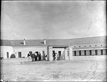
Ten Aboriginal prisoners were sent to Rottnest Island in August 1838. The Colonial Secretary announced in June 1839 that the island would become a penal establishment for Aboriginal people, and between 1838 and 1931, except for the period 1849 to 1855, Rottnest was used as an Aboriginal prison. A quadrangular shaped building was contructed in 1863-64 and generally referred to as "The Quod". It is used today for tourist accomodation.
It has been estimated that there may be as many as 369 Aboriginal graves on the island. Some 3,700 Aboriginal men and boys were imprisoned there.[citation needed]
Boys reformatory
A reformatory for boys was opened on 16 May 1881.[9]
In May 1898 two boys disappeared, apparently drowned, after escaping from the reformatory and stealing a dinghy.[10]
After twenty years of operation, the facility closed on 21 September 1901 when the remaining 14 inmates were transferred to an industrial school on the mainland. The superintendent during the entire period was John Watson.[11][12]
The reformatory buildings are now used as holiday accommodation as part of the Rottnest Lodge.[13]
Military history
Rottnest was the site of an internment camp in both World War I and World War II. In WWI it was mostly used for German and Austrian suspected enemy aliens, before being closed towards the end of the war due to poor living conditions. During WWII the camp was used exclusively for Italian enemy aliens. The camp was closed about halfway through the war, and its occupants were sent to various other internment and work camps on the mainland.[14]
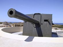
Also during World War II, two 9.2-inch guns were installed near the middle of the island at Oliver Hill, and two 6-inch guns installed at Bickley Point, for defence of the Fremantle port. The location of the island was seen as being important to the defence of the important port of Fremantle, the major base for the Allies in the Indian Ocean, as bombardment of any attacking ships could be made from the island before the ships would come into range of the port.
A light railway was built from the jetty at Kingstown Barracks on Thomson Bay, to transport materiel and munitions to the guns. The military fixtures including the barracks and railway became known as the "Rottnest Island Fortress".
After WWII the guns and infrastructure was decommissioned and parts of the railway removed. The 9.2-inch battery was however saved from disposal because the high cost of removing and shipping the guns to the mainland exceeded their value as scrap metal.
In the 1990s the gun emplacements and railway were extensively reconstructed and today a popular tourist activity includes tours over the guns and the tunnels with the journey to the battery being made on a purpose-built train.
Flora and fauna
Birds
Many coastal birds frequent Rottnest. These include the Pied Cormorant, Osprey, Pied Oystercatcher, Silver Gull, Crested Tern, Fairy Tern, Bridled Tern, Rock Parrot and the Reef Heron. The island salt lakes contain brine shrimp which support birds such as the Red-necked Avocet, Banded Stilt, Ruddy Turnstone, Curlew Sandpiper, Red-capped Dotterel, Australian Shelduck, Red-necked Stint, Grey Plover, White-fronted Chat, Caspian Tern and the Crested Tern.[15] Several pairs of Osprey nest at Rottnest each year; one nest at Salmon Point is estimated to be 70 years old. Introduced peafowl are often seen near the main settlement.
The island has been identified by BirdLife International as an Important Bird Area (IBA) because it supports important breeding populations of the Fairy Terns (200-300 breeding pairs), over 1% of the non-breeding population of Banded Stilts (with up to 20,000 birds) and regionally-significant numbers of Wedge-tailed Shearwaters and Red-necked Stints.[16]
Other animals
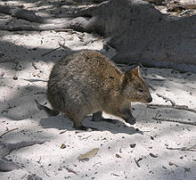 A Rottnest quokka
Rottnest is one of the few areas in the world where the quokka[17] can be found. This is largely due to the exclusion of introduced predators from the mainland.
Reptiles include dugite (Pseudonaja affinis), the Southern Blind Snake (Ramphotyphlops australis), King's Skink (Egernia kingii), Bobtail (Tiliqua rugosa), Marbled Gecko (Christinus marmoratus), West Coast Ctenotus (Ctenotus fallens) and Burton's Legless Lizard (Lialis burtonis).[18] There are three species of frogs: the Moaning Frog (Heleioporus eyrei), the Western Green Tree Frog (Litoria moorei) and the Sandplain Froglet (Crinia insignifera).
With the extensive reefs surrounding the island, many species of fish, crustaceans, and coral can be found. Larger species such as bottlenose dolphins, Australian Sea Lions and humpback whales are occasionally seen. A small colony of southern fur seals (Arctocephalus forsteri) reside at Cathedral Rocks.[19]
Plants
The island includes three endemic woodland tree species, the Rottnest Island Pine (Callitris preissii), the Rottnest Island Teatree (Melaleuca lanceolata) and Acacia rostellifera.[20] The Rottnest Island Daisy (Trachymene coerulea) is a commonly occurring flowering native which is also grown widely as an ornamental garden plant. Coastal dune flora include Searocket (Cakile), Beach spinifex (Spinifex longifolius) and Wild Rosemary (Olearia axillaris).
Climate
Climate data for Rottnest Island 1983-2011 Month Jan Feb Mar Apr May Jun Jul Aug Sep Oct Nov Dec Year Record high °C (°F) 40.6
(105.1)41.5
(106.7)40.8
(105.4)33.1
(91.6)29.2
(84.6)24.9
(76.8)23.4
(74.1)23.0
(73.4)37.0
(98.6)33.7
(92.7)36.6
(97.9)39.3
(102.7)41.5
(106.7)Average high °C (°F) 26.0
(78.8)27.2
(81.0)26.2
(79.2)21.2
(70.2)18.9
(66.0)18.8
(65.8)17.9
(64.2)17.7
(63.9)18.8
(65.8)20.3
(68.5)22.9
(73.2)24.8
(76.6)21.73
(71.11)Average low °C (°F) 18.8
(65.8)19.4
(66.9)18.6
(65.5)17.1
(62.8)15.4
(59.7)13.4
(56.1)12.4
(54.3)12.2
(54.0)12.9
(55.2)13.8
(56.8)15.7
(60.3)17.4
(63.3)15.59
(60.07)Record low °C (°F) 11.3
(52.3)10.9
(51.6)9.5
(49.1)11.6
(52.9)8.8
(47.8)7.0
(44.6)0.0
(32.0)6.4
(43.5)6.7
(44.1)7.7
(45.9)9.7
(49.5)11.2
(52.2)0
(32.0)Source: Weatherzone[21] Tourism and facilities
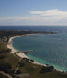
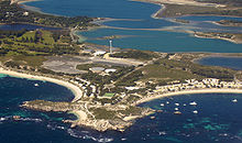
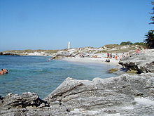 The Basin and Bathurst Lighthouse
The island became largely devoted to recreational use from the 1900s, aside from a brief period of exclusive military use during World War II. It is now visited annually by nearly 500,000 visitors, an average of 330,000 of those arriving by ferry or air taxi.[22] 70% of all visitors come for the day only. The majority of visitors arrive in summer, with nearly 20% of all visitors coming in January.
The main settlement is located at Thomson Bay, which is a protected north-easterly bay facing the mainland. Other settlements are located at Geordie Bay and Longreach Bay on the northern side of the island. All are sheltered bays and well suited for boating and swimming. Many other bays around the island have permanent boat moorings which can be leased from the Rottnest Island Authority.
The island has accommodation for up to 2,850 visitors, while day-only visitors can number up to 5,000 at any one time.[23] Rottnest Island Authority accommodation options include 308 villas, units and cottages which sleep 4, 6 or 8 people and which are self-catering. This style of accommodation is reasonably basic. Demand for accommodation is very high during the summer months, with ballots held annually for accommodation during the January and Easter school holiday periods.
Other accommodation options include the YHA and group accommodation at Kingstown Barracks, the Hotel Rottnest (formerly called the "Quokka Arms Hotel" and prior to that the Governor's residence), the Rottnest Lodge and a camping ground which includes campsites and as well as semi-permanent tents.[24]
Most visitors arrive on one of the ferries from Fremantle, Perth, and Hillarys. These are operated by Boat Torque/Rottnest Express, Hillarys Fast Ferries and Oceanic Cruises. Rottnest Island Airport for light aircraft (YRTI) is located near the main settlement.
The island is popular destination with Year-12 school leavers celebrating the end of their exams each November (known in Western Australia as 'Leavers week' or just 'Leavers') - the island is closed to the general public during this time. Identification and proof of being a current secondary school leaver is required to access the island during this period.
Catering facilities in the Thomson Bay foreshore area include a Dome coffee shop, a seafood restaurant and the Hotel Rottnest. The main settlement has a general store including a liquor outlet, a bakery, cafe/coffee shop, Red Rooster, Subway and clothing stores. The Lodge includes several restaurants and bars also. Longreach includes a general store and liquor outlet.
A luxury hotel was planned for the island, due to have opened by the 2008-09 summer. In March 2009 negotiations between the Rottnest Island Authority and the developer, Broadwater Hotels, collapsed. The Authority stated that "The development of a new hotel at Mt Herschel remains a priority for the Authority, and we will be going to the market with a request for proposals in the next few months." [25] The Rottnest Society has criticised the state government over lack of public consultation over the development: "The government has let us all down in not keeping a written commitment to allow the Western Australian public to comment via a properly constituted public comment process on the concept plans for the proposed new hotel at Mt Herschel". The Society "... is seriously concerned that the introduction of 'high-end' tourists may well bring pressure for more 'up-market' facilities and services on the island, more coach tours, and a much greater disparity between 'high-end' and 'low-end' accommodation."[26]
The island was the site of an important Australian High Court case. Nagle v Rottnest Island Authority (1993) 177 CLR 423 arose after a man, dove off a rock on Rottnest Island and became a quadriplegic.[27] It was held that, as the island authority had promoted the site as a venue for swimming and had not put up a warning notice, it was liable for causing the injury.
Activities
Diving is a popular activity at Rottnest. Its varied limestone reef terrain, and plentiful fish make it a interesting diving destination. In particular, diving for crayfish Western rock lobster, is popular in the summer months. The season opens on 15 November each year, and runs until 30 June. Crayfish may be caught in special traps or "pots", or when diving either by hand or by using a crayfish "loop". The loop is a spring-loaded steel cable attached to a long pole. It is illegal to use any means that might puncture the shell to catch the crayfish. The bag limit is 6 per license per day, with a maximum of 12 per boat per day.
A snorkel trail at Parker Point features underwater interpretative plaques that give information about the marine environments surrounding Rottnest. The island is the southernmost point along the Western Australian coastline at which coral grows.[citation needed] The Rottnest Island Wreck Trail was developed in conjunction with the Western Australian Museum in 1980 as the first underwater interpretative trail in the southern hemisphere. Visits to some of the Rottnest Island shipwrecks, in essence a museum-without-walls can be made by glass bottomed boat, or by scuba and snorkel. The SS Macedon site is one of the most visited wrecks in Australia.[citation needed]
The island features historic buildings and pleasant beaches (all reachable via the many cycling tracks; cycling being the island's main mode of transport - private or hire cars are not allowed on the island).
Annual events
- The Rottnest Channel Swim is a long distance swimming event from Cottesloe Beach to Rottnest Island, is held annually.
- The Rottnest Marathon & Fun Run is an annual running event operated late each October by the West Australian Marathon Club. Event distances are 5 km, 10 km and Marathon (42.2 km).
- The 'Rottnest Comedy & Short Film Festival' is an event showcasing Western Australian Short Comedy Films, Stand-Up Comedians and Musicians held annually from 2009.
- Leavers week (November)
- 'Swim Thru Rottnest' is an annual 1600-metre swim held on the first Saturday in December. The event was first held in 1977. Competitors start on the east side of the Army Jetty in Thomson Bay, swim to the natural jetty and then return to the Army jetty. The event is run by the Cottesloe Crabs Winter Swimming Club.
- 'The Doctor' is a 23 km surfski and paddle race from the Army jetty to Scarborough Beach.[28]
- 'Fremantle to Rottnest Big Splash' is a masters swimming race from Leighton Beach to Rottnest
Services
Rottnest Island has few permanent residents with most island workers commuting from the mainland.
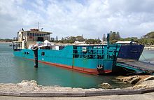
As Rottnest is isolated from the mainland, and has no fresh surface water, providing water, power and waste disposal has always been difficult and expensive. In 1996 Rottnest introduced the first public place recycling program in Western Australia. In 2000 the island won the 3R awards (reduce, reuse and recycle). A daily supply barge - Spinifex - makes a return trip from Fremantle, delivering supplies and removing rubbish.
For many years during the twentieth century, the water supply was rainwater harvested from several large bitumen sealed catchment areas behind Longreach Bay. In the 1970s fresh water was found underground and was used to supplement the rainfall supply. In 1995 the supply was further supplemented with desalinated groundwater, using a reverse osmosis plant producing up to 500 kL per day.
Experimental wind turbines were commissioned in 1978,[29] however high maintenance requirements and excessive power generation resulted in diesel remaining the main power source. In 2004 a new 600 kW wind-diesel system was erected; other works at the time included upgrades to the power station and the installation of low load diesel generators.[30] The wind turbine delivers approximately 37% of Rottnest's power requirements and saves over 400,000 litres of diesel per year and reduce greenhouse gas emissions by over 1,100 tonnes.[31]
Two lighthouses operate on the island to aid passing maritime traffic: Bathurst Lighthouse and Wadjemup Lighthouse.
Popular culture
- The US television show The Amazing Race 9 featured an episode with events on the island.
- The movie Under the Lighthouse Dancing was filmed on the island.
- An episode of the ABC TV program Surfing the Menu was filmed on the island.
- An eight-minute film, Amy Goes To Wadjemup Island, was shot on the island in 2006.
- An early film, Trip to Rottnest, made by the Australian Government to popularise Rottnest as a holiday destination, is thought to be one of the first of its kind.[32]
- Rottnest features prominently in Robert Drewe's memoir The Shark Net.
- The West Australian poet and author Hal Gibson Pateshall Colebatch (whose father, Sir Hal Colebatch was the first Chairman of the Rottnest Island Board), has written many poems about Rottnest, especially in his collection The Light River (Connor Court publishers, 2007). Colebatch's 2011 novel "Countertstrike" (Acashic) also has scenes set on Rottnest, which is called Lighthouse Island in the book.
- West Australian author and Supreme Court Judge Nicholas Hasluck has also written poems and fictionalised accounts of Rottnest.
See also
- List of features of Rottnest Island — alpha lists of cottage names, and named features usually found on Rottnest maps
- Rottnest Island shipwrecks — details on the twelve larger shipwrecks in close proximity to the island
- Colonial buildings of Rottnest Island
References
- ^ Rottnest Police station details
- ^ Welcome to Wadjemup, The Sunday Times, page: 5, published: 24 October 2010, accessed: 25 October 2010
- ^ "History and Culture". Rottnest Island Authority. http://www.rottnestisland.com/en/History+and+Culture/default.htm.
- ^ Hesp, Patrick A., Murray-Wallace, Colin V. and C. E. Dortch, (1999), "Aboriginal occupation on Rottnest Island, Western Australia, provisionally dated by Aspartic Acid Racemisation assay of land snails to greater than 50 ka" (Australian Archaeology, No 49 (1999)
- ^ a b Appleyard, R.T. and Manford, Toby (1979). The Beginning: European Discovery and Early Settlement of Swan River, Western Australia, University of Western Australia Press. ISBN 0-85564-146-0.
- ^ Heeres, J. E. (1899). The Part Borne by the Dutch in the Discovery of Australia. London: Luzac and Co.. p. 77. http://gutenberg.net.au/ebooks05/0501231h.html. Retrieved 2006-12-12.
- ^ VOC Historical Society - de Vlamingh
- ^ "The History of Australian Exploration, Chapter 17". http://gutenberg.net.au/ausexplore/ausexpl2-17.html.
- ^ "ANSWERS TO CORRESPONDENTS.". The West Australian (Perth, WA : 1879 - 1954) (Perth, WA: National Library of Australia): p. 14. 22 February 1934. http://nla.gov.au/nla.news-article32792909. Retrieved 7 November 2011.
- ^ "THE ROTTNEST REFORMATORY.". The West Australian (Perth, WA : 1879 - 1954) (Perth, WA: National Library of Australia): p. 2. 19 May 1898. http://nla.gov.au/nla.news-article3212062. Retrieved 7 November 2011.
- ^ "ROTTNEST ISLAND.". The West Australian (Perth, WA : 1879 - 1954) (Perth, WA: National Library of Australia): p. 18. 24 March 1934. http://nla.gov.au/nla.news-article33015554. Retrieved 7 November 2011.
- ^ "THE EARLY DAYS.". The West Australian (Perth, WA : 1879 - 1954) (Perth, WA: National Library of Australia): p. 20. 5 June 1931. http://nla.gov.au/nla.news-article32524538. Retrieved 7 November 2011.
- ^ "Heritage Icons - Rottnest Island". The Constitutional Centre of Western Australia. http://www.ccentre.wa.gov.au/175thAnniversary/HeritageIcons/Pages/May-RottnestIsland.aspx. Retrieved 6 November 2011.
- ^ "Rottnest Island, Western Australia (1914–15 and 1940)". National Archives of Australia. http://www.naa.gov.au/whats-on/online/feature-exhibits/internment-camps/wwii/rottnest-island.aspx. Retrieved 2010-06-19.
- ^ Kilpatrick, Alan G. (July 1932). The Emu. http://www.publish.csiro.au/?act=view_file&file_id=MU932030.pdf.
- ^ "IBA: Rottnest Island". Birdata. Birds Australia. http://www.birdata.com.au/iba.vm. Retrieved 2011-10-01.
- ^ "A close encounter of the furry kind". Australian Geographic. 2010. http://www.australiangeographic.com.au/journal/a-close-encounter-of-the-furry-kind.htm. Retrieved 2010-04-22.
- ^ "Reptiles and amphibians of Rottnest". Rottnest Island Authority. http://www.rottnestisland.com/en/About_Rottnest_Island/Flora_and_fauna/Pages/Reptiles_and_amphibians.aspx. Retrieved 2010-10-18.
- ^ "Seals making home on Rottnest may attract sharks to area". PerthNow. March 6, 2010. http://www.perthnow.com.au/news/western-australia/seals-making-home-on-rottnest/story-e6frg13u-1225837692792.
- ^ "Plants and wildflowers of Rottnest Island". Rottnest Island Authority. http://www.rottnestisland.com/en/About_Rottnest_Island/Flora_and_fauna/Pages/Plants_and_wildflowers.aspx. Retrieved 2010-06-19.
- ^ "Climate statistics for Rottnest Island". Weatherzone. http://www.weatherzone.com.au/climate/station.jsp?lt=site&lc=9193. Retrieved 30 Oct 2011.
- ^ "About Rottnest Island". Rottnest Island Authority. 2005. http://www.rottnestisland.com/en/About+Rottnest+Island/default.htm. Retrieved 2006-07-18.
- ^ "Rottnest Island Wastewater Treatment Plant". Human settlements / Corporate sustainability. Department of the Environment and Heritage (Australia). 1997 (2005). http://eriss.erin.gov.au/settlements/industry/corporate/eecp/publications/wastewater/rottnest.html. Retrieved 2006-07-18.
- ^ "Accommodation - Rottnest Island". Rottnest Island Authority. 2005. http://www.rottnestisland.com/en/Accommodation/default.htm. Retrieved 2006-07-18.
- ^ http://www.wabusinessnews.com.au/en-story/1/70962/Talks-break-down-over-Rottnest-hotel-
- ^ "Rottnest Society statement on Mount Herschel development". http://www.rottnestsociety.org.au/MtHerschell_site.htm.
- ^ "Nagle v Rottnest Island Authority [1993 HCA 76; 177 CLR 423; (1993) Aust Torts Reporter 81-211; (1993) 112 ALR 393; (1993) 67 ALJR 426 (21 April 1993)"]. Australasian Legal Information Institute. http://www.austlii.edu.au/cgi-bin/sinodisp/au/cases/cth/HCA/1993/76.html?&nocontext=1. Retrieved 4 January 2011.
- ^ "The Doctor". http://www.oceanpaddler.com/Static/Events/TheDoctor/Default.aspx.
- ^ "Harnessing wind power". Verve Energy. http://www.verveenergy.com.au/mainContent/sustainableEnergy/Sustainable%20technologies/Wind_power.html. Retrieved 14 August 2011.
- ^ "Rottnest Island". Verve Energy. http://www.daws.com.au/projects/Rottnest_Island.html. Retrieved 14 August 2011.
- ^ Rottnest Island Environmental Initiatives The Rottnest Island Authority. Retrieved 17 October 2006.
- ^ "A Trip to Rottnest [videorecording"]. State Library of Western Australia. http://henrietta.slwa.wa.gov.au/record=b1384733~S2. Retrieved 2010-07-24.
External links
Australian places named by Dutch explorers in the 17th Century1 Queensland Staaten River (Staten Riuier) · Carpentaria

Northern Territory Vanderlin Island (Cap Vanderlin) · Groote Eylandt · Arnhem Land (Arnhems Landt) · Crocodile Islands (Cocodrils Eÿlandt) · Van Diemen Gulf (Baÿa van-Diemen)
Western Australia Houtman Abrolhos2 · Rottnest Island (Eyland Rottenest) · Swan River (Swarte Swaene-Revier)
South Australia St Francis Island (Eyland St. Francois) · St Peter Island (Eyland St. Pierre)
Tasmania Maatsuyker Island (Maetsuickers eylan) · Pedra Branca2 · Storm Bay · Maria Island (Marias Eylandt) · Schouten Island (Schoute Eylandt)
Notes: 1with the name still in use in either original or Anglicised version · 2Named by the Dutch, but a Portuguese name · Many names have been Anglicised; (for these the original Dutch name appears in brackets)
Categories:- Car-free areas
- Islands of Western Australia
- Islands of the Indian Ocean
- Landmarks in Perth, Western Australia
- Visitor attractions in Perth, Western Australia
- Rottnest Island
- Important Bird Areas of Australia
Wikimedia Foundation. 2010.

