- Tebay
-
Coordinates: 54°26′02″N 2°35′24″W / 54.434°N 2.590°W
Tebay 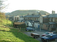
Railway Cottages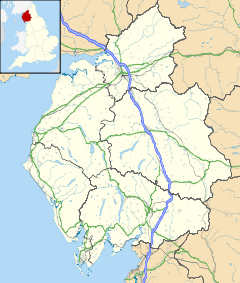
 Tebay
Tebay
Tebay shown within CumbriaPopulation 728 (2001) OS grid reference NY618045 Parish Tebay District Eden Shire county Cumbria Region North West Country England Sovereign state United Kingdom Post town PENRITH Postcode district CA10 Dialling code 01539 Police Cumbria Fire Cumbria Ambulance North West EU Parliament North West England UK Parliament Penrith and The Border List of places: UK • England • Cumbria Tebay is a village and civil parish in Cumbria, England, within the traditional borders of Westmorland. It lies in the upper Lune Valley, at the head of the Lune Gorge. The parish of Tebay had a population of 728 recorded in the 2001 census,[1]
Old Tebay lies to the north of Tebay at grid reference NY618052. Historically a sheep farming area, the arrival of the railway led to increased prosperity.
Contents
History
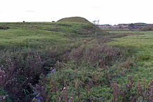 Castle Howe
To the north, occupying a strategic position by the river Lune, now close to the M6 motorway, are the earthwork remains of a motte and bailey castle known as Castle Howe.
Transport
Railways
The Lancaster and Carlisle Railway, built between 1844 and 1846, linked those two cities; it was absorbed by the London and North Western Railway in 1879. Tebay became an important junction for, in 1861, the Stainmore Railway, from Tebay-Kirkby Stephen-Barnard Castle and later becoming part of the North Eastern Railway, brought traffic from the east; it was closed in 1962. The A685 runs over much of its trackbed east from Tebay towards Kirkby Stephen. The Ingleton Branch of the Lancaster and Carlisle Railway connecting via the Midland Railway to Settle and Leeds, enters the main line at the south end of the Lune Gorge; it was built in the 1850s, and was last used for passengers in the winter 1962/63 as a relief to the main line.
The village has had two railway accidents happen nearby. On 15 February 2004, four people were run over by a maintenance vehicle in the Tebay rail accident. Three years later, the Grayrigg rail crash happened on 23 February 2007 between Oxenholme and Tebay on the West Coast Main Line.
Roads
Junction 38 of the M6 lies just west of the village, south of the notoriously exposed Shap Summit. Like its predecessor, the main railway line, it uses the upper reaches of the River Lune to pass through the fells. Tebay services is one of the very few motorway service stations to be run independently, and has often won praise for its food.
The village
Central to the village is the Railway Club. This provides a concrete link to the past raison d'etre of the village. The two pubs in the village also provide a place where the inhabitants can come together. In times past a great proportion of populace was involved with the railway and the local Junction Hotel is now apartments where once were dance halls.
See also

Penrith Greenholme 
Kirkby Stephen  Tebay
Tebay 

Sedbergh References
External links
Ceremonial county of Cumbria Boroughs or districts Major settlements - Alston
- Ambleside
- Appleby-in-Westmorland
- Aspatria
- Barrow-in-Furness
- Bowness-on-Windermere
- Brampton
- Broughton-in-Furness
- Carlisle
- Cleator Moor
- Cockermouth
- Dalton-in-Furness
- Egremont
- Grange-over-Sands
- Harrington
- Kendal
- Keswick
- Kirkby Lonsdale
- Kirkby Stephen
- Longtown
- Maryport
- Millom
- Penrith
- Sedbergh
- Silloth
- Ulverston
- Whitehaven
- Wigton
- Windermere
- Workington
See also: List of civil parishes in Cumbria
Topics Categories:- Cumbria geography stubs
- Villages in Cumbria
- Railway towns in England
- Westmorland
- Civil parishes in Cumbria


Wikimedia Foundation. 2010.