- Mountain View Corridor
-
Mountain View Corridor
Route information Maintained by UDOT Length: 35 mi (56 km) Major junctions South end:  SR-73 in Lehi
 I-15 in Lehi
 SR-48 in West Jordan
 SR-201 in West Valley City
North end:  I-80 in Salt Lake City
Highway system State highways in Utah
Interstate • US • State (Parks) • Scenic←  I-84
I-84SR-86  →
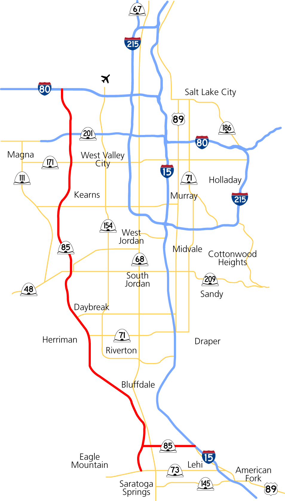
→ The Mountain View Corridor—delineated in red—portrayed at full build-out
The Mountain View Corridor, numerically designated as State Route 85 (SR-85), is an expressway currently under construction that will run along the western periphery of Salt Lake County and northwest Utah County in northern Utah. A spur of the eventual freeway to Interstate 15 opened in northwestern Utah County September 2011. Mountain View will start in Salt Lake City west of the Salt Lake City International Airport, diverging from Interstate 80, and end at SR-73 near Lehi. It will run north–south at 5800 West for most of its 35-mile (56 km) extent in Salt Lake County before curving southeastward toward SR-73 in Lehi. The spur between SR-85 (initially SR-68) and I-15 runs along 2100 North in Lehi's street grid.
Plans call for three phases of construction. During the first phase, crews will build two lanes in each direction. The roadway will curve out to the edges of the right of way where future off-ramps will be, creating two one-way intersections. This preserves space in the middle to build overpasses, as funding and need permits, during phase two. On the 2100 North spur in Utah County, as well as the southern portion of the Salt Lake County roadway, crews will build two one-way frontage roads, leaving space for phase-two freeway construction in the middle. Full freeway-to-freeway ramps will also be part of phase two. Phase three will widen the freeway from two lanes to five in each direction, with one of those lanes provisioned as an HOV lane.
The environmental impact statement for the freeway was completed in November 2008,[1] leaving funding for the highway as the biggest remaining obstacle. Previous proposals included raising the state fuel tax or tolling the new road as a public/private partnership, an issue that became highly contentious.[2] Ultimately, the state legislature decided to bond the freeway, using future tax receipts to pay for it.[3]
The road, when constructed, will be designated State Route 85[4] in the Utah state highway system; it will also be maintained by the Utah Department of Transportation. Both the main freeway and the spur will carry the SR-85 designation.
In mid-2010, Utah County planners discussed future plans for a freeway in Utah County from Lehi to Santaquin along the west side of SR-68 west of Utah Lake. It has been speculated that this could become part of the Mountain View Corridor project.[5]
Contents
Construction
The first stage of the Utah County portion, the 2100 North spur, began construction in late 2010 and opened 24 September 2011.[6][7] This stage connects Interstate 15 to Redwood Road (SR-68) along 2100 North in Lehi. The roadway initially contains four lanes and includes stoplights. The second phase will convert the intersections to interchanges; the spur will also extend to the mainline roadway west of Redwood Road. As in the southern Salt Lake County portion, the third phase will widen the roadway.[8]
For the first stage of the Salt Lake County portion, a fifteen-mile stretch of four-lane expressway akin to Bangerter Highway (SR-154) will be constructed from Redwood Road near Bluffdale to 5400 South (SR-173) on the west side of Salt Lake County.[9] The first phase of construction began in mid-2010 and is scheduled to finish by the end of 2012.[10] Future phases will extend the road north to I-80 west of the Salt Lake City International Airport and south to SR-73 in Lehi. The roadway will be converted to a freeway in these future phases, as with the 2100 North spur.
Exit list
This exit list depicts the Mountain View Corridor at full build-out.
County Junction[11] Notes Salt Lake I-80 Northern terminus
System (freeway-to-freeway) interchangeCalifornia Avenue Diamond interchange SR-201 System interchange 2700 South Diamond interchange
Southbound entrance, northbound exit3500 South (SR-171) Single-point urban interchange 4100 South Single-point urban interchange 5400 South (SR-173) Diamond interchanges 6200 South 7800 South 9000 South (SR-48) Old Bingham Highway Diamond interchanges (with one-way Texas-style frontage roads) South Jordan Parkway Daybreak Parkway 11800 South 12600 South 13400 South 14400 South South Hills Boulevard Utah 2100 North System interchange
Spur to I-15SR-73 Southern terminus References
- ^ "Feds approve Mountain View Corridor". Daily Herald (Provo). http://www.heraldextra.com/news/local/article_cab424c1-8c68-5f39-961e-d0e8f822c424.html. Retrieved March 11, 2010.
- ^ "Foes of Mountain View toll road form group". Deseret Morning News (Salt Lake City). http://www.deseretnews.com/article/650205030/Foes-of-Mountain-View-toll-road-form-group.html. Retrieved March 11, 2010.
- ^ "Huntsman signs state transportation project bills". Daily Herald (Provo). http://www.heraldextra.com/news/state-and-regional/article_163f1fbe-7592-5806-8822-26e46a26ab38.html. Retrieved March 11, 2010.
- ^ "State Routes in Region 2". Utah Department of Transportation. http://www.udot.utah.gov/main/f?p=100:1:0. Retrieved March 11, 2010.
- ^ Utah County planners seek to avoid Lehi-like traffic woes. Deseret Morning News. May 11, 2010.
- ^ "Construction on Mountain View Corridor finally underway". KSL. http://www.ksl.com/?nid=148&sid=9952934. Retrieved March 11, 2010.
- ^ "2100 North: One-way gets you there better". Utah Department of Transportation. http://udot.utah.gov/mountainviewutcounty/content/2100-north-one-way-getting-there-getting-better. Retrieved 12 September 2011.
- ^ "Lehi, UDOT compromise on corridor". Deseret Morning News (Salt Lake City). http://www.deseretnews.com/article/1,5143,695273191,00.html. Retrieved March 11, 2010.
- ^ "Mountain View Corridor to extend into Kearns". Deseret Morning News (Salt Lake City). http://www.deseretnews.com/article/705336683/Mountain-View-Corridor-to-extend-into-Kearns.html. Retrieved March 11, 2010.
- ^ "Salt Lake County construction project". Utah Department of Transportation. http://www.udot.utah.gov/mountainviewslcounty/. Retrieved 12 September 2011.
- ^ "Mountain View Corridor". Utah Department of Transportation. http://www.udot.utah.gov/mountainview/. Retrieved 9 August 2010.
External links
Major highways in the Salt Lake City area Radial Circumferential Proposed Legacy Highway • Mountain View CorridorCategories:- State highways in Utah
- Proposed state highways in the United States

Wikimedia Foundation. 2010.