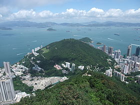
- Mount Davis, Hong Kong
-
Mount Davis 
A view of Mount Davis from High WestElevation 269 m (883 ft) Location Location Hong Kong Coordinates 22.277028°N 114.124789°E Mount Davis Traditional Chinese 摩星嶺 Transcriptions Mandarin - Hanyu Pinyin Móxīng Lǐng Cantonese (Yue) - Jyutping mo1 sing1 leng5 Mount Davis is a hill in Kennedy Town, Hong Kong Island, Hong Kong. It is the westernmost hill on Hong Kong Island.
It is named after John Francis Davis, who was the 2nd Governor of Hong Kong, from 1844 to 1848.
The summit is reached via Mt Davis Path, which comes off Mt Davis Road and Victoria Road.
Contents
History
It was an important artillery depot of the British forces since 1911 (proposed in 1900). 5 (later 3) 9.2" guns were installed. It was heavily bombed by Japanese planes during the Battle of Hong Kong. The depot was later demolished by British defenses towards the end of the battle.
Geology
The geology of Mount Davis comprises dominantly pyroclastic rocks of the Cretaceous Repulse Bay Volcanic Group (Sewell et al., 2000). This same kind of rock is common in the south of Hong Kong Island and the east and north New Territories. The rock type in Mount Davis is mainly coarse ash crystal tuff.
Features
On top of the hill are remains of old gun batteries and a barracks from the Second World War, making it a famous wargame site for Hong Kong airsofters, though due to complaints, the Police will respond to any airsofters discharging pellet guns in the area and disperse them. There is a youth hostel (Hong Kong - Jockey Club Mt. Davis) on top of the hill.
There is an ionopsheric station housing an ionosonde. The ionosonde was set up in a refurbished bunkhouse by Oulton Walker and Tim Closs of the Hong Kong University Physics department in 1969. There are also microwave towers.
The eastern side of the hill holds the Chiu Yuen Cemetery, private cemetery of the Hotung clan. The North East face has Kwun Lung Lau one of the earliest public housing developments in Hong Kong. Kennedy Town is on the north side.
See also
References
- P.K.MacKeown Physics at The University of Hong Kong – an anecdotal history
- 2003 Hong Kong City Guide ISBN 962-14-2537-9
- Hong Kong Geological Survey I:20,000-scale Geological Map Sheet No. 11
- Sewell,R.J., Campbell, S.D.G., Fletcher, C.J.N., Lai, K.W. & Kirk, P.A. (2000). The Pre-Quaternary Geology of Hong Kong. Geotechnical Engineering Office, Hong Kong. 181 p. ISBN 962-02-0299-6
Coordinates: 22°16′37″N 114°07′29″E / 22.277028°N 114.124789°E
Categories:
Wikimedia Foundation. 2010.
