- Oberbergischer Kreis
-
Coat of arms Map 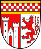
Oberbergischer Kreis — District — 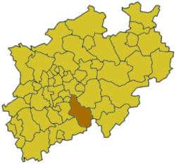
Country  Germany
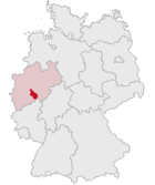
State North Rhine-Westphalia Adm. region Cologne Capital Gummersbach Area – Total 918.53 km2 (354.6 sq mi) Population (31 December 2010)[1] – Total 280,840 – Density 305.7/km2 (791.9/sq mi) Time zone CET (UTC+1) – Summer (DST) CEST (UTC+2) Vehicle registration GM Website http://www.oberbergischer-kreis.de The Oberbergischer Kreis is a Kreis (district) in the state of North Rhine-Westphalia, Germany. Neighboring districts are Ennepe-Ruhr, Märkischer Kreis, Olpe, Altenkirchen, Rhein-Sieg, Rheinisch-Bergischer Kreis, and the urban districts Remscheid and Wuppertal.
Contents
Name
The area of the Bergisches Land belonged to the County of Berg for most of the medieval times, which still gives the district its name. What is called "Oberbergisch" ('upper Bergian') lies in the southeast of that earldom: Already in 1740, a description of what had meanwhile become a duchy made a distinction between the "Niederbergisch" part north of the river Wupper and the "Oberbergisch" to its south.
In 1816, after the whole Rhineland was annexed to Prussia, the districts of Waldbröl, Homburg, Gimborn, Wipperfürth, and Lennep were created on the area now covered by the district. In 1825 the districts Gimborn and Homburg were merged to the district Gummersbach. In 1932 it was merged with the district of Waldbröl, and then for the first time called Oberbergischer Kreis. The restructuring of the districts in 1969/75 did then create the district to its current extent.
Geography
The Oberbergischer Kreis covers the hills west of the Sauerland and north of the Westerwald. It constitutes the eastern part of the Bergisches Land nature reserve. Situated at an altitude of 100–520 meters above sea level, it is rich in wood and water (numbering ten artificial lakes) and thus a recreational area for citizens from Cologne, the Ruhr area and the Netherlands.
The prevailing rock is greywacke, which was and in places still is mined in large stone quarries.
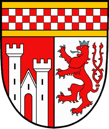
Coat of arms
The coat of arms is a combination of the heraldic signs of the territories the district belonged to. The red-white bar in the top symbolizes the County of Mark and the lion that of Berg. Homburg Castle (near Nümbrecht) was the seat of the Princes of Sayn-Wittgenstein-Berleburg. Politics
District Administrator
- 1945-1951: Dr. August Dresbach, CDU
- 1951-1952: Fritz Eschmann, SPD
- 1952-1956: Wilhelm Henn, CDU
- 1956-1961: Fritz Eschmann, SPD
- 1961-1964: Reinhard Kaufmann, CDU
- 1964-1969: Dr. Heinrich Schild, CDU
- 1969-1989: Hans Wichelhaus, CDU
- 1989-1994: Hans-Leo Kausemann, CDU
- 1994-1999: Herbert Heidtman, SPD
Since the October 1st, 1999 there is only one (directly elected) District Administrator who at the same time is head of management:
- 1999-2004: Hans-Leo Kausemann, CDU
- 2004-today: Hagen Jobi, CDU
District Administrator for the management
- 1946-1979: Dr. Friedrich-Wilhelm Goldenbogen, CDU
- 1979-1987: Dr. Dieter Fuchs, CDU
- 1987-1994: Dr. Gert Ammermann, CDU
- 1995-1999: Heribert Rohr, SPD
Economy
The district's economy is marked by small and middle-sized industry, particularly in the areas of plastic and metal processing.
Places of interest
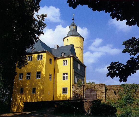
 Homburg Castle
- The so-called 'colored churches' (with medieval wall and cover paintings) are known nationally
- Stalactite cave in Wiehl
- Rhenish industry museum in Engelskirchen
- House Dahl
- Open-air museum in Lindlar
- Gimborn Castle
- Homburg Castle
- Hückeswagen Castle and the historical part of Hückeswagen
- Ehreshoven Castle
- Denklingen Castle
Towns and municipalities
Towns Municipalities References
- ^ "Amtliche Bevölkerungszahlen" (in German). Landesbetrieb Information und Technik NRW. 31 December 2010. http://www.it.nrw.de/statistik/a/daten/amtlichebevoelkerungszahlen/index.html.
External links
 Media related to Oberbergischer Kreis at Wikimedia Commons
- Official website (German)
- Touristical website (German)
- Kreisinformationssystem Oberberg (German)
 Urban and rural districts in the state of North Rhine-Westphalia in Germany
Urban districts Bielefeld · Bochum · Bonn · Bottrop · Dortmund · Duisburg · Düsseldorf · Essen · Gelsenkirchen · Hagen · Hamm · Herne · Köln (Cologne) · Krefeld · Leverkusen · Mönchengladbach · Mülheim · Münster · Oberhausen · Remscheid · Solingen · Wuppertal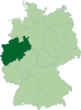
Rural districts Aachen · Borken · Coesfeld · Düren · Ennepe-Ruhr-Kreis · Euskirchen · Gütersloh · Heinsberg · Herford · Hochsauerlandkreis · Höxter · Kleve (Cleves) · Lippe · Märkischer Kreis · Mettmann · Minden-Lübbecke · Oberbergischer Kreis · Olpe · Paderborn · Recklinghausen · Rheinisch-Bergischer Kreis · Rhein-Erft-Kreis · Rhein-Kreis Neuss · Rhein-Sieg-Kreis · Siegen-Wittgenstein · Soest · Steinfurt · Unna · Viersen · Warendorf · WeselCategories:- Districts of North Rhine-Westphalia
- Bergisches Land


Wikimedia Foundation. 2010.