- Coesfeld (district)
-
Coesfeld — District — 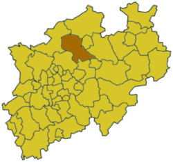
Country  Germany
State North Rhine-Westphalia Adm. region Münster Capital Coesfeld Area - Total 1.10979 km2 (0.4 sq mi) Population (31 December 2010)[1] - Total 219,784 - Density 198,041.1/km2 (512,924/sq mi) Time zone CET (UTC+1) - Summer (DST) CEST (UTC+2) Vehicle registration COE Website http://www.kreis-coesfeld.de Coesfeld (German pronunciation: [ˈkoːsfɛlt]) is a Kreis (district) in the northwestern part of North Rhine-Westphalia, Germany, west of the city of Münster. Neighboring districts are Steinfurt, district-free Münster, Warendorf, district-free Hamm, Unna, Recklinghausen, Borken.
Contents
History
In medieval times the region was subordinate to the bishopric of Münster. When the area became part of the Prussian province Westphalia in 1816 the new administration created two districts, Coesfeld and Lüdinghausen. Except minor changes they stayed until the major reorganization in 1975 when both were merged to form the current district. A few municipalities from the district Münster were also added, while others formerly belonging to the district were moved to neighboring districts.
Geography
The district is located in the Münsterland, a mostly rural area. The Lippe River forms part of the border of the district in the south.
Coat of arms
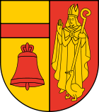
The coat of arms depicts a bishop, a goose and a bell. The bishop is Saint Liudger, the first bishop of Münster. The goose was according to a popular legend thrown into a dry well by Liudger, in order to find water during a drought. The bells of Lüdinghausen allegedly chimed by themselves, whenever Liudger entered the town. The left side derives from the former coat of arms of the district Lüdinghausen, while the right side comes from the old district Coesfeld. The coat of arms were granted in 1979. Towns and municipalities
Towns References
- ^ "Amtliche Bevölkerungszahlen" (in German). Landesbetrieb Information und Technik NRW. 31 December 2010. http://www.it.nrw.de/statistik/a/daten/amtlichebevoelkerungszahlen/index.html.
External links
 Media related to Kreis Coesfeld at Wikimedia Commons
- Official website (German) (English)
 Urban and rural districts in the state of North Rhine-Westphalia in Germany
Urban districts Bielefeld · Bochum · Bonn · Bottrop · Dortmund · Duisburg · Düsseldorf · Essen · Gelsenkirchen · Hagen · Hamm · Herne · Köln (Cologne) · Krefeld · Leverkusen · Mönchengladbach · Mülheim · Münster · Oberhausen · Remscheid · Solingen · Wuppertal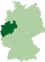
Rural districts Aachen · Borken · Coesfeld · Düren · Ennepe-Ruhr-Kreis · Euskirchen · Gütersloh · Heinsberg · Herford · Hochsauerlandkreis · Höxter · Kleve (Cleves) · Lippe · Märkischer Kreis · Mettmann · Minden-Lübbecke · Oberbergischer Kreis · Olpe · Paderborn · Recklinghausen · Rheinisch-Bergischer Kreis · Rhein-Erft-Kreis · Rhein-Kreis Neuss · Rhein-Sieg-Kreis · Siegen-Wittgenstein · Soest · Steinfurt · Unna · Viersen · Warendorf · WeselCategories:- Districts of North Rhine-Westphalia


Wikimedia Foundation. 2010.