- Deception Island
-
This article is about the island in Antarctica. For the island in Washington State, see Deception Pass.
 Deception IslandLocation of Deception Island
Deception Island 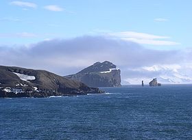
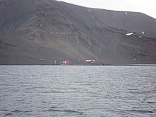
Entrance to Deception Island, with Livingston Island in the background.Elevation 576 m (1,890 ft) [1] Prominence 576 m (1,890 ft) Location Location Antarctica Coordinates 62°58′37″S 60°39′00″W / 62.97694°S 60.65°W Geology Type Caldera Last eruption 1970 Deception Island 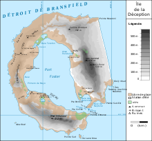
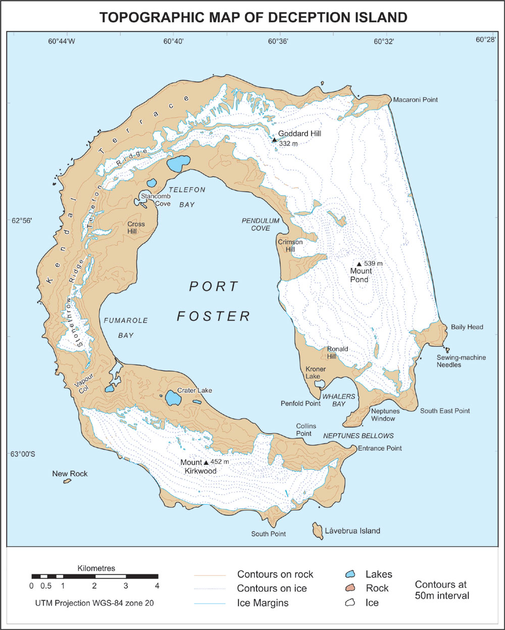
Map of Deception Island.
Location of Deception Island. Geography Location Antarctica Coordinates 62°58′37″S 60°39′00″W / 62.97694°S 60.65°W Length 12 km (7.5 mi) Width 12 km (7.5 mi) Country Demographics Population 0 Additional information Administered under the Antarctic Treaty System Deception Island is an island in South Shetland off the Antarctic Peninsula, which has one of the safest harbours in Antarctica. The island is the caldera of an active volcano, which caused serious damage to the local scientific stations in 1967 and 1969. The island previously held a whaling station; it is now a tourist destination and scientific outpost, with research bases being run by Argentina and Spain. Various countries have previously asserted sovereignty, but it is now administered under the Antarctic Treaty System.
Contents
Geography
The island, located at 62°58′37″S 60°39′00″W / 62.97694°S 60.65°W, is approximately circular with a diameter of about 12 km (7.5 mi). A peak on the east side of the island, Mt. Pond, has an elevation of 542 m (1,778 ft), and over half the island is covered by glaciers. The centre of the island is a caldera formed in a huge (VEI-6) eruption which has been flooded by the sea to form a large bay, now called Port Foster, about 9 km (5.6 mi) long and 6 km (3.7 mi) wide. The bay has a narrow entrance, just 230 m (755 ft) wide, called Neptunes Bellows. Adding to the hazard is Ravn Rock, which lies 2.5 m (8.2 ft) below the water in the middle of the channel. Just inside Neptunes Bellows lies the cove Whalers Bay, which is bordered by a large black-sand beach.
Several maars line the inside rim of the caldera, with some containing crater lakes (including one named Crater Lake). Others form bays within the harbour, such as the 1 km (0.6 mi) wide Whalers Bay. Other features of the island include Mount Achala, Primero de Mayo Bay, Sewing-Machine Needles, Telefon Bay and Telefon Ridge.
History
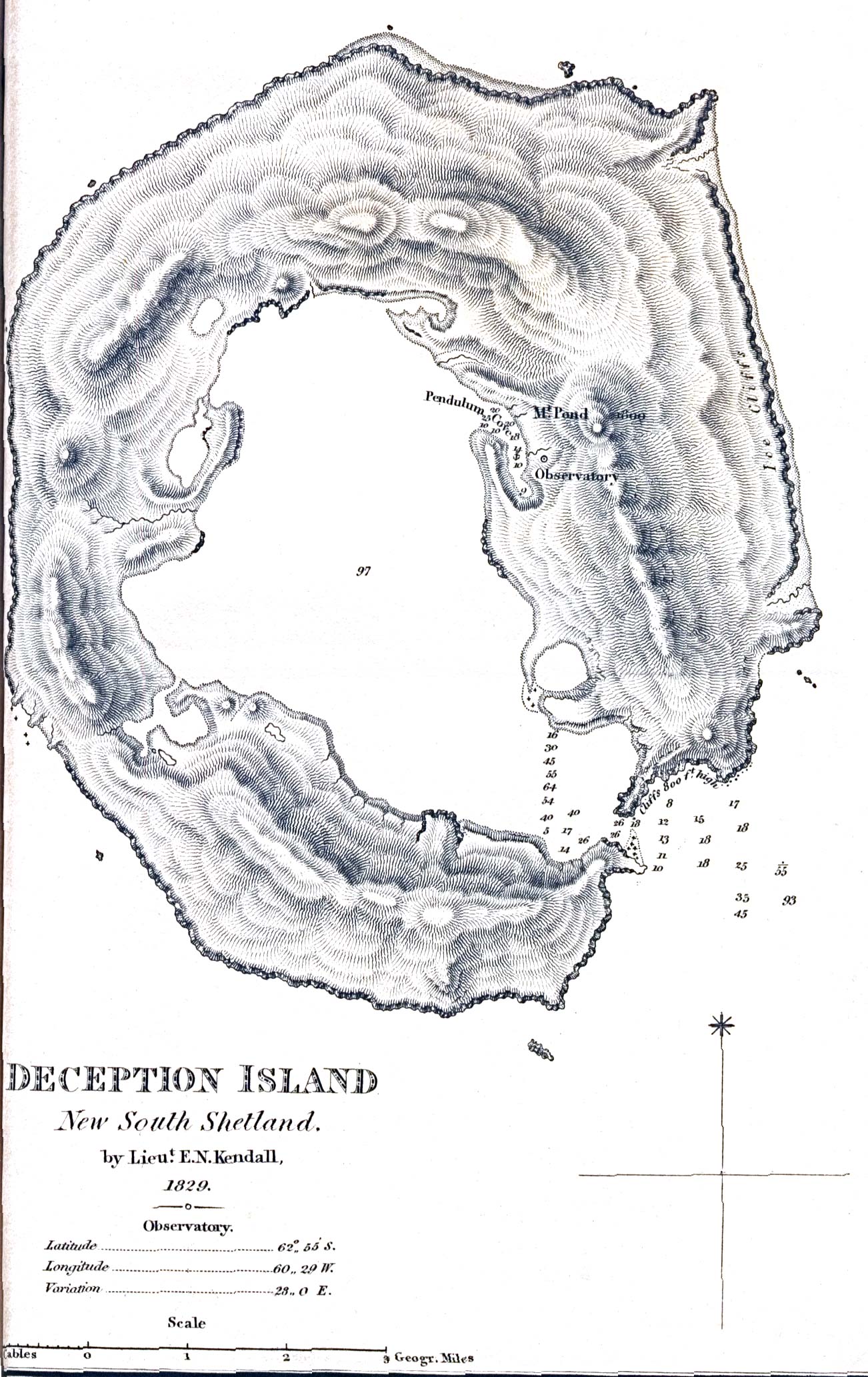
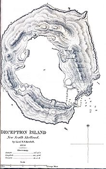 1829 map
Since the early 19th century, Deception Island was a favourite refuge area from the storms and icebergs of Antarctica. It was first used by sealers. In 1829, the British Naval Expedition to the South Atlantic under the command of Captain Henry Foster stopped at Deception Island, conducted a topographic survey and some scientific experiments there, particularly pendulum and magnetic observations.[2] In 1906, a Norwegian-Chilean whaling company started using Whalers Bay as a base for a factory ship, the Gobernador Bories. Other whaling operations followed suit, and by 1914 there were 13 factory ships based there.
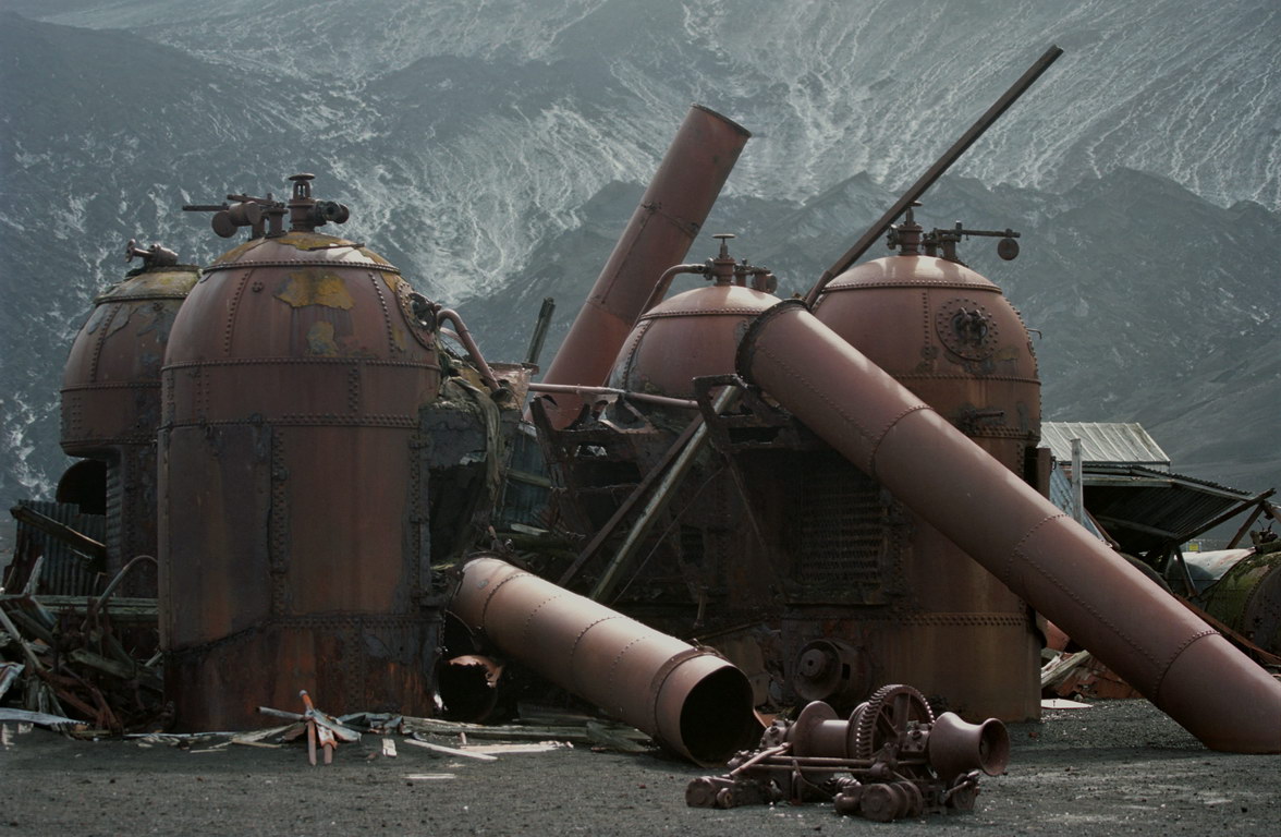
The station did not actually process whale blubber, which was done on the ships, but instead took the carcasses and boiled them down to extract additional whale oil, using large iron boilers, and storing the results in iron tanks.
Whale oil prices dropped during the Great Depression, making the station economically unprofitable, thus it was abandoned in 1931. Advances in factory ships made shore stations for carcass processing unnecessary, and so it was never reoccupied. Forty-five men were buried in the station's cemetery, but the cemetery was again buried in a 1969 volcano eruption, and the only remaining signs are the rusting boilers and tanks.
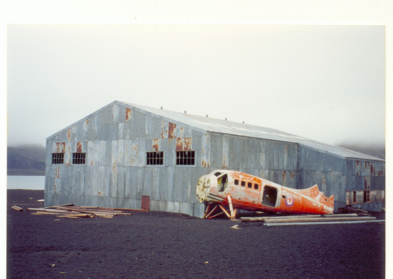
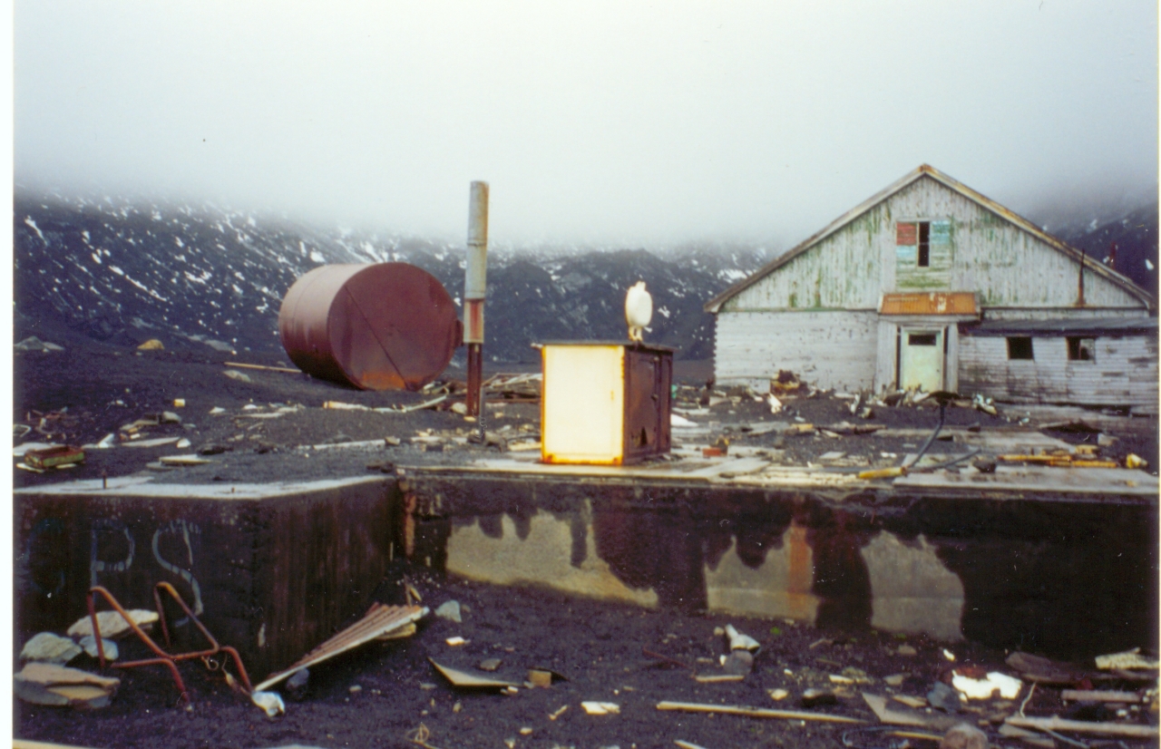
Other remains at Whalers Bay include an aircraft hangar with a bright orange derelict airplane fuselage outside (removed in 2004),[3] and the British scientific station house (Biscoe House), with the middle torn out by the mudflows in 1969.
In the 1940s and 1950s, Argentina contested control of Deception Island with the UK with some removals of the sovereign flag and temporary occupation of the island.[citation needed]
On 3 February 1944, the British established a permanent base on Deception Island as part of Operation Tabarin, and occupied it until 5 December 1967, when another volcanic eruption forced a temporary withdrawal. It was used again between 4 December 1968 and 23 February 1969, when further volcanic activity caused it to be abandoned.[4]
In 1955, Chile inaugurated its station Pedro Aguirre Cerda at Pendulum Cove, to increase the Chilean presence in the sector claimed by that nation.
In 1961, Argentina's president Arturo Frondizi visited to show his country's interest.
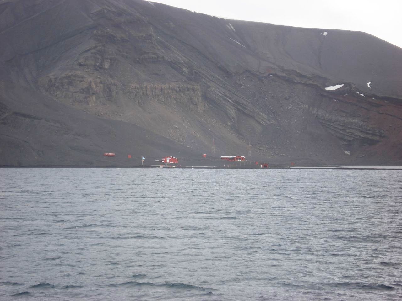
 Argentine Base Deception
In 1963, the American Coast Guard icebreaker USCGC Eastwind (WAGB-279) visited Deception Island. There were two scientific stations active, a British and a Chilean. The Chileans had an air strip and flew a DeHavilland Beaver back and forth to Punta Arenas for resupply. There were active fumaroles spewing noxious gases and some fumaroles had churning volcanic ash in the depressions. The Eastwind ran aground inside the volcano which is likely the only time an American military ship ever ran aground inside an active volcano. The ship refloated with the rising tide.[citation needed]
In 1969, a violent volcanic eruption demolished the Chilean stations Pedro Aguirre Cerda and Gutierrez Vargas. The volcano has mostly destroyed other attempts to maintain permanent facilities, and as of 2000, there were only two scientific stations still in use, both summer-only; Spain has the Gabriel de Castilla,[5] and Argentina has its Decepción Station.[3]
Ecology and micro climates
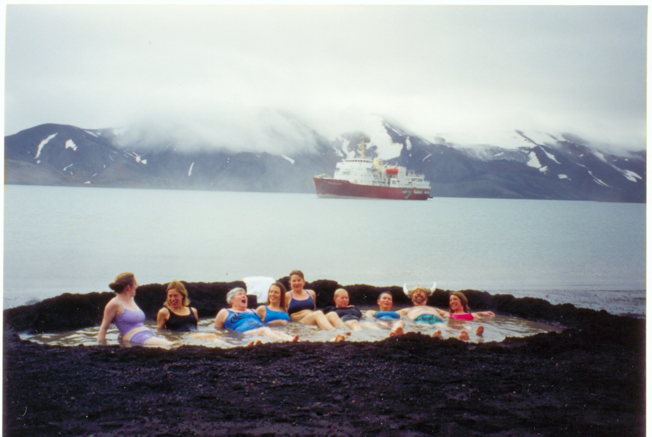
Deception Island has become a popular tourist stop in Antarctica because of its several colonies of chinstrap penguins, as well as the novel possibility of making a warm bath by digging into the sands of the beach. Baily Head on the west side of the island holds one of the world's largest chinstrap rookeries. Mount Flora is the first site in Antarctica where fossilized plants were discovered.[6]
After the Norwegian Coastal Cruise Liner MS Nordkapp ran aground off the coast of Deception Island on 30 January 2007, fuel from the ship washed into a bay. Ecological damage has not yet been determined. On 4 February 2007 the Spanish Gabriel de Castilla research station on Deception Island reported that water and sand tests were clean and that they had not found signs of the oil, estimated as 500 to 750 litres (130 to 200 US gallons; 110 to 160 imperial gallons) of light diesel.
Deception Island exhibits some wildly varying microclimates. Some water temperatures reach 70 °C (158 °F). Near volcanic areas, the air can be as hot as 40 °C (104 °F).[citation needed]
Gallery
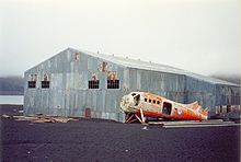
The derelict hangar 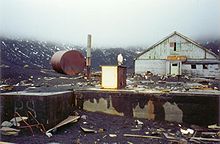
The destroyed British base 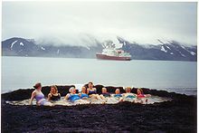
Warm volcanic bath at Port Foster 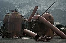
Remains of the whaling station's boilers See also
- Composite Antarctic Gazetteer
- List of Antarctic and sub-Antarctic islands
- List of Antarctic islands south of 60° S
- List of volcanoes in Antarctica
- South Shetland Islands
- SCAR
- Territorial claims in Antarctica
References
- ^ "Deception Island". Global Volcanism Program, Smithsonian Institution. http://www.volcano.si.edu/world/volcano.cfm?vnum=1900-03=. Retrieved 25 December 2008.
- ^ Gordon Elliott Fogg, A history of Antarctic science, Cambridge, Cambridge University Press, 1992, pp. 72-74
- ^ a b "4 April - Otter Recovery". British Antarctic Survey. http://www.antarctica.ac.uk/living_and_working/diaries/rrs_ernest_shackleton/antarctic2003_2004/27/index.php. Retrieved 24 May 2009.
- ^ Fuchs, Vivian (1982). Of Ice and Men. Oswestry: Anthony Nelson. pp. 291–2. ISBN 0904614069.
- ^ "Gabriel De Castilla". New Zealand: Shades Stamp Shop. http://www.newzeal.com/theme/bases/Spain/gabrieldecastilla.htm. Retrieved 24 May 2009.
- ^ Jurassic Liverworts from Mount Flora, Hope Bay, Antarctica
- Official Deception Island website. Accessed 3 May 2007.
- Volcanic Activity. Accessed 4 June 2007.
- Deception Island, Eco-Photo Explorers. Accessed 3 May 2007.
- LeMasurier, W. E.; Thomson, J. W.; et al. (1990). Volcanoes of the Antarctic Plate and Southern Oceans. American Geophysical Union. ISBN 0-87590-172-7.
External links
- Images from Deception Island
- Topographic map of Deception Island
- Página Web de la base Gabriel de Castilla
- "Steamed Ice and Frosted Lava" Account of a tourist visit to Deception Island
- British Deception Island station
- 21 photos of Deception island
- A visit to Deception Island, and other places on the Antarctic Peninsula, in 2002/3
- Antarctic suspense novel Deception Island
South Shetland Islands Major Minor - Aitcho
- (Barrientos
- Bilyana
- Cecilia
- Emeline
- Jorge
- Kilifarevo
- Pasarel
- Riksa)
- Araguez
- Astor
- Barlow
- Basso
- Bridgeman
- Chiprovtsi
- Cornwall
- Cornwallis
- Craggy
- Dee
- Desolation
- Dunbar
- (Aspis
- Balsha
- Zavala)
- Express
- Gibbs
- González
- Half Moon
- Heywood
- Kabile
- Meade
- (Zverino
- Cave)
- Miladinovi
- Montufar
- Ongley
- Onogur
- Penguin
- Pordim
- Pyramid
- Rogozen
- Romeo
- Rowett
- Rugged
- San Telmo
- Seal
- Sierra
- Stoker
- Table
- Tatul
- Treklyano
- Valchedram
- Window
- Withem
- Wood
- Zed
- (Esperanto
- Koshava
- Lesidren
- Phanagoria)
Rocks, stacks, reefs
spits and banks- Alepu
- Avren
- Belchin
- Bonert
- Bowler
- Buchino
- Caraquet
- Chaos
- Channel
- Chapman
- Cheshire
- Cone
- Cutler
- Dovizio
- Eddystone
- Eliza
- Folger
- Frederick
- Galiche
- Grace
- Graovo
- Henfield
- Hetty
- Holmes
- Ibar
- Koynare
- Letelier
- Liberty
- Lientur
- Long
- Lynx
- Maglizh
- Makresh
- Mellona
- Milev
- Mónica
- Morris
- Okol
- Opaka
- Orsoya
- Parry Patch
- Passage
- Pig
- Potmess
- Priboy
- Rabisha
- Raquelia
- Reyes
- Rongel
- Rosales
- Rusokastro
- Salient
- Sally
- Sewing-Machine Needles
- Skrino
- Stackpole
- Telish
- The Pointers
- Tooth
- Turmoil
- Tvarditsa
- Vardim
- Vergilov
- Vietor
- Voluyak
- Weeks
Categories:- Islands of the South Shetland Islands
- Mountains of Antarctica
- Volcanoes of the South Shetland Islands
- Maars of Antarctica
- Active volcanoes
- Volcanic calderas
- Crater lakes
- VEI-6 volcanoes
- Submarine calderas
- Former populated places in Antarctica
- Protected areas of Antarctica


Wikimedia Foundation. 2010.