- Onogur Islands
-
Onogur Islands 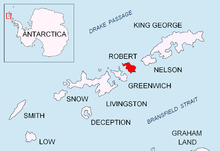
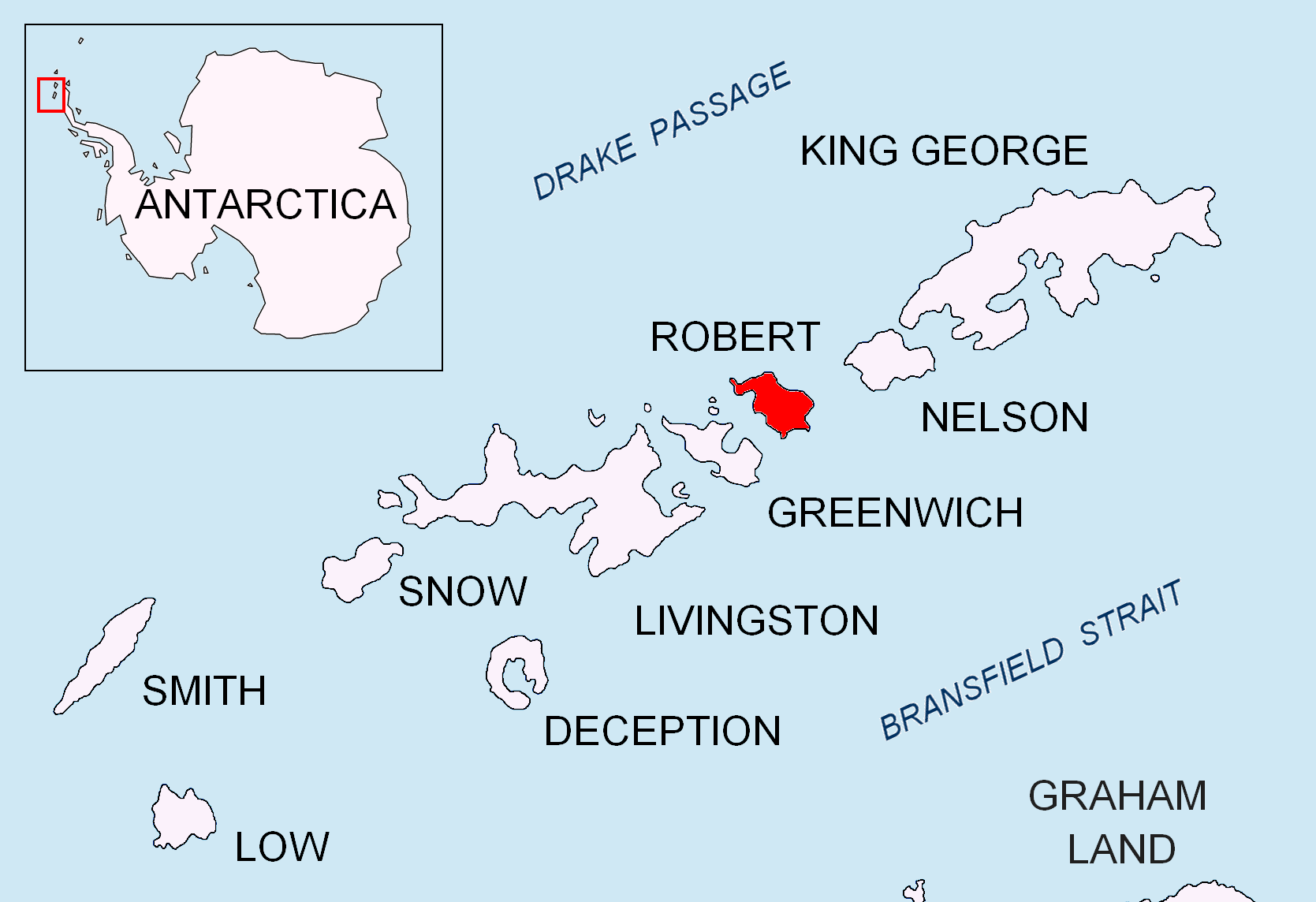
Location of Robert Island in the South Shetland Islands.Geography Location Antarctica Coordinates 62°21′07″S 59°41′00″W / 62.35194°S 59.6833333°W Archipelago South Shetland Islands Area 21 ha (52 acres)[1] Country Demographics Population 0 Additional information Administered under the Antarctic Treaty System Onogur Islands (Bulgarian: Оногурски острови, ‘Onogurski ostrovi’ o-no-'gur-ski 'os-tro-vi) is the group of nine islands and some islets and rocks adjacent to the northwest coast of Robert Island in the South Shetland Islands, Antarctica. Situated between Carlota Cove to the southwest and Clothier Harbour to the northeast, and 700 m (770 yd) southeast of Cornwall Island. The surface areas of the largest two islands are 11 hectares (27 acres) and 10 hectares (25 acres) respectively.[1]
The island group is named after the settlement of Onogur in northeastern Bulgaria in connection with the Onogur Bulgars (5th-7th century).
Contents
Location
Onogur Islands are located at 62°21′07″S 59°41′00″W / 62.35194°S 59.6833333°W. British mapping in 1822 and 1968, Chilean in 1971, Argentine in 1980, and Bulgarian in 2009.
See also
- Composite Antarctic Gazetteer
- List of Antarctic islands south of 60° S
- SCAR
- Territorial claims in Antarctica
References
- ^ a b L.L. Ivanov. Antarctica: Livingston Island and Greenwich, Robert, Snow and Smith Islands. Scale 1:120000 topographic map. Troyan: Manfred Wörner Foundation, 2009. ISBN 978-954-92032-6-4
External links
This article includes information from the Antarctic Place-names Commission of Bulgaria which is used with permission.
South Shetland Islands Major Minor - Aitcho
- (Barrientos
- Bilyana
- Cecilia
- Emeline
- Jorge
- Kilifarevo
- Pasarel
- Riksa)
- Araguez
- Astor
- Barlow
- Basso
- Bridgeman
- Chiprovtsi
- Cornwall
- Cornwallis
- Craggy
- Dee
- Desolation
- Dunbar
- (Aspis
- Balsha
- Zavala)
- Express
- Gibbs
- González
- Half Moon
- Heywood
- Kabile
- Meade
- (Zverino
- Cave)
- Miladinovi
- Montufar
- Ongley
- Onogur
- Penguin
- Pordim
- Pyramid
- Rogozen
- Romeo
- Rowett
- Rugged
- San Telmo
- Seal
- Sierra
- Stoker
- Table
- Tatul
- Treklyano
- Valchedram
- Window
- Withem
- Wood
- Zed
- (Esperanto
- Koshava
- Lesidren
- Phanagoria)
Rocks, stacks, reefs
spits and banks- Alepu
- Avren
- Belchin
- Bonert
- Bowler
- Buchino
- Caraquet
- Chaos
- Channel
- Chapman
- Cheshire
- Cone
- Cutler
- Dovizio
- Eddystone
- Eliza
- Folger
- Frederick
- Galiche
- Grace
- Graovo
- Henfield
- Hetty
- Holmes
- Ibar
- Koynare
- Letelier
- Liberty
- Lientur
- Long
- Lynx
- Maglizh
- Makresh
- Mellona
- Milev
- Mónica
- Morris
- Okol
- Opaka
- Orsoya
- Parry Patch
- Passage
- Pig
- Potmess
- Priboy
- Rabisha
- Raquelia
- Reyes
- Rongel
- Rosales
- Rusokastro
- Salient
- Sally
- Sewing-Machine Needles
- Skrino
- Stackpole
- Telish
- The Pointers
- Tooth
- Turmoil
- Tvarditsa
- Vardim
- Vergilov
- Vietor
- Voluyak
- Weeks

This South Shetland Islands location article is a stub. You can help Wikipedia by expanding it.