- Øystre Slidre
-
Øystre Slidre kommune — Municipality — Buahaugen in Øystre Slidre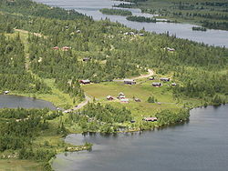
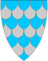
Coat of arms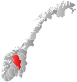
Oppland within
NorwayØystre Slidre within Oppland
Coordinates: 61°14′11″N 9°8′37″E / 61.23639°N 9.14361°ECoordinates: 61°14′11″N 9°8′37″E / 61.23639°N 9.14361°E Country Norway County Oppland District Valdres Administrative centre Heggenes Government – Mayor (2003) Gro Lundby (Ap) Area – Total 963 km2 (371.8 sq mi) – Land 881 km2 (340.2 sq mi) Area rank 109 in Norway Population (2004) – Total 3,116 – Rank 264 in Norway – Density 4/km2 (10.4/sq mi) – Change (10 years) 0.5 % Demonym Øystreslidring[1] Time zone CET (UTC+1) – Summer (DST) CEST (UTC+2) ISO 3166 code NO-0544 Official language form Nynorsk Website www.oystre-slidre.kommune.no Data from Statistics Norway Øystre Slidre is a municipality in Oppland county, Norway. It is part of the traditional region of Valdres. The administrative centre of the municipality is the village of
The old municipality of Slidre (created in 1838) was divided into Øystre Slidre and Vestre Slidre in 1849. The majority of today's residents live in the villages of Heggenes, Rogne, Skammestein, Beito, and Beitostølen.
Contents
General information
Name
The municipality (originally the parish) is named after the old Slidre farm (Old Norse: Slíðrar), since the first church was built here. The name is probably derived from slíðr which means "sheath" (which is probably referring to a long depression near the church). The meaning of the name Øystre Slidre is "(the) eastern (part of) Slidre" (since the parish and municipality of Slidre was divided in 1849.)[2]
See also: Vestre SlidreCoat-of-arms
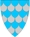
The coat-of-arms is from modern times. They were granted in 1989. The arms show blue and silver tiles made of slate. This recognizes that the slate industry was a formerly important industry in the area. Slate roofing was very common in Valdres.[3][4]
History
 Bitihorn and Båtskaret (the boat pass)
 At Røyne, looking towards Hegge
Båtskaret (The boat pass) is a narrow pass along Bitihorn where in medieval times people from Øystre Slidre dragged their boats through, therefore the name. A bit further into the mountain there is a big lake called Vinstervatnet with a lot of fine trout. As a result of a dispute between people from Valdres and people from Gudbrandsdal, they could not leave their boats behind. Therefore they had to resort to dragging their boats through Båtskaret. According to local folklore, the dispute began in medieval times with a young bride being married to an old man and a knight stealing his way over the mountains to rescue her. [4]
Hegge stave church, at Hegge, was originally constructed in the year 1216 or slightly later. It has been extensively rebuilt and is mostly post-reformation. It contains a fine altarpiece (reredos) carved by Kjørn from Heidal between 1781-1782.[4]
Geography
Øystre Slidre shares borders with the municipalities of Nord-Aurdal and Vestre Slidre in the south, Vang in the west, Gausdal, Sør-Fron, and Nord-Fron to the east, and up to Valdresflya, at the border of Vågå in the north. Øystre Slidre is part of the traditional district of Valdres in central, southern Norway, situated between the valleys of Gudbrandsdal and Hallingdal. Øystre Slidre is 45.1 kilometres (28.0 mi) on a north-south axis and 39.8 kilometres (24.7 mi) on an east-west axis.
The highest point is Øystre Rasletind at a height of 2,010 metres (6,590 ft) above sea level. About 73% of the land is over 900 metres (3,000 ft) in elevation. More than 10% of the land is over 1,300 metres (4,300 ft) above sea level. The lowest points lie at 410 metres (1,350 ft) above sea level. Lakes and rivers cover 75 square kilometres (29 sq mi) of the area. The largest lakes are Vinstri, Yddin, Vangsjøen, Javnin and Olevatn.[3]
Economy
Because of the rugged landscape, farming is only possible on a small scale, but this is still one of the main sources of income. There are only about 30 square kilometres (12 sq mi) of agricultural land in the municipality. About 85% of farmers in the municipality use the high mountain pastures in the summer time.[3]
 Beitostølen, view towards town centre
The winter sports resort of Beitostølen, host to World Cup events in biathlon and cross-country skiing, is located here. It is the biggest tourist area in the municipality, and provides a large fraction of the municipality's income.
References
- ^ "Personnemningar til stadnamn i Noreg" (in Norwegian). Språkrådet. http://www.sprakrad.no/nb-no/Sprakhjelp/Rettskrivning_Ordboeker/Innbyggjarnamn/.
- ^ Rygh, Oluf (1900). Norske gaardnavne: Kristians amt (Anden halvdel) (4 ed.). Kristiania, Norge: W. C. Fabritius & sønners bogtrikkeri. pp. 285. http://books.google.com/books?id=jJMOAAAAYAAJ. (Norwegian)
- ^ a b c "Om Øystre Slidre". Øystre Slidre kommune. http://www.oystre-slidre.kommune.no/artikkel.aspx?MId1=1&AId=22&back=1. Retrieved 2009-01-04. (Norwegian)
- ^ a b c Stagg, Frank Noel (1956). East Norway and its Frontier. George Allen & Unwin, Ltd..
External links
- Municipal fact sheet from Statistics Norway
- Oppland travel guide from Wikitravel
- Valdres travel guide from Wikitravel
- Official website (Norwegian)
- Beitostølen Resort (Norwegian)
Municipalities of Oppland Categories:- Municipalities of Oppland
- Valdres
- Øystre Slidre


Wikimedia Foundation. 2010.