- Nord-Aurdal
-
Nord-Aurdal kommune — Municipality — View over Strandefjorden, with Fagernes to the right
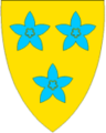
Coat of arms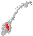
Oppland within
NorwayNord-Aurdal within Oppland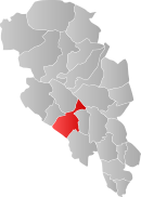
Coordinates: 60°57′35″N 9°15′51″E / 60.95972°N 9.26417°ECoordinates: 60°57′35″N 9°15′51″E / 60.95972°N 9.26417°E Country Norway County Oppland District Valdres Administrative centre Fagernes Government - Mayor (2003) Svein Erik F. Hilmen (Sp) Area - Total 907 km2 (350.2 sq mi) - Land 850 km2 (328.2 sq mi) Area rank 122 in Norway Population (2004) - Total 6,539 - Rank 151 in Norway - Density 8/km2 (20.7/sq mi) - Change (10 years) -0.9 % Demonym Nordaurdøl[1] Time zone CET (UTC+1) - Summer (DST) CEST (UTC+2) ISO 3166 code NO-0542 Official language form Neutral Website nord-aurdal.kommune.no Data from Statistics Norway Nord-Aurdal is a municipality in Oppland county, Norway. It is part of the traditional region of Valdres. The administrative centre of the municipality is the village of Fagernes.
The parish of Nordre Aurdal was established as a municipality on 1 January 1838 (see formannskapsdistrikt). The area of Nordre Etnedal was transferred from Nord-Aurdal to the neighboring municipality of Etnedal on 1 January 1894.
The municipality is served by Fagernes Airport, Leirin. In Nord-Aurdal, there is an alpine skiing center called Valdres Alpinsenter.
Contents
General information
Name
The Old Norse form of the name was Aurardalr. The first element is the genitive case of an old river name Aur (now called Bøaelva) and the last element is dalr which means "valley" or "dale". The old river name is derived from aurr which means "gravel". The name was changed from Nordre- to Nord- Aurdal in the early 20th century. Both nordre and nord mean "north", so the name Nord-Aurdal means "(the) northern (part of) Aurdal". (The parish of Aurdal was divided in 1805.)[2]
Coat-of-arms
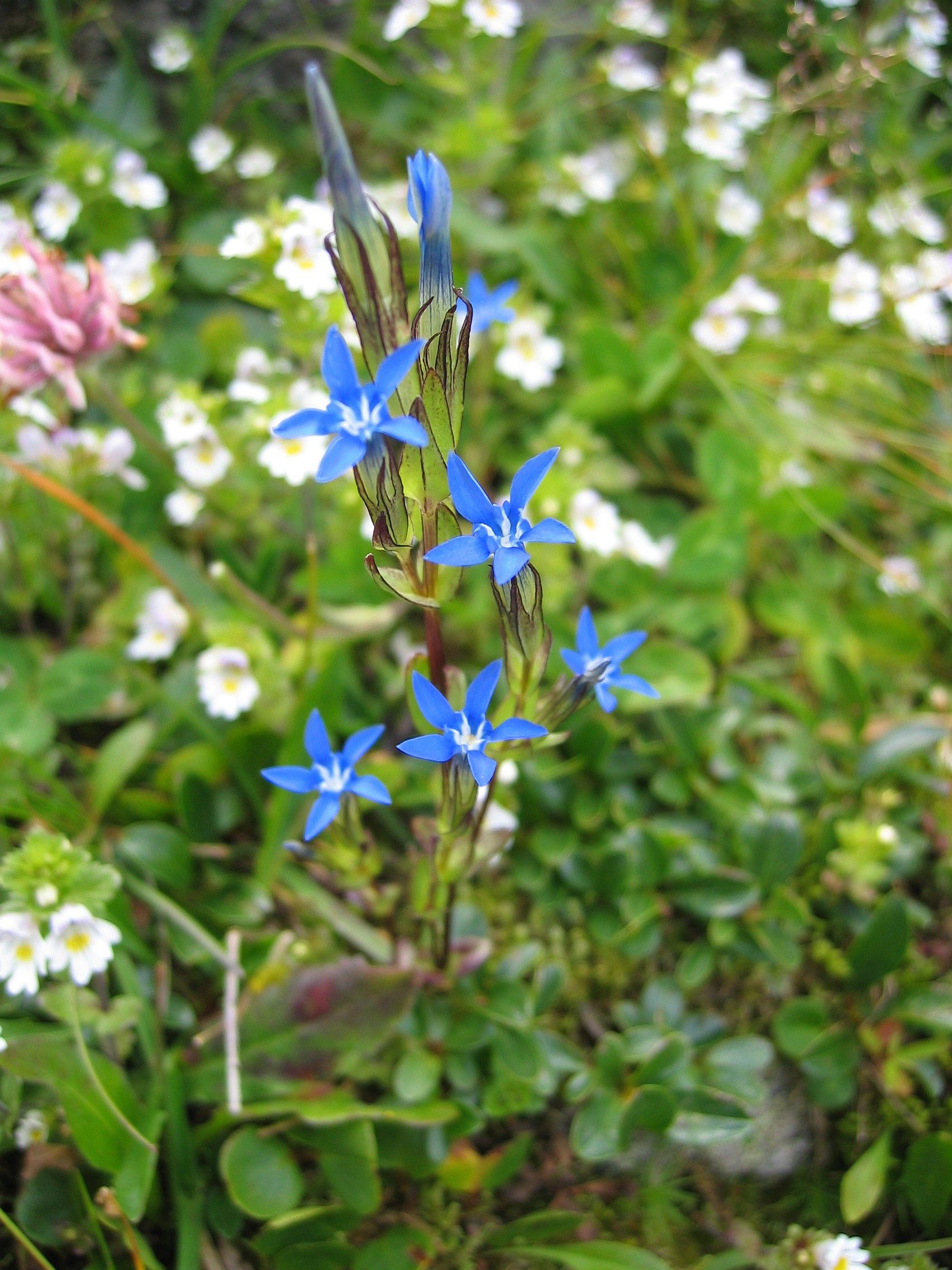
 Gentiana nivalis
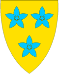
The coat-of-arms is from modern times. They were granted by royal degree on 20 December 1985. The arms show three blue flowers of the species Gentiana nivalis (or Snow Gentian) on a yellow background. The flowers, which are locally known as "the blue eyes of Christ", grow abundantly in the area. Three flowers were chosen to represent the three main settlements of the municipality: Aurdal, Fagernes, and Leira. This type of flower only opens in sunlight and heat, so it was chosen to symbolize being open and positive.[3][4]
Geography
Nord-Aurdal municipality is located north of Sør-Aurdal municipality, east of Etnedal and Gausdal municipalities, and south of Øystre Slidre and Vestre Slidre municipalities in Oppland county. To the west, it is bordered by Hemsedal and Gol in Buskerud county. Nord-Aurdal is 52.4 kilometres (32.6 mi) on the north-south axis and 43.3 kilometres (26.9 mi) on the east-west axis.
The municipality lies in the western side of Oppland county. Although Fagernes is the administrative center of Nord-Aurdal, the village of Aurdal was the administrative center for the former municipality of Aurdal. Nord-Aurdal is part of the traditional district of Valdres in the central part of southern Norway, situated between the valleys of Gudbrandsdal and Hallingdal.
The highest point in Nord-Aurdal is the Duptjernkampen at 1,325 metres (4,347 ft). About 50% of the land is above 900 metres (3,000 ft). The Tisleifjorden and Aurdalsfjorden are large inland lakes that are located in Nord-Aurdal.
Attractions
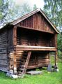
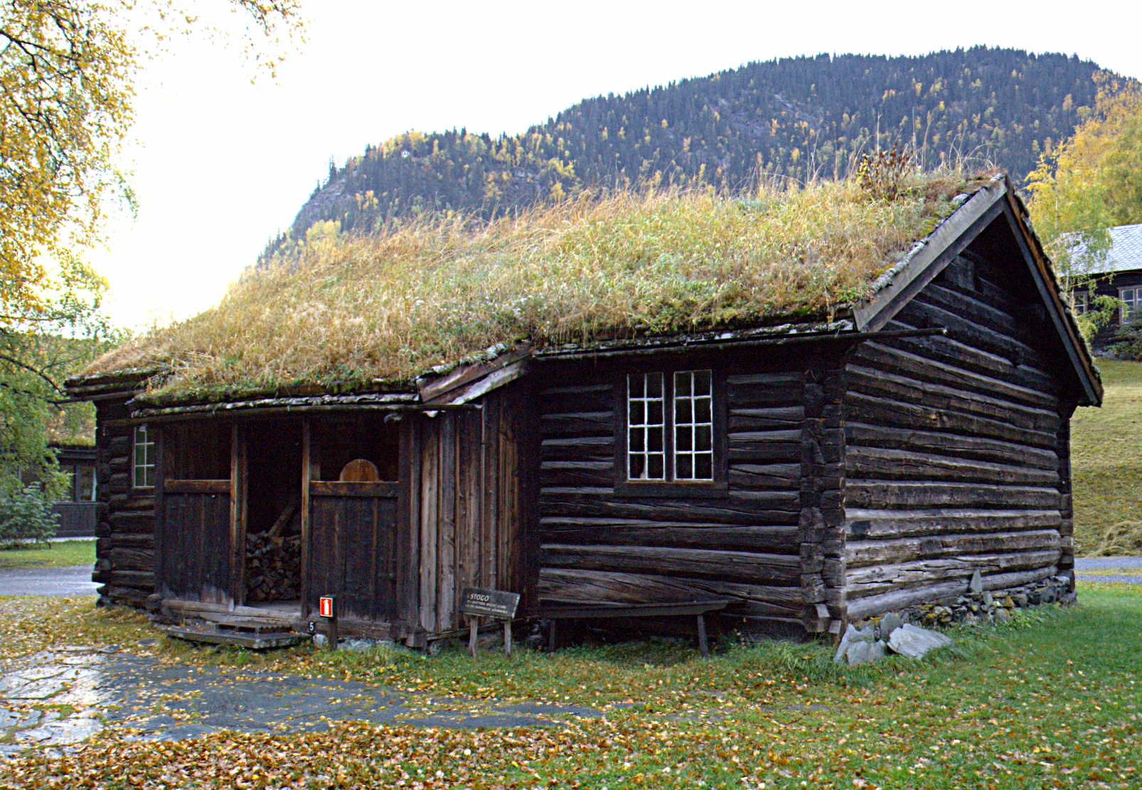
Valdres Folkemuseum is located just outside Fagernes and has large collections of old houses, textiles, and music instruments.
-

Valdres Folkemuseum
-
Valdres Museum
-

Skattebustugu
Notable residents
- Knut Hamsun, writer, see NRK, Dagbladet, and Aftenposten
- James C. M. Hanson (1864–1943), American librarian and author.[5]
International relations
Main article: List of twin towns and sister cities in NorwayTwin towns — Sister cities
The following cities are twinned with Nord-Aurdal:[6]
 - Kouvola, Etelä-Suomi, Finland
 - Lidköping, Västra Götaland County, Sweden
 - Skanderborg, Region Midtjylland, Denmark
References
- ^ "Personnemningar til stadnamn i Noreg" (in Norwegian). Språkrådet. http://www.sprakrad.no/nb-no/Sprakhjelp/Rettskrivning_Ordboeker/Innbyggjarnamn/.
- ^ Rygh, Oluf (1900). Norske gaardnavne: Kristians amt (Anden halvdel) (4 ed.). Kristiania, Norge: W. C. Fabritius & sønners bogtrikkeri. pp. 251. http://books.google.com/books?id=jJMOAAAAYAAJ. (Norwegian)
- ^ Norske Kommunevåpen (1990). "Nye kommunevåbener i Norden". http://www.ngw.nl/int/nor/n/nordaurd.htm. Retrieved 2009-01-04.
- ^ "Kommunevåpenet for Nord-Aurdal". Nord-Aurdal kommune. http://www.nord-aurdal.kommune.no/artikkel.aspx?MId1=1&AId=138&back=1. Retrieved 2009-01-04. (Norwegian)
- ^ James Christian Meinich Hanson (Odd Lovell. Store norske leksikon
- ^ "Vennskapsbyer". Nord-Aurdal kommune. http://www.nord-aurdal.kommune.no/Artikkel.aspx?AId=36&back=1&MId1=21&MId2=66&MId3=67. Retrieved 2009-01-04. (Norwegian)
External links
- Municipal fact sheet from Statistics Norway
- Oppland travel guide from Wikitravel
- Valdres travel guide from Wikitravel
- Valdresen - The local newspaper in Nord-Aurdal.
- Valdres Alpinsenter
Municipalities of Oppland Dovre · Etnedal · Gausdal · Gjøvik · Gran · Jevnaker · Lesja · Lillehammer · Lom · Lunner · Nord-Aurdal · Nord-Fron · Nordre Land · Østre Toten · Øyer · Øystre Slidre · Ringebu · Sel · Skjåk · Søndre Land · Sør-Aurdal · Sør-Fron · Vågå · Vang · Vestre Slidre · Vestre TotenCategories:- Municipalities of Oppland
- Valdres
-


Wikimedia Foundation. 2010.