- Vang, Oppland
Infobox_Kommune
name=Vang
idnumber=0545
county=Oppland
landscape=Valdres
capital=Vang i Valdres
governor=Knut O. Haalien (Sp)
governor_as_of=2003
arearank=50
area=1505
arealand=1311
areapercent=0.46
population_as_of=2004
populationrank=360
population=1,616
populationpercent=0.04
populationdensity=1
populationincrease=-7.4
language=Nynorsk
lat_deg=61| lat_min=12| lat_sec=52| lon_deg=8| lon_min=30| lon_sec=15
utm_zone=32V| utm_northing=6786796 |utm_easting=0473366| geo_cat=adm2nd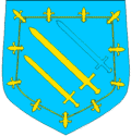
munwebpage=www.vang.kommune.noVang is a municipality in the county of
Oppland , Norway.Vang was established as a municipality January 1, 1838 (see
formannskapsdistrikt ).The name
The municipality (originally the parish) is named after the old farm Vang (Norse "Vangr"), since the first church was built here. The name is identical with the word "vangr" m 'field, meadow'.
Coat-of-arms
The coat-of-arms was made official in 1987 - but originally it belonged to a Middle Age nobleman from the district (
Sigvat på Leirhol ).Geography
Vang is bordered to the north by the municipalities Lom and
Vågå , to the east byØystre Slidre , to the southeast byVestre Slidre and to the south byHemsedal in the county ofBuskerud , to the west byLærdal andÅrdal in the county ofSogn og Fjordane .Vang is part of the
Valdres region in central, southernNorway . This region is situated betweenGudbrandsdal andHallingdal .Vang municipality is 56 km on a north-south axis and 47.3 km on an east-west axis. The highest point is Kalvehøgdi with a height of 2208 meters above sea-level.
Three quarters of the region is above 900 meters. Five percent of the area is covered by water. The lowest point is 363 meters above sea-level.
History
Vang, like the rest of Valdres, was originally populated by migrants from
Vestlandet . In 1153, recognizing this, Cardinal Breakspear included these valleys in the diocese of Stavanger.The ancient church of Vang was the site of a legal court (thing) held by Haakon VI in 1368. Here, he settled a boundary dispute. The boundary stone which resulted stands to this day.
High up the slopes of
Filefjell is the site of Nystua, where travellers found refuge as they passed across the divide intoVestlandet . On the other side of the pass, Maristua was erected at the direction of Queen Margaret circa 1390. Although Nystua is first mentioned in 1627, it is undoubtedly older. These refuges were maintained by the state until 1830."Smeddalen" (Smith's Valley) immediately to the west of Nystua, was for centuries the site of the church of St. Thomas ("St. Thomas på Filefjell"). The earliest reference to it is in 1615, but it was apparently a stave church, so would have been much older. According to F.N. Stagg “It was reconditioned (c. 1615)… the priest at Vang preached there once a year–on July 2nd… many sought cures for their ailments in the miraculous powers possessed by splinters from its timbers…” A market grew up near the church as a result of the July 2nd service. “Horses were traded, races run, heavy drinking indulged in and many a fight ensued.” Markets continued to be held near the church until the 19th century, but as a result of fighting and general unrest in connection with the market days the church was torn down in 1808. A new church was built on the site in 1971.
What to see
*
Høre stave church (built1180 )
*Øye stave church (built1150 -1200 )
*TheVang stone
*The Ryfossen waterfall
*The Sputrefossen waterfall
*St. Thomas Church, Filefjell ee also
*
Vang stave church References
"East Norway and its Frontier" by Frank Noel Stagg, George Allen & Unwin, Ltd. 1956
External links
* [http://www.vang.kommune.no Vang homepage]
* [http://www.vinjerock.no Vinjerock]
Wikimedia Foundation. 2010.