- Wikwemikong Unceded Indian Reserve
-
Coordinates: 45°42′46″N 81°42′22″W / 45.712892°N 81.706009°W
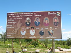
Wikwemikong — Reserve — Wikwemikong Unceded Indian Reserve Welcome sign Nickname(s): Wiky Country  Canada
Province  Ontario
District Manitoulin Government – Type First Nation – Chief Hazel Fox – Governing Body – MP Carol Hughes (NDP) – MPP Michael Mantha (NDP) Area – Land 412.97 km2 (159.4 sq mi) Population (2006)[1] – Total 2,387 – Density 5.8/km2 (15/sq mi) Time zone EST (UTC-5) – Summer (DST) EDT (UTC-4) Postal code span P0P 2J0 Area code(s) 705 Website www.wiky.net Wikwemikong Unceded Indian Reserve (usually known as Wikwemikong or Wiky) is an Indian reserve in the north-eastern section of Manitoulin Island in Manitoulin District, Ontario, Canada. Wikwemikong is an unceded Indian reserve in Canada, which means that it has not "relinquished title to its land to the government by treaty or otherwise."
The name Wikwemikong means "bay of beavers".
The reserve is occupied by Ojibwa, Odawa and Potawatomi peoples, under the Council of Three Fires. The current band chief is Hazel Fox.
Contents
Geography
Wikwemikong occupies a large peninsula on the eastern end of Manitoulin Island, which is connected to the rest of the island by an isthmus separating South Bay from Manitowaning Bay. The reserve's primary access is via Wikwemikong Way, which continues off the reserve as Cardwell Street and connects to Highway 6 at Manitowaning.
The smaller Point Grondine reserve, located on the mainland near Killarney, also belongs to the Wikwemikong band.
History
From 1836 to 1862, the entirety of Manitoulin Island was set aside as the "Manitoulin Island Indian Reserve" under the Bond Head Treaty. The most important of the pre-confederation treaties were the Robinson Treaties because all subsequent treaties were modelled after these. In 1850, William B. Robinson, a government negotiator and former fur trader, proposed that First Nations reserves be created on the Crown Land acquired through treaties. These Reserves were intended to be the answer to what the immigrant settlers needed for land settlement. First Nation peoples would be set apart on reserves from the new settlers. The Robinson-Huron and Robinson-Superior treateies were signed in September 1850 for large territories north of the two Great Lakes.
According to written records, Lake Huron and Lake Superior area leaders surrendered nearly 15 000 000 heactares of land in exchange for the establishment of 24 reserves and a payment of approximately $10 000 to be followed by additional annual payment of $2700. However, First Nations leaders were led to believe that the agreement was to share the land with the colonists and retain their rights to hunt and fish throughout the area.
Soon after, two other treaties were negotiated. These tracts of land were smaller, and the government (Canada) attempted to reduce the financial compensation offered with the two treaties - the Saugeen First Nation in 1854 and the Manitoulin First Nation in 1864. Several leaders, Jesuit missionaries, and the entire Odawa First Nations community refused to sign the deal for less money.
In 1862, most of the island was ceded to the government of Canada under the MacDougall Treaty for new settlement by non-natives, resulting in the creation of new reserves at West Bay, Sheguiandah, Sheshegwaning, Cockburn Island and Sucker Creek. However, two bands which occupied the land that now comprises Wikwemikong refused to sign the treaty, and thus continued to exist as a remnant of the Manitoulin Island Indian Reserve.
Wikwemikong as it exists today was created in 1968, when the two unceded bands and the Point Grondine band amalgamated as the Wikwemikong band.
Communities
In addition to the primary settlement at Wikwemikong, smaller settlements on the reserve include Buzwah, Kaboni, Maiangowi, Murray Hill, South Bay, Two O'Clock, Wabozominissing and Wikwemikonsing.
The reserve is served by four churches, two elementary schools and Wasse Abin High School.
Culture
The reserve is also home to the Wikwemikong Cultural Festival (Wikwemikong Pow Wow) which is held annually every Civic Holiday Weekend (first weekend in August).
This annual event is touted as the largest and oldest Pow Wow in Eastern Canada. Considered to be one of the major Pow Wows in North America, it is attended by many Aboriginal dancers who participate in competition of all age ranges, demonstrating Traditional, Grass, Jingle, and Fancy Dancing.
Wikwemikong is also home to a professional theatre company, De-ba-jeh-mu-jig Theatre Group, which stages and produces plays about First Nations life and culture..
People
Notable people from Wikwemikong include country music artist Crystal Shawanda, Federal Court of Canada judge Leonard S. Mandamin, former NHL player Chris Simon and artist Daphne Odjig.
External links

Manitowaning Bay / Northeastern Manitoulin and the Islands North Channel / Killarney 
Assiginack 
Georgian Bay  Wikwemikong Unceded

South Bay / Tehkummah Lake Huron Main Channel / North. Bruce Peninsula Manitoulin District, Ontario Towns Townships Assiginack • Billings • Burpee and Mills • Central Manitoulin • Cockburn Island • Gordon/Barrie Island • TehkummahIndian Reserves M'Chigeeng (West Bay) • Sheguiandah • Sheshegwaning • Sucker Creek • Whitefish River • Wikwemikong • Zhiibaahaasing (Cockburn Island)Unorganized terrtories Union of Ontario Indians Lake Superior Region Biinjitiwabik Zaaging (Rocky Bay) • Bingwi Neyaashi (Sand Point) • Fort William • Gull Bay • Long Lake 58 • Michipicoten • Namaygoosisagagun • Pays Plat • Pic Mobert • Pic River (Heron Bay) • Red Rock (Lake Helen) Lake Huron Region Atikameksheng (Whitefish Lake) • Aundeck-Omni-Kaning (Sucker Creek) • Dokis • Garden River • Henvey Inlet • Magnetawan • M'Chigeeng (West Bay) • Mississauga • Nipissing • Sagamok • Serpent River • Sheguiandah • Sheshegwaning • Thessalon • Wahnapitae • Wasauksing (Parry Island) • Whitefish River • Wikwemikong • Zhiibaahaasing (Cockburn) Southwest Region Aamjiwnaang (Sarnia) • Kettle & Stony Point • Munsee-Delaware • Thames Chippewa Southeast Region Alderville • Beausoleil (Christian Island) • Curve Lake • Georgina Island • Scugog Island • Moose Deer Point • Pikwàkanagàn Categories:- Union of Ontario Indians
- Communities in Manitoulin District, Ontario
- Anishinaabe reserves in Ontario
Wikimedia Foundation. 2010.

