- Ossington Avenue
-
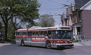 A TTC trolleybus on the Ossington route in 1987
Ossington Avenue is a main or arterial street in Toronto, Ontario, Canada, west of downtown. Originally part of a pioneer road built in 1812, it became an arterial road. Today it is becoming a night-life district with numerous bars and restaurants.
Contents
History
Ossington Avenue is named after the ancestral Nottingham home of the Denison family, early land-owners in the Ossington area. John Denison's 'Brookfield House' used to stand at the northwest corner of Ossington and Queen Street. Area streets Brookfield Street, Denison Avenue, Dovercourt Road, Heydon Park Road and Rusholme Road are all attributed to the Denison family.[1]
The first section of Ossington from Queen Street to Dundas Street was surveyed not long after the establishment of York in 1793. It was part of the original Dundas road, leading to London, Ontario. It was not until the War of 1812, that the road was built, after the Battle of York. During the 19th century, this section was developed as a commercial street. The Ontario Provincial Lunatic Asylum was opened at the foot of Dundas and Queen Street in 1850.[2]
By 1906, Ossington Avenue was built north from Dundas to St. Clair, as can be seen in the 1906 Canada Atlas. The street north of Dundas was built after the burying of the Garrison Creek which crossed Ossington north of Dundas, and the creek's route can still be seen in a lower area of land between Dundas and College. In the 20th century, Dundas Street was extended east to downtown Toronto, and the section of Dundas north of Queen was renamed Ossington. The section north of Davenport was eventually renamed to Oakwood Avenue, and the street currently ends at Davenport.
As Toronto expanded west and other retail facilities opened, the commercial section of Ossington south of Dundas became an area of industrial uses, including automotive repairs and storage facilities. By 2003, this area became known for crime and the known presence of Vietnamese criminal gangs and street drug peddlers. A double murder in a karaoke bar that year sparked neighbourhood action in concert with the police to cut down on crime.[3]
By 2007, the low rents of stores along Ossington became attractive after rents along the Queen Street West increased. This led to an influx of bars, restaurants and stores. By 2009, the number of bars and restaurants created tension with residents of the surrounding neighbourhood, and licensing controls were imposed to stop the opening of more businesses of the same kind.[4]
Character
Ossington starts at Queen Street and goes north, up a hill to Dundas Street. South of Queen is the Centre for Addiction and Mental Health's (CAMH) Queen Street Health Centre complex. From Shaw Street west to Dovercourt, the south side of Queen street is used for CAMH facilities. CAMH proposes to extend Ossington south into the complex.
From this intersection north to Dundas, Ossington is lined with low-rise retail storefronts, typically with apartments on upper floors. The businesses along here are mixed with older businesses such as automotive repairs and newer bars and restaurants. Many buildings along this stretch date to the 19th century, and many have been renovated in their conversion into restaurants and trendy stores. A number of bars, pubs and restaurants have opened up along this section of Ossington, which have attracted the hipsters subculture to the area.
North of Dundas, the street changes to a primarily residential street. The road slopes down here as it goes into the Garrison Creek ravine, (the creek is buried nowadays) then starts a gradual slope up to its terminus at Davenport. The homes are typically two-story detached or semi-detached homes. This stretch has streetcar tracks and is used by the TTC often for short-turns by the 504 Dundas and 505 College streetcar routes.
North of College, on the west side is Dewson Street public school. One block east on Shaw Street is Central Commerce Collegiate high school. The next street to connect is Harbord Street which goes east from Ossington to Queen's Park Circle. The area is residential on both sides of the street.
North of Bloor Street, the street rises gently until just before Davenport where it reaches the old shoreline and the street rises rapidly to meet Davenport. Except for some businesses around the railway bridge north of Dupont, both sides of the street are two-storey residences.
Transportation
Ossington Avenue is served by the 63 Ossington TTC bus route. The bus route connects to the Ossington subway station of the Bloor-Danforth subway line. Route 63 was a trolleybus route from December 1947[5] until January 1992, but since then has been served by conventional buses.
References
- ^ Wise/Gould, p. 46
- ^ "History of the Queen Street Site". CAMH. http://www.camh.net/News_events/Redeveloping_the_Queen_Street_site/History%20of%20the%20Queen%20Street%20Site/history_of_the_queen_street_site.html. Retrieved 2009-12-10.
- ^ "Electric Avenue". Toronto Life. May 2008. http://www.torontolife.com/features/electric-avenue/. Retrieved 2009-12-10.
- ^ "Ossington’s high noon". Now Toronto. http://www.nowtoronto.com/news/story.cfm?content=169776. Retrieved 2009-12-10.
- ^ Sebree, Mac; and Ward, Paul (1974). The Trolley Coach in North America, p. 327. Los Angeles: Interurbans. LCCN 74-20367.
- Wise Lenard; Gould, Allan (2000). Toronto street names: and illustrated guide to their origins. Willowdale, Ontario: Firefly Books. ISBN 1552093867.
External links
Major roads in Toronto North-south Bathurst · Bayview · Birchmount · Brimley · Browns Line · Dufferin · Islington · Jane · Keele · Kennedy · Kipling · Leslie · Markham · Martin Grove · McCowan · Morningside · Royal York · Victoria Park · Warden · Weston · Woodbine · YongeOther streetsAvenue/University · Bay · Black Creek · De Grassi · Jameson · Jarvis · John · Lansdowne · Mount Pleasant · Ossington · Palmerston · Parliament · Roncesvalles · Spadina · VaughanEast-west Concession roadsBloor/Danforth · Eglinton · Finch · Lawrence · Sheppard · St. Clair · Steeles · The Queensway/Queen West/Queen East · York MillsOther streetsCollege/Carlton · Dundas · Eastern · Front · Gerrard · King · Kingston · Lake Shore · Queen's Quay · RaymoreExpressways and highwaysRoads in Toronto on Wikimedia Commons · Roads in Ontario Categories:- Streets in Toronto

Wikimedia Foundation. 2010.