- Nunawading railway station
-
Nunawading 
Station information Code NWG Distance from
Flinders Street19.8 km Operator Metro Trains Melbourne Lines Belgrave,
Lilydale# Platforms 2 # Tracks 2 Status Premium station Metlink profile Link Melway map Link Google map Link Metcard / Myki Zone 2 Nunawading is a railway station on the Lilydale and Belgrave railway lines, in the suburb of Nunawading in Melbourne, Australia.[1] It is located in myki ticketing Zone 2, and has two platforms. Nunawading railway station has been upgraded to a Premium Station in 2010 along with the grade separation of Springvale Road, as outlined in the Victorian Transport Plan in December 2008.
The original station was closed on 18 December 2009 and was demolished, with a replacement station being built on the west side of Springvale Road.[2]
Space was provided in the replacement station, for a third track and platform which may be added in the future to run more services.
Contents
Facilities
The station is located approximately 8 m below ground and is located on the west side of Springvale Road. The station contains 2 platforms in an island style format and is a premium station which means that there are customer service staff who are available from the first to the last scheduled train service each day.
The station roof, styled as a canopy, features wooden panels and a large skylight in the middle made from the same materials as China's Watercube Aquatic Centre. It also feature bluestone pavers at the concourse level and graffiti proof stainless steel and glass finishes.
The station entry and ticketing and information office is located on street level on the city side of Springvale Road. Stairs and a lifts allow passengers to access the platforms which stretches from the west of Springvale Road. The station uses natural lighting to enhance the comfort, visibility and ambience. Other passenger amenities such as male, female and disabled toilets, CCTV cameras, bright security lighting, a sheltered waiting area and vending machines.
There is also a pedestrian underpass which allows access to the station and the bus interchange on the other side of Springvale Road. Lifts are installed on either side of Springvale Road to allow passengers who have difficulty using stairs to access the platforms and the bus interchange. The facilities at Nunawading station include: bicycle storage lockers and racks, a taxi rank and a drop-off and parking area at street level. Long term customer parking is also available along Walkers Road and Station Street. Community parking is also available in Silver Grove.
The citybound side of the station is located adjacent to a local shopping strip and is surrounded by factory outlets, homemaker and furniture stores and other large retail outlets along the Maroondah Highway.
Platforms, services and bus connections
Platform 1:
- Lilydale and Belgrave lines - limited stops services to Flinders Street
Platform 2:
- Lilydale and Belgrave lines - limited stops and all stations services to Ringwood, Lilydale, Mooroolbark, Upper Ferntree Gully and Belgrave.
History
Nunawading railway station was opened in 1888 and was originally named Tunstall station. It was renamed in 1945 when the area known as Tunstall was renamed Nunawading.[3] It initially served the clay and brick producers in the area and used to have bus services operating between the station and the former VFL Park, but these services ceased following to the ground's closure.
At Nunawading the railway line runs parallel to and just south of the Maroondah Highway, originally crossing Springvale Road at a level crossing. Boom barriers replaced hand gates at the crossing in 1956.[4] It was rated as Victoria's most dangerous level crossing with more than 125,000 cars crossing each day, and the RACV surveys in 2006 and 2008 named it as "the worst congestion point in the state". [5] A number of grade separation proposals were made over many years, including one for a station similar to Boronia station. In September 2008 a contract was awarded to provide a grade separation. The final scheme included the building of a new station on the west side of Springvale Road with realigned tracks passing under Springvale Road. The old station closed on 18 December 2009, the new one opening on 11 January 2010. The works cost around $120 million.[5]
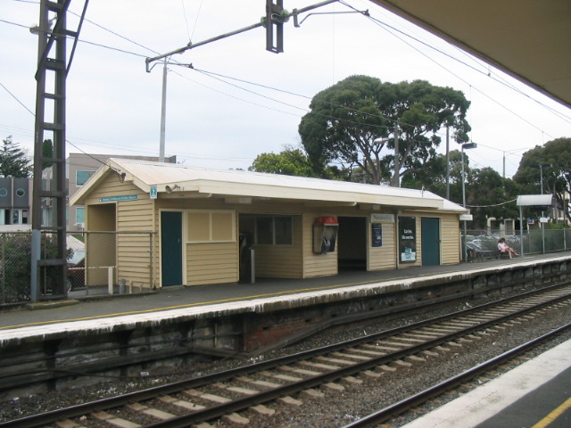
The former Nunawading railway station, now demolished, contained two platforms: platform one had a fibro station building resting on brick foundations, and platform two had a wooden building. A Telstra payphone was also located on platform two. There were three metcard ticket machines at the station, with two on the citybound side and one coin-only machine on the outbound platform. On the citybound side there was also a newspaper dispenser and a pair of vending machines. Outside of the citybound platform, there was also a self-maintaining public toilet. Semi-enclosed waiting facilities were provided on both platforms. Nunawading was one of few host stations that had an attended booking office in the morning peak period.
Gallery
-

The former station prior to demolition
References
- ^ Metlink:Nunawading Railway Station (Nunawading) - Train stop
- ^ Metlink: Closure of Nunawading Station from 8pm on Friday 18 December
- ^ VICSIG Infrastructure - Nunawading
- ^ VR History by Andrew Waugh
- ^ a b Clay Lucas (September 16, 2008). "Notorious crossing to be removed". The Age. http://www.theage.com.au/national/notorious-crossing-to-be-removed-20080915-4h3o.html. Retrieved 2008-09-16.
External links
Station Navigation Lilydale and Belgrave lines ← Previous Station Blackburn | Mitcham Next Station → Entire network Coordinates: 37°49′13″S 145°10′38″E / 37.8204°S 145.1771°E
Categories:- Railway stations in Melbourne
- Premium Melbourne railway stations
- Railway stations opened in 1888
Wikimedia Foundation. 2010.