- Northam (North Devon) railway station
-
Northam 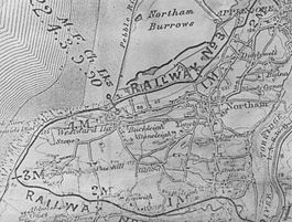
Map showing the position of Northam station Location Place Northam Area North Devon Operations Original company Bideford, Westward Ho! and Appledore Railway Pre-grouping British Electric Traction Platforms 1 History 20 May 1901[1][2] Opened 28 March 1917 Closed[3] Disused railway stations in the United Kingdom Closed railway stations in Britain
A B C D–F G H–J K–L M–O P–R S T–V W–ZNortham railway station was a railway station in North Devon, close to Appledore, serving the village of Northam, Parish of Northam; a community within the Appledore peninsula. It was 5 miles and 45 chains from Bideford.[4]
Contents
History
This was the terminus station on the line in 1901[4] prior to the extension to Appledore of 1908. The station stood a lttle way from the village of Northam. Many of the trevellers were golfers on their way to the links on the Burrows.[5]
Infrastructure
Northam had a shelter and one platform of 180 feet length on the down side of the line; [4] it originally had a short run round loop and a signal box and one semaphore signal,[4] however with the completion of the extension to Appledore in 1908 it was reduced to a single line without sidings or signalling.[4][6] The line, without gates, crossed Pimpley Road on the level before reaching the Richmond Road request halt.[4]
Micro history
In January 1901 a one carriage train ran from Bideford to Northam carrying a few friends of the Directors.[7]
Jack Shears, who lived at Northam, was one of the trackmen who worked to maintain the permanent way.[8]
No photographs appear to exist of Northam railway station.
The previous and next stations
Preceding station Historical railways Following station Beach Road Halt
Line closed; station closedBideford, Westward Ho! and Appledore Railway
Bideford to Westward Ho!, Northam and Appledore
Richmond Road
Line closed; station closedReferences
Notes;
Bideford, Westward Ho! and Appledore Railway Legend

Appledore 
Lovers Lane Halt Richmond Road Halt 
Northam Beach Road Halt Westward Ho! Cornborough Cliffs Halt Abbotsham Road Kenwith Castle Halt Causeway Crossing The Lane Halt Bideford Strand Halt 


0,0 Bideford Quay Bideford 
North Devon Railway Sources;
- Baxter, Julia & Jonathan (1980). The Bideford, Westward Ho! and Appledore railway 1901-1917. Pub. Chard. ISBN 0-9507330-1-6.
- Christie, Peter (1995). North Devon History. The Lazarus Press. ISBN 1-898546-08-8.
- Garner, Rod (2008). The Bideford, Westward Ho! & Appledore Railway. Pub. Kestrel Railway Books. ISBN 987-1-905505-09-8.
- Griffith, Roger (1969). The Bideford, Westward Ho! and Appledore Railway. School project and personal communications. Bideford Museum.
- Jenkins, Stanley C. (1993). The Bideford, Westward Ho! and Appledore Railway. Oxford : Oakwood Press. ISBN 0-85361-452-0.
- Stuckey, Douglas (1962). The Bideford, Westward Ho! and Appledore Railway 1901-1917. Pub. West Country Publications.
External links
Coordinates: 51°02′42″N 4°12′58″W / 51.0449°N 4.2161°W
Towns and villages in North Devon  Barbrook · Barnstaple · Berrynarbor · Braunton · Charles · Colleton · Combe Martin · Creacombe · Croyde · East Anstey · East Buckland · Filleigh · Fremington · Furzehill · Georgeham · Hele Bay · Ilfracombe · Instow · Kentisbury · Knowle · Knowstone · Landkey · Lee · Lee Bay · Lynmouth · Lynton · Malmsmead · Meshaw · Mortehoe · Oldways End · Parracombe · Rackenford · Roachill · Saunton · Shallowford · Week · West Down · West Lynn · Westward Ho! · Woolacombe · Wrafton · Yelland
Ceremonial county of Devon Unitary authorities Boroughs or districts Major settlements - Ashburton
- Axminster
- Barnstaple
- Bideford
- Bovey Tracey
- Bradninch
- Brixham
- Buckfastleigh
- Budleigh Salterton
- Chagford
- Chudleigh
- Chulmleigh
- Colyton
- Crediton
- Cullompton
- Dartmouth
- Dawlish
- Exeter
- Exmouth
- Great Torrington
- Hartland
- Hatherleigh
- Holsworthy
- Honiton
- Ilfracombe
- Ivybridge
- Kingsbridge
- Kingsteignton
- Lynton
- Modbury
- Moretonhampstead
- Newton Abbot
- North Tawton
- Northam
- Okehampton
- Ottery St Mary
- Paignton
- Plymouth
- Plympton
- Princetown
- Salcombe
- Seaton
- Sidmouth
- South Molton
- Tavistock
- Teignmouth
- Tiverton
- Torquay
- Totnes
See also: List of civil parishes in Devon
Rivers Topics - Devon County Council
- Economy
- Flag
- History
- Notable people
- Dartmoor
- Exmoor
- Jurassic Coast
- Towns by population
- South West Coast Path
- Museums
Categories:- Railway stations opened in 1901
- Railway stations closed in 1917
- Seaside resorts in England

Wikimedia Foundation. 2010.