- Charles, Devon
-
Coordinates: 51°06′00″N 3°53′00″W / 51.100000°N 3.8833331°W
Charles 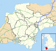
 Charles
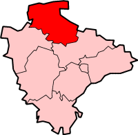
Charles shown within DevonOS grid reference SS6822935098 District North Devon Shire county Devon Region South West Country England Sovereign state United Kingdom Post town SOUTH MOLTON Postcode district EX32 7 Dialling code 01769 Police Devon and Cornwall Fire Devon and Somerset Ambulance South Western EU Parliament South West England UK Parliament North Devon List of places: UK • England • Devon Charles is a hamlet in the civil parish of East Buckland in the North Devon district of Devon, England. Its nearest town is South Molton, which lies approximately 4.7 miles (7.6 km) south-east from the hamlet, just off the A399 road.
Towns and villages in North Devon 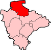 Barbrook · Barnstaple · Berrynarbor · Braunton · Charles · Colleton · Combe Martin · Creacombe · Croyde · East Anstey · East Buckland · Filleigh · Fremington · Furzehill · Georgeham · Hele Bay · Ilfracombe · Instow · Kentisbury · Knowle · Knowstone · Landkey · Lee · Lee Bay · Lynmouth · Lynton · Malmsmead · Meshaw · Mortehoe · Oldways End · Parracombe · Rackenford · Roachill · Saunton · Shallowford · Week · West Down · West Lynn · Westward Ho! · Woolacombe · Wrafton · YellandCategories:
- Devon geography stubs
- Hamlets in Devon

Wikimedia Foundation. 2010.