North West Slopes

North West Slopes
North West Slopes
New South Wales
Nw slopes NSW.png
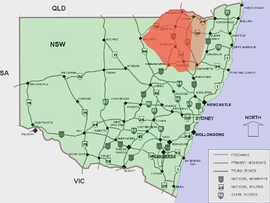
Approximate area of the North West Slopes
LGA:
Federal Division: Parkes

The North West Slopes region of New South Wales, Australia refers generally to the area west of the Northern Tablelands, to the north of the Central West region and to the east of the Far West region. The region corresponds generally to the Australian Bureau of Meteorology's forecast area of North West Slopes and Plains. [1]

It is higher, hillier and wetter on its eastern edge than on its western edge. The North West Slopes are situated on various tributaries to the Darling River, which rise in the Great Dividing Range country to its east, such as the Barwon, Gwydir, and Namoi Rivers.

The North West Slopes includes the towns of Gunnedah, Warialda, Manilla, Boggabri, Mungindi, Narrabri, Moree, Quirindi, Wee Waa, the city of Tamworth and many villages.[2]

It has traditionally been a major wheat-growing area, but in recent decades irrigated crops, especially cotton, have become significant. The primary exports are cotton, coal, beef, lamb and pork, cereal and oilseed grains.

The North West region is traversed by the New England Highway, Newell Highway, the Kamilaroi Highway, Oxley Highway and the Gwydir Highway and by railways such as the Main Western railway line, linking Bourke to Sydney with connections to the port of Newcastle. The Main North railway line trains no longer continue to the Queensland border, but Werris Creek, Tamworth and Kootingal are still served by the Countrylink Xplorer service between Sydney and Armidale.

Mount Kaputar National Park, near Narrabri, is within the North West Slopes region.

This region is often included as part of the New England region. Sometimes the region is also known as the New England North West[3] or less commonly the Northern Inland Region[4] when it also includes the Northern Tablelands.

Local Government Areas (LGA) include Gunnedah Shire, Liverpool Plains Shire, Moree Plains Shire, Narrabri Shire, Gwydir Shire and Tamworth Regional Council.

See also

References

  1. ^ "Forecast areas". Bureau of Meteorology. http://www.bom.gov.au/weather/nsw/nsw-forecast-map.shtml. Retrieved 2006-11-06. 
  2. ^ New South Wales Forecast Areas Map Retrieved on 2009-10-14
  3. ^ New England North West Retrieved 2009-9-27
  4. ^ Northern Inland Region Retrieved 2009-10-7

External links


Wikimedia Foundation. 2010.

Игры ⚽ Поможем написать реферат

Look at other dictionaries:

  • North West Slopes — Les North West Slopes. La Région des North West Slopes (littéralement des versants Nord Ouest) en Nouvelle Galles du Sud en Australie correspond généralement à la région limitée à l est par la Northern Tablelands, au sud par la région Centre… …   Wikipédia en Français

  • North West Slopes (New South Wales) — Infobox Australian Place | type = region name = North West Slopes state = New South Wales caption = Approximate area of the North West Slopes pop = area = est = url = stategov = fedgov = lga = Moree Plains Shire Council lga2 = Inverell Shire… …   Wikipedia

  • North West (South African province) — North West Province redirects here. For other similarly named provinces, see Northwestern Province. North West Bokone Bophirima (Tswana) Noordwes (Afrikaans)   Province …   Wikipedia

  • South West Slopes — est une des 15 régions de la Nouvelle Galles du Sud en Australie. Elle s étend sur la partie basse de la Cordillère australienne. Elle est encadrée au nord par la Central West, à l ouest par la Riverina, au sud par l État de Victoria et à l est… …   Wikipédia en Français

  • North-West Frontier Province — Pakistan infobox region = North West Frontier Province capital = Peshawar latd = 34.00 longd = 71.32 pop year = 2008 population = 20,215,000 (Estimate) density km2 = 259.6 area km2 = 74,521 languages = Pashto (official) Hindko Khowar Punjabi… …   Wikipedia

  • North-West Frontier Province — /nawrth west , west / a province in Pakistan, bordering Punjab and Kashmir on the west: a former province of British India. 10,885,000; 28,773 sq. mi. (77,516 sq. km). Cap.: Peshawar. * * * ▪ province, Pakistan Introduction       northernmost… …   Universalium

  • ABC New England North West — Radio station name = ABC New England North West callsign = 2NU airdate = 1948 frequency = 648 kHz AM New England 819 kHz AM Northern Tablelands 99.1 mHz FM North West Slopes 101.9 mHz FM Armidale area = New England, Australia owner = Australian… …   Wikipedia

  • South West Slopes (New South Wales) — The South West Slopes is a region predominantly in New South Wales, Australia. It covers the lower inland slopes of the Great Dividing Range extending from north of Cowra through southern NSW into western Victoria. More than 90% of the region is… …   Wikipedia

  • Hartbeespoort, North West — Hartbeespoort is a small resort town in the North West Province of South Africa, situated on slopes of the Magaliesberg mountain and the banks of the Hartbeespoort Dam. The name of the town means pass of the hartbees (a species of antelope) in… …   Wikipedia

  • North Shore Mountains — Range A view of the North Shore Mountains as seen looking west from the Mount Seymour alpine area in March. The obvious sh …   Wikipedia

Share the article and excerpts

Direct link
Do a right-click on the link above
and select “Copy Link”