North West Slopes (New South Wales)
- North West Slopes (New South Wales)
Infobox Australian Place | type = region
name = North West Slopes
state = New South Wales
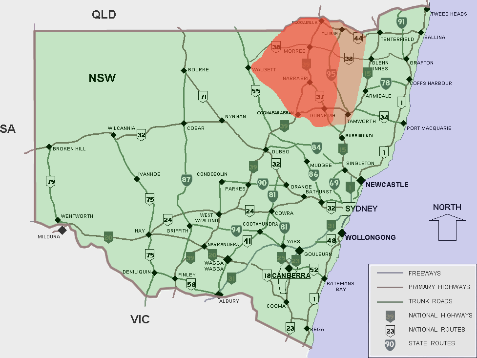
caption = Approximate area of the North West Slopes
pop =
area =
est =
url =
stategov =
fedgov =
lga = Moree Plains Shire Council
lga2 = Inverell Shire Council
lga3 = Narrabri Shire Council
lga4 = Gunnedah Shire CouncilThe North West Slopes region of New South Wales, Australia refers generally to the area to the west of New England region, to the north of the Central West region and to the east of the Far West region. The region corresponds generally to the Australian Bureau of Meteorology's forecast area of "North West Slopes and Plains". [cite web
title = Forecast areas
publisher = Bureau of Meteorology
url = http://www.bom.gov.au/weather/nsw/nsw-forecast-map.shtml
accessdate = 2006-11-06 ]
It is higher, hillier and wetter on its eastern edge than on its western edge. It is situated on various tributaries to the Darling River, which rise in the Great Dividing Range country to its east, such as the Barwon, Gwydir, and Namoi Rivers.
Its includes the towns of Gunnedah, Coonabarabran, Warialda, Narrabri and Moree and, arguably, Tamworth and Inverell (which are sometimes classed in New England, although they are much lower than the Northern Tablelands). It has traditionally been a major wheat-growing area, but in recent decades irrigated crops, especially cotton, have become significant.
The Central West region is traversed by the Newell Highway, the Kamilaroi Highway and the Gwydir Highway and by railways such as the Main Western railway line, linking Bourke to Sydney with connections to the port of Newcastle.
ee also
*Regions of New South Wales
References
Wikimedia Foundation.
2010.
Look at other dictionaries:
South West Slopes (New South Wales) — The South West Slopes is a region predominantly in New South Wales, Australia. It covers the lower inland slopes of the Great Dividing Range extending from north of Cowra through southern NSW into western Victoria. More than 90% of the region is… … Wikipedia
North Curl Curl, New South Wales — North Curl Curl Sydney, New South Wales North Curl Curl from Wingala Reserve Population … Wikipedia
North West Slopes — New South Wales Approximate area of the North West Slopes LGA … Wikipedia
West Albury, New South Wales — Infobox Australian Place | type = suburb name = West Albury city = Albury state = nsw caption = lga = City of Albury postcode = 2640 est = pop = 4115 pop footnotes = area = 8 propval = stategov = Albury fedgov = Farrer near nw = Splitters Creek… … Wikipedia
Narrabri, New South Wales — Narrabri New South Wales Post Office … Wikipedia
New England (New South Wales) — New England New South Wales Mount Duval in New England Population … Wikipedia
Regions of New South Wales — In the State of New South Wales, Australia, there are many areas which are commonly known by regional names. Regions are areas that share similar characteristics. These characteristics may be natural such as the Murray River, the coastline, or… … Wikipedia
New South Wales wine — New South Wales (in red) New South Wales wine is Australian wine produced in the state of New South Wales, Australia. New South Wales is Australia s most populous state and its wine consumption far out paces the region s wine production. The… … Wikipedia
New South Wales — NSW redirects here. For the historical region of Canada, see New Britain (Canada). For other uses, see NSW (disambiguation). Coordinates: 32°0′S 147°0′E / 32°S 147°E … Wikipedia
New South Wales — a state in SE Australia. 5,126,217; 309,433 sq. mi. (801,430 sq. km). Cap.: Sydney. * * * State (pop., 2001: 6,609,304), southeastern Australia. Bounded by Queensland, the Pacific Ocean, Victoria, and South Australia, it has an area of 309,130 sq … Universalium