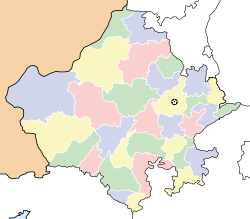
- Narlai
-
Narlai — village — Coordinates 25°19′00″N 73°32′00″E / 25.3167°N 73.5333°ECoordinates: 25°19′00″N 73°32′00″E / 25.3167°N 73.5333°E Country India State Rajasthan District(s) Pali Subdistrict(s) Desuri Parliamentary constituency Pali (Lok Sabha Constituency) Assembly constituency Bali Civic agency Gram Panchayat Population 6,190 (2001[update]) Sex ratio 1085 ♂/♀ Official languages Hindi, Marwari Time zone IST (UTC+05:30) Area
• 356 metres (1,168 ft)
Climate
Temperature
• Summer
• Winter
• 30 °C (86 °F)
• 44 °C (111 °F)
• 05 °C (41 °F)Narlai is a village in Desuri tehsil of Pali district in Rajasthan state in India.
It lies 36 km to Ranakpur and is at base of a hillock crowned by a colossal statue of an elephant. There are several Hindu and Jain temples. The temples of Adinath and Lord Shiva are most prominent temples. The ceilings of these temple are decorated with fine murals.
Demographics
According to Census 2001, Narlai has a population of 6,190, where male are 2,968 and female are 3,222.[1]
References
External links
Pali Bali · Falna · Jaitaran · Marwar Junction · Pali · Rani · Nimaj · Sadri · Sojat · Sojat Road · Sumerpur · Takhatgarh
Cities and towns
in other districtsAjmer · Alwar · Banswara · Baran · Barmer · Bharatpur · Bhilwara · Bikaner · Bundi · Chittorgarh · Churu · Dausa · Dholpur · Dungarpur · Hanumangarh · Jaipur · Jaisalmer · Jalore · Jhalawar · Jhunjhunu · Jodhpur · Karauli · Kota · Nagaur · Pratapgarh · Rajsamand · Sawai Madhopur · Sikar · Sirohi · Sri Ganganagar · Tonk · Udaipur
Categories:- Villages in Pali district
- Pali district
- Rajasthan geography stubs
Wikimedia Foundation. 2010.


