- Mount Hay (New South Wales)
-
Mount Hay 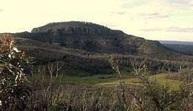
Mount HayLocation New South Wales, Australia
 Mount Hay
Coordinates 33°37′16″S 150°24′40″E / 33.621°S 150.411°ECoordinates: 33°37′16″S 150°24′40″E / 33.621°S 150.411°E Mount Hay is a mountain in the Blue Mountains National Park, New South Wales, Australia. It is located approximately one hundred kilometres west of Sydney and fifteen kilometres north-west of the nearest town, Leura.
Description
Mount Hay has a dome-like shape at the summit and it can be found on the southern escarpment of the Grose Valley, one of the main valleys of the Blue Mountains. There is a walking track that goes to the top of the mountain, but the initial approach is via the Mount Hay Road, which branches off from the Great Western Highway at the town of Leura. The road, which is unsealed and fairly rough, winds generally north-east for fourteen kilometres or so and terminates at the Mount Hay picnic area. The latter is extremely basic, with an unreliable water tank, a stone fireplace and enough room for one tent at a pinch.[1]
From the picnic area, a track goes to the mountain, which is just over a kilometre away. There are good views of the Grose Valley as the track approaches the mountain, but the views disappear as the track gets higher up. At the top, there is a trigonometric station (generally known as a trig), but there are no views because of the timber. The top of the mountain is 944 metres above sea level.[2]
Activities
The area is popular for bushwalking but not as overused as some parts of the Grose Valley, because it is some distance from the nearest residential areas. About four kilometres south of the picnic area there are other walk possibilities, in the form of the Lockley Track, which goes down to the Blue Gum Forest, in the Grose Valley. There is also a short walk to the top of the plateau known as Flat Top. Just a little north of the picnic area, there is another track that goes west to Butterbox Point, which provides dramatic views of the valley. The area is also popular for photography because of the extensive valley views. There are no authorised camp sites, but camping is allowed at a reasonable distance from any road. From the summit, Sydney City is barely visible in the far distance.
References
Blue Mountains topics Towns, suburbs
& localitiesBell • Berambing • Bilpin • Blaxland • Blackheath • Bullaburra • Faulconbridge • Glenbrook • Hartley Vale • Hazelbrook • Katoomba • Kings Tableland • Lapstone • Lawson • Leura • Linden • Little Hartley • Medlow Bath • Megalong • Mount Irvine • Mount Riverview • Mount Tomah • Mount Victoria • Mount Wilson • North Katoomba • Shipley • Springwood • Sun Valley • Valley Heights • Warrimoo • Wentworth Falls • Winmalee • Woodford • Yellow Rock • Yosemite
Mountain peaks Mount Banks · Mount Bindo · Mount Boyce · Mount Hay · Mount Irvine · Mount Piddington · Mount Solitary · Mount Trickett · Mount Wilson · Mount York · Narrow Neck PlateauTourist attractions Valleys Waterfalls Wentworth FallsHistory National Parks Miscellaneous Categories:- Mountains of New South Wales


Wikimedia Foundation. 2010.