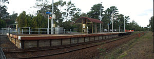
- Morradoo railway station
-
Morradoo 

Station information Code MRO Distance from
Flinders Street71 km Operator Metro Trains Melbourne Lines Stony Point # Platforms 1 # Tracks 1 Status Unmanned station Metlink profile Link Melway map Link Google map Link Metcard / Myki Zone 2 Morradoo is a railway station in Melbourne, Victoria, Australia, located in the suburb of Crib Point, on the Stony Point railway line. Morradoo station is unmanned and is in Metcard Zone 2.
Contents
Facilities
Morradoo is located at the southern end of the Disney Street level crossing, which also provides station access. It was formerly known as "Stopping Place No. 15".
The station consists of one side platform, with a small steel shelter at the Frankston end of the station. Like all stations on the Stony Point line, the station contains no Metcard machine or validators, with passengers requiring to pre-purchase tickets and validate them on arrival at Frankston.[1]
Platforms and services
Platform 1:
- Stony Point line—all stations services to Frankston, for connecting Frankston line services to Flinders Street
- Stony Point line—all stations services to Stony Point
Bus services
- 782 Frankston – Flinders via Hastings (every day). Operated by Peninsula Bus Lines.
History
Morradoo station opened on 7 November 1960 as Rail Motor Stopping Place Number 15 (abbreviated to RMSP 15),[2] and was renamed Morradoo in 1996 by Bree Saunders of Crib Point Primary School, who won a local competition to rename the station. Her suggestion, Morradoo was accepted and the new name was installed in January 1997.
In 1996 the platform was extended to 25 m and a new shelter was erected.
The name "Morradoo" comes from an Aboriginal name meaning "powder and shot". It was also the original name for Crib Point.
References
Station Navigation Stony Point line ← Previous Station Bittern | Crib Point Next Station → Entire network Melbourne's public transport - Metlink Modes and network Ticketing Metropolitan rail operators Metro Trains Melbourne (heavy rail) • KDR Melbourne - Yarra Trams (tram/light rail)Regional rail operators V/Line (heavy rail)Metropolitan and regional bus operators Broadmeadows Bus Service • Cardinia Transit • Cranbourne Transit • Driver Bus Lines • Dyson's Bus Services • Eastrans • East West Bus Company • Grenda's • Hope Street Bus Line • Invicta Bus Services • Ivanhoe Bus Company • Kastoria Bus Lines • Martyrs Bus Service • Melbourne Bus Link • McKenzie's • Moonee Valley • Moorabbin Transit • Moreland Buslines • NationalBus • Panorama Coaches • Peninsula Bus Lines • Portsea • Reservoir • Ryan Brothers Bus Service • Sita Buslines • Skybus Super Shuttle • Sunbury Bus Service • Tullamarine Bus Lines • US Bus Lines • Ventura Bus Lines • WestransPlanned infrastructure Melbourne Metro • Regional Rail Link • Proposed Rail ExtensionsAuthorities Coordinates: 38°21′14″S 145°11′21″E / 38.3538°S 145.1893°E
Categories:- Railway stations in Melbourne
- Railway stations opened in 1960
- Melbourne rail transport stubs
Wikimedia Foundation. 2010.
