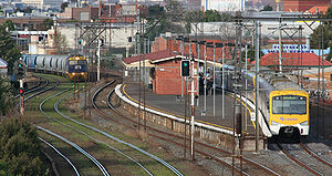
- Middle Footscray railway station
-
Middle Footscray 

Station information Code MFY Distance from
Flinders Street7.8 km Operator Metro Trains Melbourne Lines Sydenham # Platforms 2 # Tracks 2 Status Unmanned Station Metlink profile Link Melway map Link Metcard / Myki Zone 1 Middle Footscray is a railway station in Melbourne, Victoria, Australia located in the suburb of Footscray, on the Sydenham railway line. Middle Footscray is unmanned and is in Metcard Zone 1.
Contents
Facilities
The station is located at the western end of the Victoria Street road underpass, and is accessible from an underpass from the same road.
The station consists of two platforms, in an island format, with a large brick building at the Flinders Street end of the station. Due to being one of the most isolated stations on the network, a small coin-only Metcard ticket machine is located at the entrance to the island platform, which dispenses only selected ticketing options.
Two dual gauge tracks run beside the station forming the South Kensington - West Footscray goods lines, linking the Port of Melbourne and other freight terminals to the rest of the state. The tracks also form part of the Melbourne to Sydney standard gauge line.
Platforms, services and connecting bus services
Platform 1:
- Suburban Metro Trains services to Flinders Street
Platform 2:
- Suburban Metro Trains services to Watergardens
Bus Services
- 223 Highpoint Shopping Centre. Operated by Melbourne Bus Link
- 223 Yarraville. Operated by Melbourne Bus Link
History
Middle Footscray Station opened on 10 December 1906.[1]
References
Station Navigation Sydenham line ← Previous Station Footscray | West Footscray Next Station → Entire network Melbourne's public transport - Metlink Modes and network Ticketing Metropolitan rail operators Regional rail operators Metropolitan and regional bus operators Broadmeadows Bus Service • Cardinia Transit • Cranbourne Transit • Driver Bus Lines • Dyson's Bus Services • Eastrans • East West Bus Company • Grenda's • Hope Street Bus Line • Invicta Bus Services • Ivanhoe Bus Company • Kastoria Bus Lines • Martyrs Bus Service • Melbourne Bus Link • McKenzie's • Moonee Valley • Moorabbin Transit • Moreland Buslines • NationalBus • Panorama Coaches • Peninsula Bus Lines • Portsea • Reservoir • Ryan Brothers Bus Service • Sita Buslines • Skybus Super Shuttle • Sunbury Bus Service • Tullamarine Bus Lines • US Bus Lines • Ventura Bus Lines • WestransPlanned infrastructure Authorities Coordinates: 37°48′09″S 144°53′29″E / 37.8025°S 144.8915°E
Categories:- Railway stations in Melbourne
- Railway stations opened in 1906
- Melbourne rail transport stubs
Wikimedia Foundation. 2010.
