- Badarpur, Delhi
-
Badarpur — town — Coordinates 28°31′00″N 77°20′00″E / 28.5167°N 77.3333°ECoordinates: 28°31′00″N 77°20′00″E / 28.5167°N 77.3333°E Country India State Delhi District(s) South Delhi Parliamentary constituency South Delhi Assembly constituency Badarpur Civic agency Municipal Corporation of Delhi Time zone IST (UTC+05:30) Area
• 191 metres (627 ft)
Codes-
• Pincode • 110044
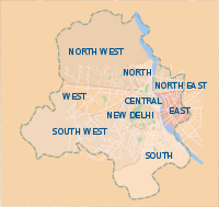
FootnotesBadarpur (Hindi: बदरपुर) is a historic town in South Delhi district in Delhi, at a distance of 17 km in south east. Situated close to its edge with Haryana state, Faridabad district, the area is commonly known as "Badarpur Border". Situated on Mathura Road joining Delhi with Agra-Mathura, on NH 2 (Delhi-Howrah) Highway, a part of the historic Grand Trunk Road that once joined Bengal to Kabul. It is the starting point for the on the "Mehrauli- Badarpur Road" that passed through Tughlaqabad, Khanpur, Delhi, Saket towards Mehrauli. The Delhi Faridabad Skyway elevated highway also opened at the starting of MB Road. It is serviced by Badarpur station of Delhi Metro on Violet Line which terminates here.[1]
Badarpur is also home to the the Badarpur Thermal power plant (BTPS) of National Thermal Power Corporation (NTPC), opened in 1973 and an important power source to South Delhi and East Delhi district.
Contents
Overview
It once housed one of sarais (caravan resthouses), known as Sarai Badarpur, along the historic Grand Trunk Road, probably building during the period of Jahangir in 16th century, prior to that Ghiyas-ud-din Tughlaq built the Qutub-Badar Road as he established the fifth historic city of Delhi, Tughlaqabad, in 13th century AD, which connected the city to the Grand Trunk Road.[2] The road is now known as Mehrauli-Badarpur Road.
Its surrounding areas as Jaitpur, Molar Band and Molarband Extension, Mithe Pur (Mithapur), Asola, Surajkund and Tughlaqabad. Further east, Badarpur Khadar, a village situated in the river bed of Yamuna, it has a population of around 1000 and 550 voters.[3]
Education
The National Power Training Institute (NPTI) for North India Region under Ministry of Power, Government of India was established at Badarpur in 1974, within the Badarpur Thermal power plant (BTPS) complex.[4] 'Kendriya Vidyalaya NTPC' is also situated with NTPC campus. [5]
Administration
It is part of the Kalkaji sub-district (sub-division) of South Delhi district.[6]
Politics
It is a constituency of the Legislative Assembly of Delhi, part of the South Delhi Lok Sabha, prior to it Badarpur was part of the Outer Delhi constituency (1993-2008).[7]. After the Delhi state assembly elections, 2008, the present MLA from Badarpur is Ram Singh Netaji of Bahujan Samaj Party (BSP). [8]
Transport
Bardarpur is situated on National Highway No. 2 (Mathura Road). Delhi Transport Corporation (DTC) and private buses ply to Badarpur Border from Old Delhi Railway Station and New Delhi Railway Station.
DTC and Haryana Roadways buses going to Faridabad and Ballabgarh from Inter state Bus Terminal (ISBT) stop at BTPS Complex. DTC and Private Buses of Route No. 405, 415, 460, 473 & 479 ply to Badarpur, Buses are also available form Faridabad. The Badarpur elevated station of Delhi Metro opened on January 14, 2011, along with two preceeding elevated stations, Mohan Estate, and Tughlakabad, which extended the line beyond Sarita Vihar. and presently the Violet Line terminates here, expected to extended till Faridabad in future. [1][9]
The Delhi Faridabad Skyway a 4.4 km elevated highway started construction after 2008, and was opened in late 2010 and passed over five important traffic junctions including NTPC, Mehrauli-Badarpur Road, Jaitpur, Sarai Bypass and Sector 37 Faridabad. Situated at the road junction of Mehrauli- Badarpur Road, which has gotten increasing congested over the years, as it lies of highway NH 2 which carries major traffic to important cities of North India.[10][11]
References
- ^ a b "Sarita Vihar-Badarpur Metro from tomorrow". The Times of India. 2011-01-13. http://timesofindia.indiatimes.com/city/delhi/Sarita-Vihar-Badarpur-Metro-from-tomorrow/articleshow/7277745.cms. Retrieved 2011-10-12.
- ^ Y. D. Sharma (1974). "33. Badarpur". Delhi and its Neighbourhood. Director General, Archaeological Survey of India. p. 105.
- ^ "Facing political negligence, Badarpur Khadar awaits development". Jagran. 09 May 2011. http://post.jagran.com/facing-political-negligence-badarpur-khadar-awaits-development-1304855864.
- ^ "Our Institutes". National Power Training Institute website. http://www.npti.in/our-institues.html.
- ^ Kendrya Vidyalaya NTPC Badarpur]
- ^ "Kalkaji sub-division". South Delhi district website. http://dcsouth.delhigovt.nic.in/organization.htm.
- ^ "List of Parliamentary & Assembly Constituencies, General Election to the Lok Sabha, 2004". Government of Delhi website. http://www.delhi.gov.in/DoIT/DoIT_CEO/parliamentary.pdf.
- ^ Official Member's list, Legislative Assembly of Delhi Legislative Assembly of Delhi
- ^ "DMRC opens Sarita Vihar-Badarpur section". The Hindu. January 14, 2011. http://www.thehindu.com/news/cities/Delhi/article1092318.ece.
- ^ "HCC bags Rs.340 crore BOT project of NHAI for Badarpur elevated highway". Financial Express. Jul 01, 2008. http://www.financialexpress.com/news/hcc-bags-rs.340-crore-bot-project-of-nhai-for-badarpur-elevated-highway/329877/0.
- ^ "Badarpur flyover to open today". The Times of India. Oct 5, 2010. http://articles.timesofindia.indiatimes.com/2010-10-05/delhi/28253226_1_badarpur-flyover-second-carriageway-hcc.
External links
Categories:- Neighbourhoods of Delhi
- South Delhi district
-

Wikimedia Foundation. 2010.