- McNeel Mill
-
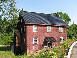
McNeel MillMcNeel Mill, July 2008
Location: US 219, Mill Point, West Virginia Coordinates: 38°9′26″N 80°10′55″W / 38.15722°N 80.18194°WCoordinates: 38°9′26″N 80°10′55″W / 38.15722°N 80.18194°W Area: 1.5 acres (0.61 ha) Architect: McNeel,Isaac Governing body: Private NRHP Reference#: 85001783[1] Added to NRHP: August 8, 1985 The McNeel Mill is located just south of the intersection of route 219 and route 39 and route 55 in Mill Point, Pocahontas County, West Virginia (2 miles north of Hillsboro, West Virginia). The mill was completed in 1868 by Isaac McNeel and was in operation until 1947. The three-story wood-frame mill operated with a 21-foot (6.4 m) diameter metal mill wheel.[2]
The present mill is the most recent of a series of mills that have stood on the site since 1778.[2]
Recently the Pocahontas County Historical Society, The Pocahontas County Historic Landmarks Commission, West Virginia Division of Culture and History, The West Virginia State Historic Preservation Office, The Snowshoe Foundation and private individuals have made donations in order to preserve this great building and return it to working order for demonstration purposes.
The property was listed on the National Register of Historic Places on August 8, 1985.[1]
References
- ^ a b "National Register Information System". National Register of Historic Places. National Park Service. 2009-03-13. http://nrhp.focus.nps.gov/natreg/docs/All_Data.html.
- ^ a b Sharp, Jane Price; McNeel, Landy F. (June 7, 1985). "National Register of Historic Places Inventory - Nomination Form: McNeel Mill". National Park Service. http://www.wvculture.org/shpo/nr/pdf/pocahontas/85001783.pdf. Retrieved 22 February 2011.
U.S. National Register of Historic Places in West Virginia Lists by county Barbour • Berkeley • Boone • Braxton • Brooke • Cabell • Calhoun • Clay • Doddridge • Fayette • Gilmer • Grant • Greenbrier • Hampshire • Hancock • Hardy • Harrison • Jackson • Jefferson • Kanawha • Lewis • Lincoln • Logan • Marion • Marshall • Mason • McDowell • Mercer • Mineral • Mingo • Monongalia • Monroe • Morgan • Nicholas • Ohio • Pendleton • Pleasants • Pocahontas • Preston • Putnam • Raleigh • Randolph • Ritchie • Roane • Summers • Taylor • Tucker • Tyler • Upshur • Wayne • Webster • Wetzel • Wirt • Wood • Wyoming

Other lists Categories:- Industrial buildings and structures on the National Register of Historic Places in West Virginia
- Buildings and structures in Pocahontas County, West Virginia
- Grinding mills in the United States
- West Virginia Registered Historic Place stubs
Wikimedia Foundation. 2010.


