- Mount Matutum
-
Matutum 
MatutumElevation 2,286 m (7,500 ft) Prominence 1,950 m (6,398 ft) [1] Listing List of Ultras in the Philippines Location Location of Matutum in the Philippines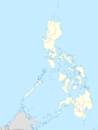
 Matutum
Location  South Cotabato, Philippines
Range Hamiguitan Mountain Range Coordinates 6°26′00″N 125°06′30″E / 6.4333333°N 125.10833°ECoordinates: 6°26′00″N 125°06′30″E / 6.4333333°N 125.10833°E[1][2][3] Geology Type Stratovolcano Volcanic arc/belt Cotabato Arc Last eruption 1911 Matutum is an active volcano in the Philippines.[4][5]
Contents
Location
Matutum is located in the province of South Cotabato, on the island of Mindanao, in the south of the Philippines, at geographical coordinates 6°22'N, 125°06.5'E.[2]
It is 15 km north of Polomolok, and about 30 km north-northwest of General Santos City
Physical features
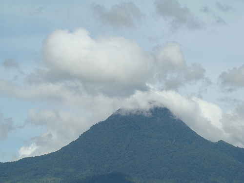
Matutum is a stratovolcano that rises 2,286 meters asl with a base diameter of 25 km.[5]
It has 2 hot springs, called Akjmoan and Linan, 5.7 km west-southwest of the volcano.
Adjacent volcanic edifices are Landayao, Tampad, and Albulhek, which are all west of the volcano, and Magolo to the north.
There is a well-preserved 320 metre wide crater at the volcano's summit. The crater is breached by three gorges and has a 120 metre deep, densely forested floor.[2]
Eruptions
Volcanologists suspect that Matutum may have had a phreatic explosion on March 7, 1911.[5]
Matutum is one of the active volcanos in the Philippines. All are part of the Pacific ring of fire.
See also
- Active volcanos in the Philippines
- Potentially active volcanos in the Philippines
- Inactive volcanos in the Philippines
- Philippine Institute of Volcanology and Seismology
- Mindanao
- Volcano
References
- ^ a b de Ferranti, Jonathan; Aaron Maizlish. "Philippine Mountains - 29 Mountain Summits with Prominence of 1,500 meters or greater". http://www.peaklist.org/WWlists/ultras/philippines.html. Retrieved 2009-01-09.
- ^ a b c "Mount Matutum Profile Global Volcanism Program". National Museum of Natural History (Smithsonian). http://www.volcano.si.edu/world/volcano.cfm?vnum=0701-02=. Retrieved 2008-10-28.
- ^ "Philippine Institute of Volcanology and Seismology (PHIVOLCS) Matutum Volcano Page". Department of Science & Technology (Philippines). http://volcano.phivolcs.dost.gov.ph/update_VMEPD/Volcano/VolcanoList/matutum.htm. Retrieved 2009-06-19.
- ^ "List of Active Volcanoes in the Philippines (PHIVOLCS)". Philippine Institute of Volcanology and Seismology. http://www.phivolcs.dost.gov.ph/index.php?option=com_content&task=view&id=57&Itemid=114. Retrieved 2009-01-28.
- ^ a b c "Mount Matutum Profile on PHIVOLCS". =Philippine Institute of Volcanology and Seismology. http://volcano.phivolcs.dost.gov.ph/update_VMEPD/Volcano/VolcanoList/matutum.htm. Retrieved 2009-01-28.
World Heritage Sites in the Philippines World Heritage Sites Baroque Churches of the Philippines (San Agustin Church · Paoay Church · Santa Maria Church · Miag-ao Church) · Puerto Princesa Subterranean River National Park · Rice Terraces of the Philippine Cordilleras ( Batad Rice Terraces · Bangaan Rice Terraces · Hungduan Rice Terraces · Mayoyao Central Rice Terraces · Nagacadan Rice Terraces) · Tubbataha Reef · Historic Town of Vigan
Tentative List Agusan Marsh Wildlife Sanctuary · Angono Triglyphs · Apo Reef Natural Park · Baroque Churches of the Philippines Extension (Boljoon Church · Guiuan Church · Loboc Church · Lazi Church · Tumauini Church) · Batanes Protected Landscapes and Seascapes · Butuan Archeological Sites · Chocolate Hills Natural Monument · Coron Island Natural Biotic Area · El Nido-Taytay Managed Resource Protected Area · Jesuit Churches of the Philippines (Guiuan Church · Baclayon Church · Loboc Church ) · Kabayan Mummy Burial Caves · Ligwasan Marsh · Mount Apo Natural Park · Mount Hamiguitan Range Wildlife Sanctuary · Mount Iglit-Baco National Park · Mount Malindang Range Natural Park · Mount Matutum Protected Landscape · Mount Pulag National Park · Neolithic Shell Midden Sites in Lal-lo and Gattaran Municipalities · Northern Sierra Madre Natural Park and outlying areas inclusive of the buffer zone · Paleolithic Archaeological Sites in Cagayan Valley · Panglao Island, Bohol · Petroglyphs and Petrographs of the Philippines · San Sebastian Church · Spanish Colonial Fortifications of the Philippines (Fuerza de Capul · Dauis Watchtower · Punta Cruz Fortification · Fuerza de San Andres · Fuerza de Sta. Isabel) · Taal Volcano Protected Landscape, Batangas · The Maranao Settlement of Tugaya · The Tabon Cave Complex and all of Lipuun · Turtle Islands Wildlife SanctuaryPrevious Nomination External links
Categories:- Stratovolcanoes
- Subduction volcanoes
- Volcanoes of Mindanao
- Mountains of the Philippines
- South Cotabato
- Active volcanoes of the Philippines

Wikimedia Foundation. 2010.