- Chocolate Hills
-
Chocolate Hills Natural Monument * UNESCO World Heritage Site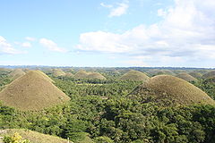
Country Philippines Type Natural Region ** Asia-Pacific * Name as inscribed on World Heritage List
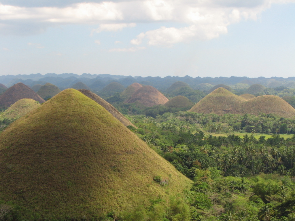
** Region as classified by UNESCOThe Chocolate Hills is an unusual geological formation in Bohol province, Philippines.[1] According to the latest accurate survey done,[citation needed] there are 1,776 hills spread over an area of more than 50 square kilometres (20 sq mi). They are covered in green grass that turns brown during the dry season, hence the name.
The Chocolate Hills is a famous tourist attraction of Bohol. They are featured in the provincial flag and seal to symbolize the abundance of natural attractions in the province.[2] They are in the Philippine Tourism Authority's list of tourist destinations in the Philippines;[3] they have been declared the country's third National Geological Monument and proposed for inclusion in the UNESCO World Heritage List.[3]
Contents
Description
 The Chocolate Hills
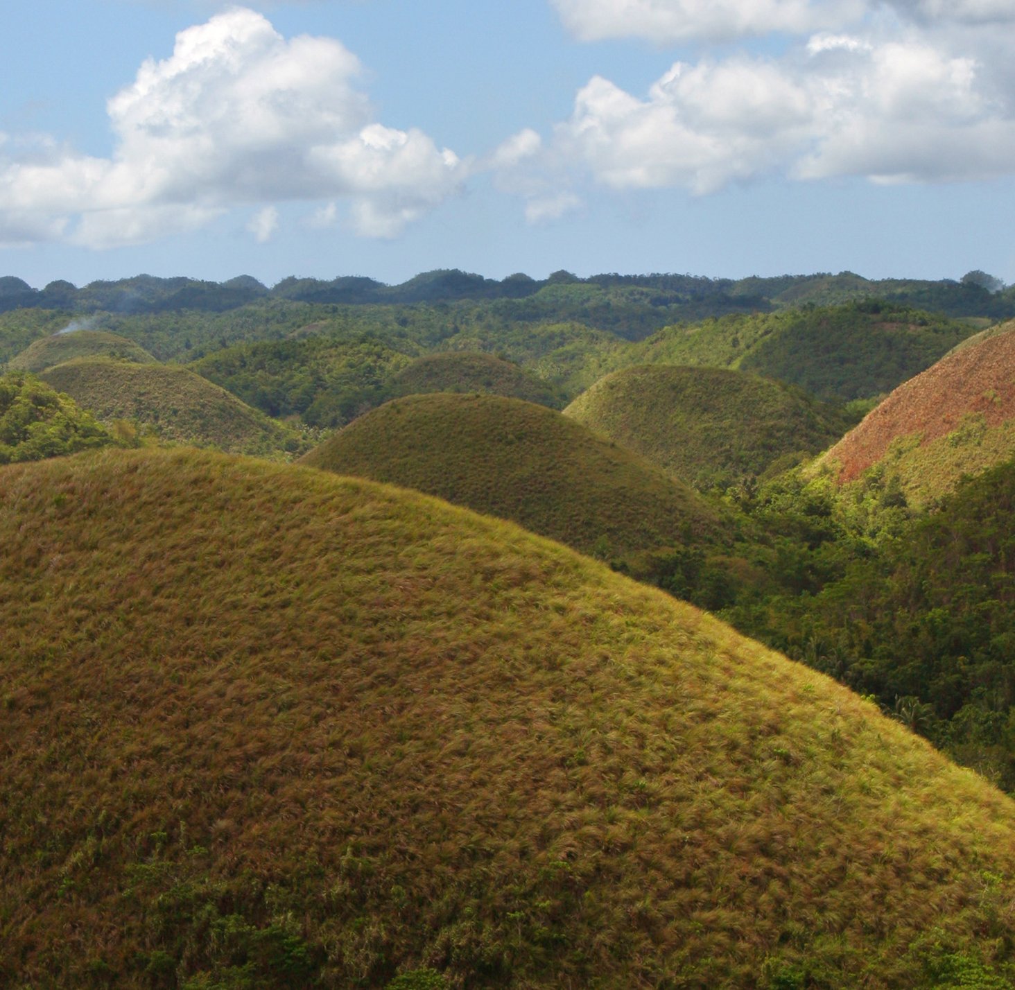
The Chocolate Hills form a rolling terrain of haycock hills – mounds of a generally conical and almost symmetrical shape.[4] Estimated to be from 1,268 to about 1,776 individual mounds, these cone-shaped or dome-shaped hills are actually made of grass-covered limestone. The domes vary in sizes from 30 to 50 metres (98 to 160 ft) high with the largest being 120 metres (390 ft) in height. Bohol's "main attraction", these unique mound-shaped hills are scattered by the hundreds throughout the towns of Carmen, Batuan and Sagbayan in Bohol.[5]
During the dry season, the grass-covered hills dry up and turn chocolate brown. This transforms the area into seemingly endless rows of "chocolate kisses". The branded confection is the inspiration behind the name, Chocolate Hills.[3]
Vegetation
 The Chocolate Hills Natural Geological Monument
The vegetation of the Chocolate Hills is dominated by hard grass species such as Imperata cylindrica and Saccharum spontaneum. Several Compositae and ferns also grow on them. In between the hills, the flat lands are cultivated with rice and other cash crops. However, the natural vegetation on the Chocolate Hills is now threatened by quarrying activities.[6]
Origin
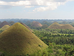 The Chocolate Hills in Carmen, Bohol
The Chocolate Hills are conical karst hills similar to those seen in the limestone regions of Slovenia, Croatia, northern Puerto Rico, and Pinar del Río Province, Cuba. These hills consist of Late Pliocene to Early Pleistocene, thin to medium bedded, sandy to rubbly marine limestones. These limestones contain the aboundant fossils of shallow marine foraminifera, coral, mollusks, and algae.[7][8] These conical karst hills, called mogote, are created by a combination of the dissolution of limestones by rainfall, surface water, and groundwater and their subaerial erosion by rivers and streams after they had been uplifted above sea level and fractured by tectonic processes. These hills are separated by well developed flat plains and contain numerous caves and springs. The Chocolate Hills are considered to be a remarkable example of conical karst topography.[9][10][11]
The origin for the conical karst of the Chocolate Hills is described in popular terms on the bronze plaque at the viewing deck in Carmen, Bohol. This plaque states that they are eroded formations of a type of marine limestone that sits on top of hardened clay.[12][13] The plaque reads:
The unique land form known as the Chocolate Hills of Bohol was formed ages ago by the uplift of coral deposits and the action of rain water and erosion.[12] The plaque also makes reference to a fanciful explanation of the origin of the Chocolate Hills that is unsupported by any published scientific research, i.e. either Hillmer[7] or Travaglia and others,[8] when it states:
the grassy hills were once coral reefs that erupted from the sea in a massive geologic shift. Wind and water put on the finishing touches over hundreds of thousands of years.[12] Self-published, popular web pages present a variety of fanciful and less credible explanations about how these hills formed. They include sub-oceanic volcanism; limestone covered blocks created by the destruction of an active volcano in a cataclysmic eruption;[14] coral reefs that were raised from the sea as the result of a massive geologic shift; and tidal movements.[15] The lack of any exposed or associated volcanic rocks anywhere in the Chocolate Hills refutes the popular theories involving volcanic eruptions. These theories involving either a sudden, massive geologic shift, coral reefs being erupted from the sea, or tidal movements lack any collaborating evidence and support among geologists.[7][8]
Legend
Four legends explain the formation of the Chocolate Hills. The first tells the story of two feuding giants who hurled rocks, boulders, and sand at each other. The fighting lasted for days, and exhausted the two giants. In their exhaustion, they forgot about their feud and became friends, but when they left they forgot to clean up the mess they had made during their battle, hence the Chocolate Hills.[12][16]
A more romantic legend tells of a giant named Arogo who was extremely powerful and youthful. Arogo fell in love with Aloya, who was a simple mortal. Aloya's death caused Arogo much pain and misery, and in his sorrow he could not stop crying. When his tears dried, the Chocolate Hills were formed.[17]
The third legend tells of a town being plagued by a giant carabao, who ate all of their crops. Finally having had enough, the townsfolk took all of their spoiled food and placed it in such a way that the carabao would not miss it. Sure enough, the carabao ate it, but his stomach couldn't handle the spoiled food, so he defecated, leaving behind him a mound of feces, until he had emptied his stomach of the food. The feces then dried, forming the Chocolate Hills.
The last legend is about a gluttonous giant named Miguel that eats everything in his path. One day he came to a plain. He saw a beautiful young woman named Adrianna. To win her affection, he needed to lose weight. So he excreted everything he ate. In the end, his fecal matter covered the land and he won Eng's affection.
Tourism development
The Chocolate Hills placed Bohol on the tourist map long before the beautiful white beaches of the island became major tourist destinations.[16] The most famous and signature tourist attraction of Bohol, it is a prime tourist destination in the Philippines.[18] This is because the Chocolate Hills are incomparable and is one of the country's most spectacular sceneries. Philippine President Gloria Macapagal-Arroyo, who admits that she is the No. 1 tourist of Bohol for having visited the province so many times, said: "Bohol is a major tourist province. The fame of the Chocolate Hills is not only known in the country but worldwide."[15] The national government has chosen the Chocolate Hills as one of its "flagship tourist destinations".
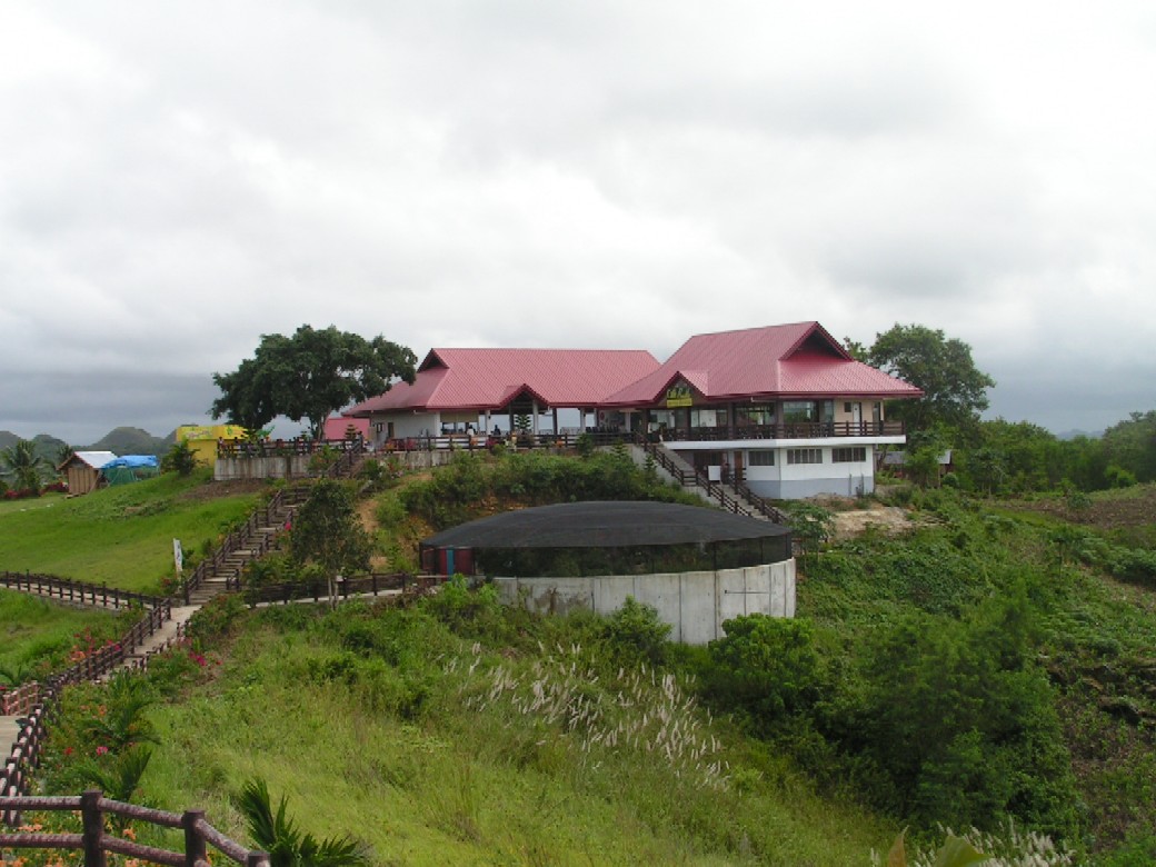
Of the 1,247 hills, two have been developed into resorts for tourism.[19] The original resort is located in Carmen, Bohol located in Barangay Buenos Aires, only a few minutes drive from downtown Carmen. The resort in Carmen is called Chocolate Hills Complex. The more recent one in Sagbayan is called Sagbayan Peak.[20]
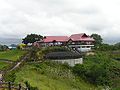
The original viewing station of the Chocolate Hills is a government-owned and operated resort called "Chocolate Hills Complex" located in Carmen, Bohol, about 55 kilometres (34 mi) from Tagbilaran City[21] and about 5 kilometres (3.1 mi) from the town proper of Carmen, Bohol.
The Chocolate Hills Complex has a restaurant, hostel with swimming pool and an observation deck where one could view and even count the hills at the view deck 210 feet (64 m) above the ground. There are a total of 214 steps leading to the observation or view deck. Here one can view the landscape that is covered with more than a thousand Chocolate Hills.[22] The Chocolate Hills Complex is composed of two hills developed into a resort. An observation deck on the higher hill offers a 360-degree panorama of the surrounding area.
The other way to view the Chocolate Hills is at "Sagbayan Peak", a mountain resort in Sagbayan town, about 75 kilometres (47 mi) northwest of Tagbilaran City. Viewing is made from the deck of an elevated ridge that provides an unobstructed view of the Chocolate Hills as well as the sea off Cebu City. This is only 18 kilometres (11 mi) from the Chocolate Hills complex in neighboring Carmen town.[20]
Sagbayan Peak is a 5-hectare (12-acre) mountaintop resort and recreation center. Its viewing deck offers a 360-degree perspective of the Chocolate Hills plus the blue sea that separates Bohol and Cebu.[23] The peak now has a restaurant and a children's park with Bugs Bunny, Snow White and the Seven Dwarfs, and various other Toontown figures.[24] Aside from the function hall and viewing deck, a hotel, swimming pool, driving range, a butterfly dome and a tarsier sanctuary are planned. A 100-hectare (250-acre) golf course is also planned.[24]
Patria Aurora Roa, tourism director for Central Visayas, was happy to see the latest addition to Bohol's tourist attractions. This was echoed by Bohol Governor Erico Aumentado, who said: "The Sagbayan Peak is a welcome note for Bohol tourism."[20]
Protection
Legislation
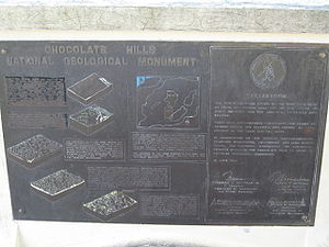 Bronze Plaque at Chocolate Hills Complex View Deck
The National Committee on Geological Sciences declared the Chocolate Hills of Bohol a National Geological Monument on June 18, 1988, in recognition of its special characteristics, scientific importance, uniqueness, and high scenic value. As such, this included the Chocolate Hills among the country's protected areas. More protection was provided by Proclamation No. 1037 signed by then President Fidel V. Ramos upon the recommendation of the DENR on July 1, 1997 which establish the Chocolate Hills and the areas within, around, and surrounding them located in the Municipalities of Carmen, Batuan and Sagbayan, Bilar, Valencia and Sierra Bullones, Province of Bohol as a natural monument to protect and maintain its natural beauty and to provide restraining mechanisms for inappropriate exploitation. As such, they are covered under the National Integrated Protected Areas System (NIPAS) with the Department of Environment and Natural Resources (DENR) as the lead implementing agency for its protection.[25]
Land use conflict prompted Philippine President Gloria Macapagal-Arroyo to sign an amendment to Proclamation 468 dated September 26, 1994 declaring the land around or in between Chocolate Hills as no longer part of the national monument during the Bohol Sandugo Celebration on July 17, 2002. This amendment allowed the tracts of land surrounding and within the famous tourist spot to be developed by the provincial government and other entities that have control over the area. Further, the amended proclamation ensures that the areas that have to be preserved are preserved, while those that could be developed would be excluded from the national monument area and classified as alienable and disposable by the government. The President initially decided on the issue during the joint meeting of the Regional Development Council-Regional Peace and Order Council (RDC-RPOC) of Region VII which was conducted at the Bohol Tropics Resort.[26]
On July 6, 2004, the Philippine House of Representatives introduced House Bill No. 01147 entitled "an act declaring the Chocolate Hills as national patrimony and geological monuments, penalizing their plunder, destruction or defacement, and for other purposes." The house bill is authored by Congressman Eladio "Boy" Jala and co-authored by Congressman Roilo Z. Golez and Edgar M. Chatto.[25]
On May 16, 2006, the Department of Environment and Natural Resources (DENR) submitted the Chocolate Hills to the UNESCO World Heritage for inclusion in the list of Natural Monuments because of its outstanding universal value, falling under criteria vii – superlative natural phenomena or areas of exceptional natural beauty and aesthetic importance. The protection, management, authenticity and integrity of properties are also important considerations.[3]
Amidst reports that quarrying has leveled off some of the mounds, Governor Erico Aumentado, the governor of Bohol, issued Administrative Order No. 3, series of 2006, which prohibits the issuance of quarry permits and favorable endorsements of mining permit applications in Carmen, Batuan and Sagbayan towns to forestall any degradation of the Chocolate Hills – no matter who applies for such.[27]
The hills are already declared geological monuments and are covered under the National Integrated Protected Areas System (NIPAS) for which the Department of Environment and Natural Resources (DENR) is the lead implementing agency. Aumentado said:
As such, he ordered the prohibition of any quarrying and mining activities in the three towns. He tasked the Bohol Environment and Management Office (BEMO) to ensure that quarry permit applications or renewal thereof and requests for favorable endorsements of mining permit applications therein shall be denied due course, and to ensure compliance and enforcement of the order.[28] He also enjoined the Mines and Geosciences Bureau (MGB) of DENR to refuse all mining permit applications or renewals in the named towns.[27]
Issues
Balancing their protection, resource utilization and tourism are the challenges faced by the Chocolate Hills. Before they were designated national geological monuments, some of the hills (about 310,455 hectares) were classified as alienable and disposable[29] or private lands such that they were titled to some locals. The declaration consequently caused some social unrest, resulting in almost simultaneous civil uprising, led by the long-established New People's Army (generally described as Maoist guerrillas) establishing a new front, known as the Chocolate Hills Command.[10] To some farmers, the proclamation is a government scheme which suppresses their right to own lands. As such, conflicts between the New People's Army group and government military forces escalated, culminating in two major engagements.[10]
Being alienable and disposable lands, the Chocolate Hills are seen as quarrying assets and source of income for small-scale miners, as well as quarry materials for the province's construction projects. The challenge is how the national and local officials can harmonize the current needs of small-scale miners, the construction sector, the tourism sector, with the preservation of the Chocolate Hills.[30]
Even with their protected status, mining permits continue to be granted by DENR and local government units or LGUs.[27] Hence, mining and quarrying are still taking place. Because of this, the provincial government of Bohol has requested for the transfer of jurisdiction over the Chocolate Hills from the DENR to the provincial government of Bohol.[10]
Meanwhile, the provincial government has itself suggested that the legislation defining the Natural Monument should be changed, which will require that the proclamation be redrafted and ratified by both the Philippine House and Senate. This is a cumbersome and costly process, on which no progress has been made to date.[10]
There are also mounting complaints of mismanagement and poor service at the government-owned and operated Chocolate Hills complex and restaurant.[27] Added to this is the increase in the number of tourists visiting the Chocolate Hills which has caused traffic problems and safety issues, particularly in the Chocolate Hills complex in Carmen, Bohol.[31]
Future development and investment challenges within the Chocolate Hills area include: obtaining the national government's sanction for the project; persuading landowners to sell; convincing the Protected Areas Management Board or PAMB, which has jurisdiction over the hills, not to use its veto power over any investment requiring physical facilities.[24]
Since the natural monument proclamation bans "activity of any kind which will alter, mutilate, deface or destroy the hills." A 2003 amendment regulates activity among the privately owned areas "in between hills".
Filipinos are sensitive to perceived desecrations of so-called heritage sites. In 2003, a public outcry forced a construction firm to stop quarrying at the Chocolate Hills, and was required to restore one defaced hill to its original shape.[24]
Investment challenges include speculators bidding up property prices in the area, raising the potential cost of a proposed project.[24] Persuading investors to put their money into the poorer parts of Bohol is complicated by communist guerrillas who extort money from local officials.[24] Following his refusal to pay, Mayor Torrefranca of Sagbayan, Bohol has survived two assassination attempts since 1998.[24] In the 1998 elections, his car was torched due to his failure to pay the "permit to campaign fee".[32]
Gallery
-
Sagbayan Peak
-
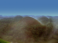
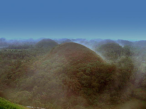
Chocolate Hills covered with fog
-
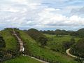
View of the Chocolate Hills from Sagbayan Peak
-
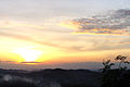
Chocolate Hills Sunset in Carmen Bohol
See also
- Breast shaped hill
Notes
- ^ Eye on the Philippines Global Eye Retrieved 22 December 2006.
- ^ The Bohol Flag and Seal www.bohol.gov.ph Retrieved 15 November 2006.
- ^ a b c d Chocolate Hills Natural Monument UNESCO World Heritage Centre Retrieved 14 November 2006.
- ^ Bohol: The Jewel Paradise of the Philippine Islands www.bohol.net Retrieved 15 November 2006.
- ^ Bohol www.dotpcvc.gov.ph Retrieved 15 November 2006.
- ^ Bohol Island Herbarium www.pnh.com.ph. Retrieved 14 November 2006.
- ^ a b c Hillmer, G., 1987, Zur geologie und morphologie der straandterrassen von Cebu und Bohol Philippinen. Berliner geographische Studien. v. 25, p. 363–376.
- ^ a b c Travaglia, C., R. Peebles, E. Bate, and A. Ferrer, 1987, Reconnaissance groundwater appraisal of Bohol Island, Philippines, by satellite data analysis. RSC Series no. 38. Food and Agriculture Organization of the United Nations, Rome, Italy.
- ^ Restificar, S. D. F., M. J. Day, and P. B. Urlich, 2006, Protection of Karst in the Philippines (Varstvo Krasa na Filipinih)., 788 KB PDF version. Acta Carsologica. v. 35, no. 2, p. 121-130.
- ^ a b c d e Urlich, P. B., M. J. Day, and F. Lynagh, 2001, Policy and practice in karst landscpe protection: Bohol, the Philippines. The Geographical Journal. v. 167, no. 4, pp. 305-323.
- ^ Leman, S. L., A, Reedman, and C. S. Pei, 2008, Geoheritage of East and Southeast Asia., 5.7 MB PDF version. The CCOP-Institute for Environment and Development, Universiti Kebangsaan, Bangi Selangor, Malaysia.
- ^ a b c d Chocolate Hills: Philippines Vacation www.philippinesvacation.org Retrieved 15 November 2006.
- ^ Bohol www.philippines.hvu.nl. Retrieved 15 November 2006.
- ^ Bohol www.tambuli.com. Retrieved 15 November 2006.
- ^ a b "Move over Boracay: Panglao Island beckons". inq7.net. Archived from the original on 2004-12-07. http://web.archive.org/web/20041217173401/http://www.inq7.net/reg/2003/nov/05/text/reg_5-1-p.htm. Retrieved 2008-10-14.
- ^ a b Bohol Chocolate Hills legend will bring a tear to your eye www.philippines-travel-guide.com. Retrieved 15 November 2006.
- ^ The Chocolate Hills www.bohol.ph. Retrieved 14 November 2006
- ^ Bohol - splendor underwater and Over Hills WOW Philippines. Retrieved 15 November 2006.
- ^ Bohol God's little Paradise library.thinkquest.org. Retrieved 22 December 2006
- ^ a b c Chito A. Fuentes. "Sagbayan Peak: A View from the Top". Philippine Daily Inquirer. Archived from the original on 2005-11-10. http://web.archive.org/web/20051110043744/http://www.inq7.net/globalnation/sec_phe/2003/aug/27-01.htm. Retrieved 2008-10-14.
- ^ Bohol Island Sightseeing Bohol Island Hotels Travel Guide. Retrieved 15 November 2006.
- ^ Bohol The Island Province www.aenet.org Retrieved 15 November 2006.
- ^ Bohol's 'Sagbayan Peak' offer a new peek at the Chocolate Hills www.newsflash.org. Retrieved 15 November 2006.
- ^ a b c d e f g Toontown comes to Bohol's Nature Monument www.newsflash.org. Retrieved 14 November 2006.
- ^ a b House Bill 001147 www.congress.gov.ph. Retrieved 14 November 2006.
- ^ GMA seeks development of parts of Chocolate Hills www.gov.ph. Retrieved 14 November 2006.
- ^ a b c d e Guv bans mining near Choco Hills The Bohol Chronicle. Retrieved 14 November 2006.
- ^ Gov issues orders to protect Choco Hills Bohol Sunday Post Retrieved 14 November 2006.
- ^ "Bohol Philippines - Splendour Underwater And Over Hills". TravelOnline Inc.. 2000. http://www.bohol.ws/bohol_philippines.htm. Retrieved 2008-10-13.[dead link]
- ^ CV gh Context of PA 21 www.neda7.net.ph. Retrieved 17 November 2006.
- ^ PNP takes action on Choco traffic www.boholchronicle.com. Retrieved 15 November 2006.
- ^ Bagaipio, Kit (2007-02-18). "Army commander warns politicians from giving to "rebel" extortionists". The Bohol Chronicle. http://www.boholchronicle.com/2007/feb/18/major1.htm. Retrieved 2008-10-14.[dead link]
External links
- UNESCO World Heritage: Chocolate Hills Natural Monument
- First Philippine National Report on the Convention on Biological Diversity, 1998
- Chocolate Hills, Bohol
Articles
- The Chocolate Hills
- "Guv bans mining near Chocolate Hills", The Bohol Chronicle, 06/11/06
- "Bohol ties w/China booms", The Bohol Chronicle, 05/14/06
- "Bohol's chocolate hills get 'sister mountain' in China", The Philippine Daily Inquirer, 10/29/06
- "Rizal town issues SOS", The Philippine Daily Inquirer, 12/11/03
- "Move over, Boracay; Panglao Island beckons", The Philippine Daily Inquirer, 11/05/03
- "Sagbayan Peak: A view from the top", Philippine Daily Inquirer, 11/11/06
- "Bohol's bounty, Philippine Daily Inquirer
- "Bohol the beautiful", Philippine Daily Inquirer
- "Guv issues orders to protect Choco Hills, aid brgy workers", Bohol Sunday Post, 06/11/06
- "Capitol wants Choco land title revoked", The Bohol Chronicle, September 17, 2006
- Bohol Chocolate Hills
- "PNP takes action on Choco traffic", The Bohol Chronicle, May 14, 2006
- House Bill 001147
- Chocolate Hills
World Heritage Sites in the Philippines World Heritage Sites Baroque Churches of the Philippines (San Agustin Church · Paoay Church · Santa Maria Church · Miag-ao Church) · Puerto Princesa Subterranean River National Park · Rice Terraces of the Philippine Cordilleras ( Batad Rice Terraces · Bangaan Rice Terraces · Hungduan Rice Terraces · Mayoyao Central Rice Terraces · Nagacadan Rice Terraces) · Tubbataha Reef · Historic Town of Vigan
Tentative List Agusan Marsh Wildlife Sanctuary · Angono Triglyphs · Apo Reef Natural Park · Baroque Churches of the Philippines Extension (Boljoon Church · Guiuan Church · Loboc Church · Lazi Church · Tumauini Church) · Batanes Protected Landscapes and Seascapes · Butuan Archeological Sites · Chocolate Hills Natural Monument · Coron Island Natural Biotic Area · El Nido-Taytay Managed Resource Protected Area · Jesuit Churches of the Philippines (Guiuan Church · Baclayon Church · Loboc Church ) · Kabayan Mummy Burial Caves · Ligwasan Marsh · Mount Apo Natural Park · Mount Hamiguitan Range Wildlife Sanctuary · Mount Iglit-Baco National Park · Mount Malindang Range Natural Park · Mount Matutum Protected Landscape · Mount Pulag National Park · Neolithic Shell Midden Sites in Lal-lo and Gattaran Municipalities · Northern Sierra Madre Natural Park and outlying areas inclusive of the buffer zone · Paleolithic Archaeological Sites in Cagayan Valley · Panglao Island, Bohol · Petroglyphs and Petrographs of the Philippines · San Sebastian Church · Spanish Colonial Fortifications of the Philippines (Fuerza de Capul · Dauis Watchtower · Punta Cruz Fortification · Fuerza de San Andres · Fuerza de Sta. Isabel) · Taal Volcano Protected Landscape, Batangas · The Maranao Settlement of Tugaya · The Tabon Cave Complex and all of Lipuun · Turtle Islands Wildlife SanctuaryPrevious Nomination Historic Centre of Manila Intramuros · Town of TaalCategories:- Bohol
- Monuments and memorials in the Philippines
- Mountain ranges of the Philippines
- National Geological Monuments in the Philippines
- Visayan landmarks
- Protected areas of the Philippines
-


Wikimedia Foundation. 2010.