- Mount Malindang
-
Mount Malindang 
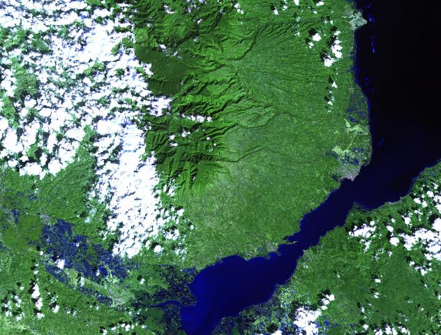
Landsat image of Mount Malindang and its vicinityElevation 2,404 m (7,887 ft) [1][2] Prominence 2,290 m (7,513 ft) [1] Location Location of Mount Malindang in the Philippines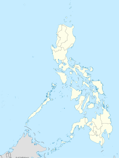
 Mount Malindang
Location  Misamis Occidental, Philippines
Range Malindang Mountain Range Coordinates 8°13′03″N 123°38′12″E / 8.2175°N 123.63667°ECoordinates: 8°13′03″N 123°38′12″E / 8.2175°N 123.63667°E[1][3] Geology Type Stratovolcano Volcanic arc/belt Sulu-Zamboanga Arc Last eruption Pleistocene to Holocene[3] Climbing First ascent Maj. E.A. Mearns, W.I. Hutchinson, and party in May 1906[4] Mount Malindang is a complex volcano located in the province of Misamis Occidental in the southern island of Mindanao, Philippines. The least studied mountain range was formed through several volcanic activities some of which could be historical, evident by the presence of two calderas, surrounded by high rock walls, cinder cones, dome volcano plugs, two sulfurous hot springs, and a crater lake named Lake Duminagat. The amphitheater structures have extensive distribution of volcanic rocks, carbonized wood that are found in pyroclastic deposits. The entire mountain range is dissected by several canyons and ravines making its terrain very rugged and the forested slopes covered with beautiful scenery.[5]
Contents
Classification
Malindang has no known historical eruptions and is classified as inactive by the Philippine Institute of Volcanology and Seismology.[6]
Mount Malindang Natural Park
Mount Malindang and the whole Malindang Mountain Range alluring qualities come from its waterfalls, crater lake and dense virgin forests which host diverse and rare species of flora and fauna. On June 19, 1971, the area was proclaimed as Mount Malindang National Park by virtue of Republic Act 6266. Under the establishment of National Integrated Protected Areas System (NIPAS) in 1992, the park was reclassified and was renamed as Mount Malindang Range Natural Park on August 2, 2002 through Proclamation No. 228.
The park is encompasses three provinces - Misamis Occidental, Zamboanga del Sur and Zamboanga del Norte - covering an area of 53,262 hectares (131,610 acres) of which about 33,000 hectares (82,000 acres) or 62% of forest remaining. About 20,000 hectares (49,000 acres) are cultivated and inhabited by indigenous people mostly the Subanon tribe.[5][7]
Fauna
The national park is known to harbor a rich and unique biodiversity that is yet to be explored. The mountain and its outlying areas, some are unexplored, are home to some of the endemic and endangered species in the Philippines, which include:.[5]
- Philippine Eagle (Pithecophaga jefferyi)
- Rufous Hornbill (Buceros hydrocorax)
- Tarsier (Tarsius philippinensis)
- Flying Lemur (Cynocephalus volans)
- Philippine Deer (Cervus mariannus)
- Long-tailed Macaque (Macaca fascicularis)
- Asian Palm Civet (Paradoxurus hermaphroditus subsp. philippinensis)
- Philippine Hawk-eagle (Nisaetus philippensis)
- Rough-armored tree frog
- Water monitor lizard (Varanus marmoratus)
- Philippine warty pig (Sus philippensis)
- Philippine hanging parakeet/Colasisi (Loriculus philippensis)
- Philippine Woodpecker (Dendrocopos maculatus)
- Greater Mindanao Shrew (Crocidura grandis)
Economic Importance
Mount Malindang and its adjoining mountain range is a catchment area which drains water through 49 rivers and streams, and numerous creeks. It provides potable water for domestic, agricultural and other uses to more than one million inhabitants of Misamis Occidental and the eastern parts of Zamboanga del Norte and Zamboanga del Sur.[8]
See also
- Active volcanoes in the Philippines
- Potentially active volcanoes in the Philippines
- Inactive volcanoes in the Philippines
References
- ^ a b c de Ferranti, Jonathan; Aaron Maizlish. "Philippine Mountains - 29 Mountain Summits with Prominence of 1,500 meters or greater". http://www.peaklist.org/WWlists/ultras/philippines.html. Retrieved 2008-10-29.
- ^ "Mount Malindang, Philippines". Peakbagger.com. http://www.peakbagger.com/peak.aspx?pid=12957. Retrieved 2008-11-05.
- ^ a b "Mount Malindang Profile Global Volcanism Program". National Museum of Natural History (Smithsonian). http://www.volcano.si.edu/world/volcano.cfm?vnum=0701-071. Retrieved 2008-10-28.
- ^ Merrill, Elmer D. (1907_06). "Ascent of Mount Halcon", p.180. Philippine Journal of Science, Vol.II No.3.
- ^ a b c "Mt. Malindang Range Natural Park on UNESCO World Heritage". UNESCO. http://whc.unesco.org/en/tentativelists/5029/. Retrieved 2008-10-28.
- ^ (2008-07-30). "List of Inactive Volcanoes Part 5". PHIVOLCS. Retrieved on 2011-03-27.
- ^ "Mount Malindang National Park". Archived from the original on 2009-10-26. http://www.webcitation.org/query?url=http://www.geocities.com/yosemite/3712/emmalind.html&date=2009-10-26+03:12:46. Retrieved 2008-10-28.
- ^ "Mount Malindang Range Natural Park". Department of Environment and Natural Resources. http://www.searca.org/brp/pdfs/MMRNP_brochure_English.pdf. Retrieved 2008-10-28.
World Heritage Sites in the Philippines World Heritage Sites Baroque Churches of the Philippines (San Agustin Church · Paoay Church · Santa Maria Church · Miag-ao Church) · Puerto Princesa Subterranean River National Park · Rice Terraces of the Philippine Cordilleras ( Batad Rice Terraces · Bangaan Rice Terraces · Hungduan Rice Terraces · Mayoyao Central Rice Terraces · Nagacadan Rice Terraces) · Tubbataha Reef · Historic Town of Vigan
Tentative List Agusan Marsh Wildlife Sanctuary · Angono Triglyphs · Apo Reef Natural Park · Baroque Churches of the Philippines Extension (Boljoon Church · Guiuan Church · Loboc Church · Lazi Church · Tumauini Church) · Batanes Protected Landscapes and Seascapes · Butuan Archeological Sites · Chocolate Hills Natural Monument · Coron Island Natural Biotic Area · El Nido-Taytay Managed Resource Protected Area · Jesuit Churches of the Philippines (Guiuan Church · Baclayon Church · Loboc Church ) · Kabayan Mummy Burial Caves · Ligwasan Marsh · Mount Apo Natural Park · Mount Hamiguitan Range Wildlife Sanctuary · Mount Iglit-Baco National Park · Mount Malindang Range Natural Park · Mount Matutum Protected Landscape · Mount Pulag National Park · Neolithic Shell Midden Sites in Lal-lo and Gattaran Municipalities · Northern Sierra Madre Natural Park and outlying areas inclusive of the buffer zone · Paleolithic Archaeological Sites in Cagayan Valley · Panglao Island, Bohol · Petroglyphs and Petrographs of the Philippines · San Sebastian Church · Spanish Colonial Fortifications of the Philippines (Fuerza de Capul · Dauis Watchtower · Punta Cruz Fortification · Fuerza de San Andres · Fuerza de Sta. Isabel) · Taal Volcano Protected Landscape, Batangas · The Maranao Settlement of Tugaya · The Tabon Cave Complex and all of Lipuun · Turtle Islands Wildlife SanctuaryPrevious Nomination Categories:- Mountains of the Philippines
- Volcanoes of Mindanao
- Association of Southeast Asian Nations heritage parks
- Misamis Occidental
- National parks of the Philippines
- Potentially active volcanoes of the Philippines
- Tudela, Misamis Occidental
- Landforms of the Philippines
- Mountain ranges of the Philippines

Wikimedia Foundation. 2010.