- Pinar del Río Province
Geobox Region
name = Pinar del Río Province
native_name =
other_name =
other_name1 =
category =
image_size =
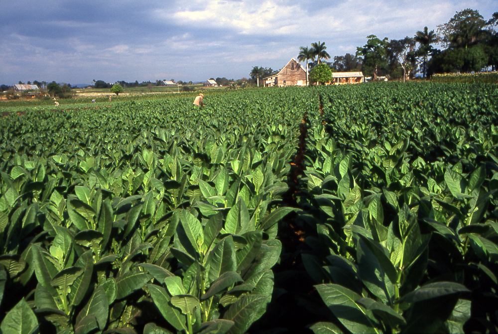
image_caption = Tobacco field in Pinar del Río Province
flag_size =
symbol =
symbol_size =
country = CUB
state =
region =
district =
capital =Pinar del Río
capital_type = Capital
capital_lat_d =
capital_lat_m =
capital_lat_s =
capital_lat_NS =
capital_long_d =
capital_long_m =
capital_long_s =
capital_long_E =
capital_elevation =
city_type =
city =
part_type =
part_count =
part =
part1 =
area = 10904.03
highest =
highest location =
highest_lat_d =
highest_lat_m =
highest_lat_s =
highest_lat_NS =
highest_long_d =
highest_long_m =
highest_long_s =
highest_long_EW =
highest_elevation =
lowest =
lowest_location =
lowest_lat_d =
lowest_lat_m =
lowest_lat_s =
lowest_lat_NS =
lowest_long_d =
lowest_long_m =
lowest_long_s =
lowest_long_EW =
lowest_elevation =
population_as_of = 2004
population_note =
population = 730626
population_density = 67
established_type =
established =
leader =
timezone = EST
utc_offset = -5
timezone_DST =
utc_offset_DST =
code_type = Area code
code = +53-82
code1_type =
code1 =
free_type =
free =
free1_type =
free1 =
map_size = 300
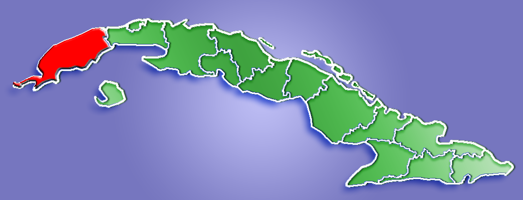
map_caption = Location of Pinar del Río Province inCuba
map_locator =
map_locator_x =
map_locator_y =
map_first = 1
website = [http://www.pinar.cu/ Pinar.cu]
footnotes =Pinar del Río is one of the
provinces of Cuba . It is at the western end of the island ofCuba .Geography
The Pinar del Río province contains one of Cuba's three main
mountain range s, theCordillera de Guaniguanico , divided into the easterlySierra del Rosario and the westerlySierra de los Organos . These form a landscape characterised by steep sidedlimestone hills (calledmogote s) and flat, fertilevalley s. Such a topographic feature, theViñales Valley , is aUNESCO World Heritage Site .The northern coast opens to the great
Gulf of Mexico , and is lined by theColorados Archipelago , a string ofcay s and isles developed on areef barrier. The western most point of Cuba, Cabo San Antonio is located on theGuanahacabibes Peninsula , which is aNational Park and aBiosphere Reserve .Economy
The province relies on
tobacco farming, with Pinar del Río producing 70% of Cuba's crop, used to make thecigar s that are so prized overseas. The best tobacco, used for more expensive cigar brands, is grown in the flat lands ofSan Juan y Martínez . Tourism in theViñales Valley is another important part of the economy.Municipalities
"Source: Population from 2004 Census."Cite web| url=http://www.atenas.inf.cu/todo/Estadisticas/TABLA%20No_3balance.htm| title=2004 Population trends, by Province and Municipality| author= Atenas.cu| year= 2004| accessdate=2007-10-06 Es icon] "Area from 1976 municipal re-distribution."Cite web|url=http://www.statoids.com/ycu.html|title=Municipios of Cuba|author=Statoids| year=2003| month=July| accessdate=2007-10-06 ]
Famous people from Pinar del Río
*
Omar Ajete - baseball player
*Danys Baez - baseball player
*Willy Chirino - singer/song-writer
*José Contreras - baseball player
*Silvia Costa - high jumper
*Emeterio González - javelin thrower
*Pedro Luis Lazo - baseball player
*Omar Linares - baseball player
*Alay Soler - baseball player
*Alejandro Robaina - famed tobacco grower
*Frank Delgado - singer/song-writerDemographics
In 2004, the province of Pinar Del Rio had a population of 730,626.Cite web| url=http://www.atenas.inf.cu/todo/Estadisticas/TABLA%20No_3balance.htm| title=2004 Population trends, by Province and Municipality| author= Atenas.cu| year= 2004| accessdate=2007-10-02 Es icon] With a total area of km2 to mi2|10904.03|abbr=yes|wiki=yes,Cite web| url=http://www.cubagob.cu/otras_info/censo/tablas_html/ii_4.htm| title=Population by Province| author= Government of Cuba| year= 2002| accessdate=2007-10-02 Es icon] the province had a population density of Pop density km2 to mi2|67.0|abbr=yes.
References
External links
* [http://www.pinar.cu/ Pinar.cu]
----
Wikimedia Foundation. 2010.