- Mathematical tile
-
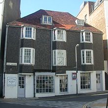
Black glazed mathematical tiles—as seen here at 44 Old Steine—are a characteristic feature of Brighton's 18th-century architecture.

Mathematical tiles are a building material used extensively in the southeastern counties of England—especially East Sussex and Kent—in the 18th and early 19th centuries.[1] They were laid on the exterior of timber-framed buildings as an alternative to brickwork, which their appearance closely resembled.[2] A distinctive black variety with a glazed surface was used on many buildings in Brighton (now part of the city of Brighton and Hove) from about 1760 onwards, and is considered a characteristic feature of the town's early architecture.[1][3] Mathematical tiles had an extra price advantage during the time of the brick tax (1784–1850), although later there was a tax on tiles also.
Contents
Usage and varieties
The tiles were laid in a partly overlapping pattern, akin to roof shingles. Their lower section—the part intended to be visible when the tiling was complete—was thicker; the upper section would slide under the overlapping tile above and would therefore be hidden. In the top corner was a hole for a nail to be inserted. They would then be hung on a lath of wood, and the lower sections would be moulded together with an infill of lime mortar to form a flat surface.[4] The interlocking visible surfaces would then resemble either header bond or stretcher bond brickwork.[1][2][5][6] Mathematical tiles had several advantages over brick: they were cheaper,[1] easier to lay than bricks (skilled workmen were not needed),[7] and were more resistant to the weathering effects of wind, rain and sea-spray, making them particularly useful at seaside locations such as Brighton.[8]
Various colours of tile were produced: red, to resemble brick most closely; honey; cream; and black. Brighton, the resort most closely associated with mathematical tiles, has examples of each. Many houses on the seafront east of the Royal Pavilion and Old Steine, for example on Wentworth Street, have cream-coloured tiles,[3] and honey-coloured tiles were used by Henry Holland in his design for the Marine Pavilion—forerunner of the Royal Pavilion.[7] Holland often used mathematical tiles in his commissions, although he usually used blue Gault clay to make them.[9]
Black glazed tiles
The black glazed type is most closely associated with the Brighton's early architecture:[1] such tiles had the extra advantage of reflecting light in a visually attractive way.[10] Black mathematical tiles started to appear in the 1760s, soon after the town began to grow in earnest as its reputation as a health resort became known.[11] When Patcham Place, a mid 16th-century house in nearby Patcham (now part of the city of Brighton and Hove), was rebuilt in 1764, it was clad entirely in the tiles.[12] Royal Crescent, Brighton's first unified architectural set piece and first residential development built to face the sea, was faced in the same material when it was built between 1799 and 1807.[13] When Pool Valley—the site where a winterbourne drained into the English Channel—was built over in the 1790s, one of the first buildings erected there was a mathematical tiled two-storey shop. Both the building (now known as 9 Pool Valley) and the façade survive.[14] All three of these have Grade II* listed status,[15] indicating that in the context of England's architecture they are "particularly important ... [and] of more than special interest".[16] Other examples can be seen at Grand Parade—the east side of Old Steine, developed haphazardly with large houses in a variety of styles and materials in the early 19th century;[17][18] York Place, a fashionable address when built in the 1800s;[19] and Market Street in The Lanes, Brighton's ancient core of narrow streets.[3]
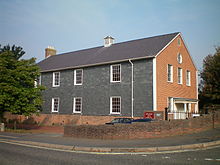
Lewes, the county town of East Sussex, also has many buildings with black mathematical tiles, including the Grade I-listed Jireh Chapel in the Cliffe area of the town. The timber-framed chapel was built in 1805.[20] Elsewhere, a study in 2005 identified 22 18th-century timber-framed buildings (mostly townhouses) with mathematical tiles of various colours.[21] Examples are the semi-detached pair at 199 and 200 High Street,[21] the small terrace at 9–11 Market Street, 33 School Hill (an old building with a mid-18th century renewed façade), and the Quaker meeting house of 1784.[22]
Examples from Brighton
-
Brick coloured mathematical tiles on a bay window in George Street Location on Google Maps
-
Terracotta coloured mathematical tiles on a bay window in Grand Parade Location on Google Maps
-
Cream coloured mathematical tiles on a building in Old Steine Location on Google Maps
-
Cream coloured mathematical tiles on houses in Marine Square Location on Google Maps
-
White and Terracotta coloured mathematical tiles on Grand Parade Location on Google Maps
-
Cream coloured mathematical tiles on an Amon Wilds house at 47 Grand Parade Location on Google Maps
-
Cream coloured mathematical tiles on an Amon Wilds house on St George's Place Location on Google Maps
-
Rare example of blue, cream, maroon and dark maroon mathematical tiles at the end of the terrace on the West of Portland Place.Location on Google Maps
-
Brick and Flint effect mathematical tiles on a building in Ship Street. (This image is composed of four individual photographs.) Location on Google Maps
-
Black mathematical tiles on houses with unusual offset bay windows on Grand Parade Location on Google Maps
-
Houses on Royal Crescent, Brighton are entirely faced with black mathematical tiles Location on Google Maps
-
44 Old Steine Location on Google Maps
-
Missing mathematical tile on St James's St showing the flange of its lower left neighbour used to attach it to the woodwork Location on Google Maps
External links
- Building materials in Brighton and Hove photos and diagrams
- Robus Ceramics - Mathematical tiles a modern supplier
References
Notes
- ^ a b c d e Antram & Morrice 2008, p. 6.
- ^ a b Nairn & Pevsner 1965, p. 661.
- ^ a b c Carder 1990, §4.
- ^ Berry 2005, p. 110.
- ^ Martin, Ron (22 March 2006). "Building materials in Brighton and Hove: Mathematical Tiles". My Brighton and Hove (c/o QueensPark Books). http://www.mybrightonandhove.org.uk/page_id__6738.aspx. Retrieved 9 February 2010.
- ^ Chitham, Robert (February 1987). "Conservation Bulletin, Issue 1, February 1987" (PDF). English Heritage. p. 4. http://www.english-heritage.org.uk/upload/pdf/Conservation_Bulletin_01.pdf?1261342202. Retrieved 9 February 2010.
- ^ a b Berry 2005, p. 103.
- ^ Brighton Polytechnic. School of Architecture and Interior Design 1987, p. 65.
- ^ Antram & Morrice 2008, p. 31.
- ^ Musgrave 1981, p. 125.
- ^ Carder 1990, §15.
- ^ Brighton Polytechnic. School of Architecture and Interior Design 1987, p. 111.
- ^ Antram & Morrice 2008, p. 133.
- ^ Carder 1990, §125.
- ^ "The Brighton and Hove Summary Lists of Historic Buildings (ENS/CR/LB/03)" (PDF). Brighton and Hove City Council Register of Listed Buildings. Brighton and Hove City Council. 16 October 2009. http://www.brighton-hove.gov.uk/downloads/bhcc/conservation/LB-03_B__H_Summary_Oct_09_Lists_of_Historic_Buildings_2009-10-16.pdf. Retrieved 7 February 2010.
- ^ "Listed Buildings". English Heritage. 2010. http://www.english-heritage.org.uk/caring/listing/listed-buildings/. Retrieved 26 August 2011.
- ^ Antram & Morrice 2008, p. 92.
- ^ Brighton Polytechnic. School of Architecture and Interior Design 1987, p. 43.
- ^ Antram & Morrice 2008, p. 92.
- ^ "Detailed Record: Jireh Chapel & Sunday School to north, Malling Street (east side), Lewes". Images of England. English Heritage. 2007. http://www.imagesofengland.org.uk/Details/Default.aspx?id=293297&mode=quick. Retrieved 7 February 2010.
- ^ a b Harris, Roland B. (March 2005). "Lewes Historic Character Assessment Report" (PDF). Sussex Extensive Urban Surveys (EUS). Lewes District Council in association with English Heritage. p. 42. http://www.lewes.gov.uk/Files/plan_Lewes_EUS_reportpg42to47.pdf. Retrieved 7 February 2010.
- ^ Harris, Roland B. (March 2005). "Lewes Historic Character Assessment Report" (PDF). Sussex Extensive Urban Surveys (EUS). Lewes District Council in association with English Heritage. p. 43. http://www.lewes.gov.uk/Files/plan_Lewes_EUS_reportpg42to47.pdf. Retrieved 7 February 2010.
Bibliography
- Antram, Nicholas; Morrice, Richard (2008). Brighton and Hove. Pevsner Architectural Guides. London: Yale University Press. ISBN 978-0-300-12661-7.
- Berry, Sue (2005). Georgian Brighton. Chichester. ISBN 1-86077-342-7.
- Brighton Polytechnic. School of Architecture and Interior Design (1987). A Guide to the Buildings of Brighton. Macclesfield: McMillan Martin. ISBN 1-869-86503-0.
- Carder, Timothy (1990). The Encyclopaedia of Brighton. Lewes: East Sussex County Libraries. ISBN 0-861-47315-9.
- Musgrave, Clifford (1981). Life in Brighton. Rochester: Rochester Press. ISBN 0-571-09285-3.
- Nairn, Ian; Pevsner, Nikolaus (1965). The Buildings of England: Sussex. Harmondsworth: Penguin Books. ISBN 0300096771.
Buildings and structures in Brighton and Hove Heritage Conservation areas · Listed buildings: Grade I · Grade II* · Grade II: A–B · C–D · E–H · I–L · M · N–O · P–R · S · T–V · W–Z


Places of worship List of places of worship (see list for links to individual articles) · List of demolished places of worship
Houses, flats
and mansionsChartwell Court · Embassy Court · Fife House · French Convalescent Home · 75 Holland Road · Marlborough House · New England Quarter · Ovingdean Rectory · Patcham Place · Pelham Institute · Preston Manor · Stanmer House · Sussex Heights · Van Alen Building · Western Pavilion
Crescents,
squares and
terracesAdelaide Crescent · Bedford Square · Belgrave Place · Bloomsbury Place · Brunswick Town · Hanover Crescent · Kemp Town · Lansdowne Square · Marine Square · Montpelier Crescent · New Steine · Norfolk Square · Norfolk Terrace · Old Steine · Oriental Place · Palmeira Square · Park Crescent · Pelham Square · Powis Square · Regency Square · Roundhill Crescent · Royal Crescent · Russell Square · Vernon Terrace · Wykeham Terrace
Commercial
buildingsAmex House · Brighton Forum, 95 Ditchling Road · Churchill Square · 20–22 Marlborough Place · 9 Pool Valley
Institutional and
civic buildingsBHASVIC · Brighton General Hospital · Brighton Town Hall · Hove Town Hall · Jubilee Library · Ovingdean Hall School · Royal Alexandra Hospital · Royal Sussex County Hospital · University of Sussex · Varndean College
Hotels and inns Hotels: Bedford · Grand (1984 bombing) · Metropole · Old Ship · Royal Albion · Royal York · Inns and pubs: The Cricketers · Evening Star · Freemasons Tavern · Hangleton Manor Inn · King and Queen · Royal Pavilion Tavern
Entertainment
and leisureAstoria (former) · Brighton Centre · Brighton Dome and Pavilion Theatre · Brighton Hippodrome (former) · Brighton Marina · Brighton Wheel · Duke of York's Picture House · Falmer Stadium · King Alfred Centre · Royal Pavilion · Saltdean Lido · Theatre Royal · Withdean Stadium · Museums: Booth Museum · Brighton Fishing Museum · Brighton Museum and Art Gallery · Brighton Toy and Model Museum · British Engineerium · Hove Museum and Art Gallery
Piers Brighton Pier · The Royal Suspension Chain Pier (demolished) · West Pier
Windmills Miscellaneous Barford Court · Chattri · Clock Tower · 11 Dyke Road · Foredown Tower · i360 (proposed) · Pepper Pot · St Dunstan's · Sassoon Mausoleum · Steine House (YMCA)
Related topics Ammonite Order · Bungaroosh · Cemeteries and crematoria · Mathematical tiles · Regency architecture · Architects: Charles Busby · John Leopold Denman · Thomas Lainson · John Nash · Basil Spence · Amon Henry Wilds · Amon Wilds
-
Wikimedia Foundation. 2010.


