- Mancunian Way
-
A57(M) motorway
Mancunian Way Route information Length: 2.0 mi (3.2 km) Existed: 1967 – present History: Additional slip roads completed in 1992 Major junctions From: Hulme To: Ardwick Location Primary
destinations:Manchester Road network Roads in the United Kingdom
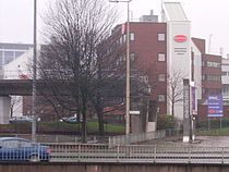
Motorways • A and B road zones A view of the Mancunian Way elevated motorway near UMIST.
The Mancunian Way, officially the A57(M), is a two mile long motorway in Manchester, England. It is part of the A57, which runs east-west through Greater Manchester and links the M602 and M67 motorways.
Contents
Route
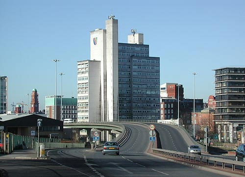
The road forms a major part of the Manchester-Salford Inner Ring Road and runs south of the city centre. Running eastbound, it starts as a 2 lane dual carriageway and passes underneath the A56. Following this, the road widens to 3 lanes. At the next junction which leads to the A5103, the road reduces to 2 lanes and becomes an elevated highway. This section runs atop link roads and two roundabouts before reaching the next junction with the A34. At this point the road passes through the centre of the campuses of UMIST (now part of the University of Manchester) and Manchester Metropolitan University. It then runs for around ¾ mile (1.2 km) before reaching its junction with the A6 which it crosses on a bridge before dropping down to ground level. It then finishes on the A635 and continues eastbound, and also continues to be called the Mancunian Way.
History
The Mancunian Way was conceived to form part of the South East Lancashire and North East Cheshire (SELNEC) Highway Plan of 1962, although similar proposals were developed from 1959.[1] A Parliamentary Bill to authorise the construction of the Mancunian Way was proposed and approved in 1961.
The construction was carried out in two phases: the first stage involved the construction of a dual carriageway of 950 yd to the east of the A6 road in November 1963 and was opened to traffic as part of the A636 road in November 1965. The second stage was the construction, from December 1964, of a 0.6 mi (1 km) long elevated highway of a motorway standard which ran between the A6 and A56 roads. The second stage was open to traffic as part of the A57 road in March 1967.
The Mancunian Way was officially opened by Prime Minister, Harold Wilson, on 5 May 1967. In the 1970s it was upgraded to motorway status as the A57(M) and the speed limit was raised to 50 miles per hour (80 km/h).[2] At the time of its opening the Manchester Evening News referred to it as the "highway in the sky".[3]
In 1992 the westbound junction was rebuilt to replace a temporary flyover, whereby the A56 passed over a roundabout where the A57(M) originally ended. At the same time a new flyover was built at the eastern end, over the A6, but was legally designated as the A635(M) in 1995.[4]
Oddities
Just before the junction with the A34 is an unfinished slip road (stub) that ends in mid-air, although it is hidden from the road by an advertising billboard. This was intended to be part of a dual carriageway into the city centre;[5] this plan was later abandoned.[6]
The last ½ mile (0.80 km) of the Mancunian Way in the east is part of the A635, the A57 heading south east from the same junction as the A6, though it states A57(M) on the signage as you enter westbound. Department for Transport documentation states differently,[7] so officially the Mancunian Way consists of two motorways, the A57(M) and the A635(M).
Cultural references
- The road is referenced in the BBC television drama Life On Mars. The central character, Sam Tyler, is knocked down by a car and "awakens" in 1973. The accident occurs by the Mancunian Way, and when he awakens, he does so on wasteland, with a nearby billboard advertising the planned "Highway in the Sky". Of course, the road was long completed by 1973.
- The 2006 Take That album Beautiful World includes a track entitled "Mancunian Way", which concerns the subject of Manchester generally.
Junctions
- Note: motorway has no junction numbers
 Ramp stub off the Mancunian Way at the junction with the A34
A57(M) and A635(M) motorways Eastbound exits Junction Westbound exits Road continues as A635 to Ashton-under-Lyne, Mossley and Greenfield Manchester Piccadilly, Stockport, Hyde A6
Sheffield (A57)Manchester Piccadilly, Stockport, Hyde A6
Sheffield (A57)Start of Motorway UMIST, Wilmslow, Cheadle, A34 No Exit No exit Didsbury, Birmingham, Manchester Airport, Chester, A5103 Didsbury, Birmingham, Manchester Airport, Chester A5103 No exit Start of Motorway Stretford, Sale, Castlefield, Manchester Central Convention Complex A56 Stretford, Sale, Castlefield, Manchester Central A56 Road continues as A57 to Salford and M602 See also
References
- ^ "A57(M)/A635(M) Mancunian Way". The Motorway Archive. http://www.iht.org/motorway/a57mancunian.htm. Retrieved 2009-08-28.
- ^ Rural Roads Old Maps Page - This page shows a selection of maps that show the road as A class when opened and later on as a motorway.
- ^ Manchester Evening News, Manchester Online - Eyewitness in Manchester Newsletter
- ^ Department for Transport (1995-12-14). Statutory Instrument 1995 No. 3266. http://www.opsi.gov.uk/si/si1995/Uksi_19953266_en_1.htm. Retrieved 2009-08-28.
- ^ Manchester Evening News, Manchester Online - Eyewitness in Manchester Newsletter Photo & Description
- ^ CBRD Motorway Database - A57(M)
- ^ Statutory Instrument 1995 No. 3266
Further reading
"The Mancunian Way - Manchester's Prestressed Concrete Elevated Roadway". Concrete Qarterly (72) January–March 1967. (Detailed construction information).
External links
- CBRD Motorway Database - A57(M)
- CBRD Videos M602 / A57(M)
- Manchester Evening News, Manchester Online - Eyewitness in Manchester Newsletter, including pictures
- Pathetic Motorways - A57(M)
- The Motorway Archive - A57(M)
Motorways in the United Kingdom Great Britain
(England, Scotland, Wales)Northern Ireland former unbuilt Transport in Greater Manchester Transport for Greater Manchester • Museum of Transport • Readycard Air Bus Arriva North West • Bluebird • Bullocks • Checkmate • Finglands • First Manchester • GM Buses • Jim Stones Coaches • JPT • Maytree Travel • Metroshuttle • Rossendale Transport • Speedwellbus • Stagecoach Manchester • South Lancs Travel • Stotts • Warrington Borough Transport • List of bus routes in Greater ManchesterRoad Tram Manchester Metrolink • Greater Manchester Metrolink LimitedRail TIF bid Congestion charging in Greater Manchester • Greater Manchester Transport Innovation Fund • United CitySee also: Transport in Manchester Categories:- Motorways in England
- Transport in Greater Manchester
- Transport in Manchester
- Buildings and structures in Manchester
- History of Manchester

Wikimedia Foundation. 2010.