- Dutch annexation of German territory after World War II
-
At the end of World War II, plans were made in the Netherlands to annex German territory as compensation for the damages caused by the war. In October 1945, the Dutch state asked Germany for 25 billion guilders in reparations, but in February 1945 it had already been established at the Yalta Conference that reparations would not be given in monetary form. The plan which was worked out in most detail was the one made by Frits Bakker-Schut, and hence became known as the Bakker-Schut Plan.
In its most ambitious form, this plan included the cities of Cologne, Aachen, Münster and Osnabrück, and would have enlarged the country by 30 to 50 percent. The local population had to be either deported, or, when still speaking the original Low German dialects, Dutchified. The plan was largely dropped after U.S. dismissal of it. Eventually, an area of a total size of 69 km2 was allocated to the Netherlands. Almost all of this was returned to West Germany in 1963 after Germany paid the Netherlands 280 million German marks.
Many Germans living in the Netherlands were however declared 'enemy subjects' after World War II ended and put into a concentration camp in an operation called Black Tulip. A total of 3,691 Germans were ultimately deported. The UK responded by expelling 100,000 Dutch citizens living in occupied Germany.
Contents
Liberation
In the first year following the liberation of the Netherlands in May 1945, dozens of pamphlets and brochures were published that propagated annexation of territory of the former German Reich, preferably without the accompanying German population. Several highly-placed persons, including then Foreign Minister Eelco Nicolaas van Kleffens, put forth their own ideas regarding annexation in these publications. Opinions varied widely as to how much territory should be annexed. Some people only wanted a few border corrections, others drew the new border past Hamburg.
The proponents of annexation joined in several local committees. On June 19, 1945, the Hague committee to examine the question of Dutch territorial expansion was founded. During a meeting of this committee on July 12, 1945, it was decided to split the committee in the Study Group Territorial Expansion (Studiegroep Gebiedsuitbreiding), chaired by Ph.J. Idenburg, and the Action Committee (Comité van Actie), which had as its primary function the education of the Dutch population about the expansion plans. Six days later, the latter committee was renamed the Dutch Committee for Territorial Expansion. It was chaired by former Finance minister Johannes van den Broek. On August 25, 1945, Minister Van Kleffens founded the State Commission for the Study of the Annexation Question, which was charged with writing a final report regarding the annexation question by May 1946.
The Study Group Territorial Expansion set up many groups that reported about their findings. The final judgment of the State Commission would be largely based on the results of this study group. The Dutch Committee for Territorial Expansion published on the progress of the study group by giving out brochures and giving lectures. The annexation question however led to intense discussions, which lead certain groups to go their own way and among other things found the Annexation Committee of the Foundation for Agriculture.
Bakker Schut Plan
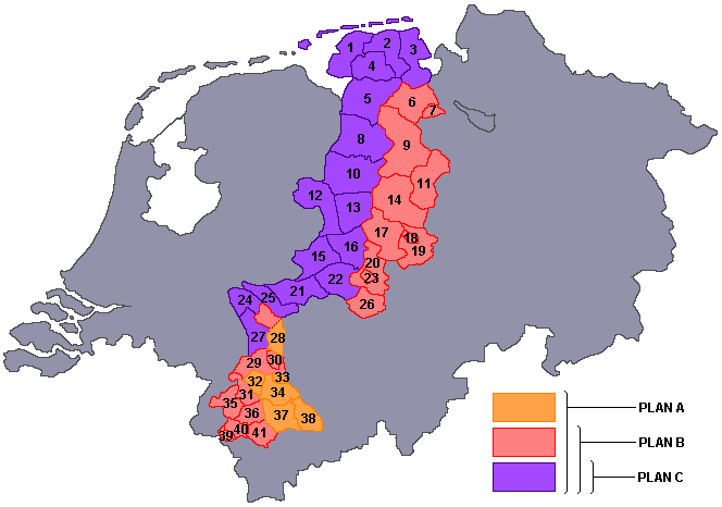
Bakker Schut was the president of the National service for the National Plan, secretary of the Dutch Committee for Territorial Expansion, and a member of the State Commission for the Study of the Annexation Question and of the Study Group Territorial Expansion. In his expansion plan, he suggested to annex a large part of northwestern Germany. All the land west of the line Wilhelmshaven-Osnabrück-Hamm-Wesel would be added to the Netherlands, as well as the land east of Limburg, where the border followed the Rhine until close to Cologne, then diverging towards Aachen in the west. In this A Variation of the plan, among others the large cities of Aachen, Cologne, Münster, Oldenburg and Osnabrück were annexed. Bakker Schut called this the Weser border and ended his writings with the slogan Nederland's grens kome aan de Wezer (The border of the Netherlands be at the Weser). In a smaller plan B, the west-Rhineland cities Cologne, Mönchengladbach and Neuss were not annexed. In a third option, plan C, the proposed annexation was much smaller. It included an area west of Varel, the entire Emsland, and the area around Wesel until near the Duchy of Cleves.
Areas to be annexed
 The Bakker-Schut Plan. To the left is the Netherlands, to the right is the part of Germany known as Lower Saxony and North Rhine-Westphalia. The coloured areas in the middle are the parts proposed for annexation by the Netherlands.
The areas which were to be annexed according to the Bakker Schut Plan were the following then existing districts and cities.
Nr Name A B C 01 Norden-Emden X X X 02 Wittmund X X X 03 Jever-Varel X X X 04 Aurich X X X 05 Weener-Leer X X X 06 Ammerland X X 07 Oldenburg-Stadt X X 08 Aschendorf-Hümmling X X X 09 Cloppenburg-Friesoythe X X 10 Meppen X X X 11 Vechta X X 12 Grafschaft Bentheim X X X 13 Lingen X X X 14 Bersenbrück X X 15 Ahaus X X X 16 Steinfurt X X X 17 Tecklenburg X X 18 Osnabrück Stadt X X 19 Osnabrück Land X X 20 Münsterland X X 21 Borken X X X 22 Coesfeld X X X 23 Münster Stadt X X 24 Kleve X X X 25 Rees X X X 26 Lüdinghausen X X 27 Geldern X X X 28 Moers X X 29 Kempen-Krefeld X X 30 Krefeld-Uerdingen X X 31 Erkelenz X X 32 Mönchengladbach X 33 Neuss X 34 Grevenbroich X 35 Heinsberg-Geilenkirchen X X 36 Julich X X 37 Bergheim X 38 Köln X 39 Aachen Stadt X X 40 Aachen Land X X 41 Düren X X Motivation
Although parts of the territory to be claimed (amongst others the Duchy of Cleves, the Duchy of Jülich and Bentheim) used to be Dutch speaking until being Germanized under Prussian hegemony,[citation needed] and the Dutch language and culture had a large influence in East Frisia, Bakker Schut was aware that it was difficult to claim this area purely on historical grounds. Hence, he justified the annexation using arguments like increased power and greater security for the Dutch state. He furthermore considered the annexation as compensation for war damages and as a part of the population policy to be followed. Contrary to what might be expected, after an inventory he considered the natural resources of the territory to be annexed as insufficiently important to motivate annexation. In his view, even a transfer of the entire Ruhr Area would not be sufficient to pay for the damages.
Forced migration
A big point of discussion in Bakker Schut's expansion plan was the proposed forced migration of the original German population. Millions of Germans would have to be transferred to the remaining German territories, because it was feared that increasing the Dutch population from 9 to 11 million people could cause trouble in providing everybody with food. A pamphlet titled Oostland - Ons Land (East land - Our land) contained a complete schedule for the extradition of the population, starting with all inhabitants of municipalities with a population of at least 2,500, all former members of the NSDAP and related organizations, and all inhabitants who had settled in the area after 1933. In special cases, the inhabitants could request to be naturalized, for instance if they had made efforts for the Dutch state during the war, if they usually spoke Low Saxon instead of High German, if they had no family members up to the second degree that lived in Germany, or if they wished to become Dutch.
Dutch names
It was also already determined which Dutch names the cities and areas in the territory to be annexed would get. For most if not all cities, an old Dutch equivalent was already available. The table below gives a small sample of the suggested name changes.
Suggested names Original German names Aken Aachen Emmelkamp Emlichheim Emmerik Emmerich Geelkerken Geilenkirchen Gelderen Geldern Gogh Goch Gulik Jülich Hoog Elten Hoch-Elten Jemmingen Jemgum Kleef Kleve Keulen Köln Meurs Moers Monniken-Glaabbeek Mönchengladbach Munster Münster Neder-Benthem Bad Bentheim Nieuwenhuis Neuenhaus Noordhoorn Nordhorn Osnabrugge Osnabrück Veldhuizen Veldhausen Wezel Wesel Zelfkant Selfkant Zwilbroek Zwillbrock Dispute
In the Dutch cabinet, a dispute about the annexation question arose. Van Kleffens promoted territorial expansion, while Minister of Social Affairs Willem Drees (later Prime Minister) was dead set against it. Generally, socialists were against annexation and Protestants and liberals were reluctant. The Catholics saw advantages in the territorial expansion, mainly as a method to give the farmers near the border more room. Nevertheless, Dutch churches objected to the proposed mass extradition, because in their eyes the German population could not be found guilty of the crimes of the Nazis during World War II. Prime Minister Wim Schermerhorn was also not in favor of annexing German territory, but Queen Wilhelmina, an energetic supporter of the annexation plan, strongly urged him to start negotiating on this with the Allies. In 1946, in the name of the Dutch government, he officially claimed 4,980 km2 of German territory, which was not even half of the area envisioned by Van Kleffens. The Dutch-German border would be drawn from Vaals via Winterswijk to the Ems River, so that 550,000 Germans would live inside the Dutch national borders.
Implementation
The large scale annexation was in 1947 rejected by the Allied High Commission, on the grounds that Germany already contained 14,000,000 refugees from the annexations in the east, and that the remaining territory could not handle more refugees. Furthermore, the allies (in particular the Americans) considered it vital to have a stable West-Germany in view of the coming Cold War. All suggested annexations of the Morgenthau Plan were ignored as a result of new political developments.
At a conference of foreign ministers of the western allied occupation forces in London (January 14 until February 25, 1947), the Dutch government (Cabinet Beel I) claimed an area of 1,840 km2. This claim included apart from the island Borkum large parts of the Emsland, Bentheim, the cities Ahaus, Rees, Kleve, Erkelenz, Geilenkirchen and Heinsberg and the areas around these cities.
In 1946, about 160,000 people lived in this area, of which more than 90% spoke German. This plan was a very simplified version of the C-variation of the Bakker Schut Plan. The KVP considered this proposal much too small, while the CPN rejected any kind of reparations in the form of territorial expansion.
The London conference of April 23, 1949, only permitted some less far-reaching border modifications. At 12 o'clock of the very same day, Dutch troops occupied an area of 69 km2, the largest parts of which were Elten (near Emmerich am Rhein) and Selfkant. Many other small border corrections were executed, mostly in the vicinity of Arnhem and Dinxperlo. At that time, these areas were inhabited by a total of almost 10,000 people.
Overview of areas annexed in 1949 (from north to south)
- Uninhabited areas (0.3 km2) between Nieuweschans and Ter Apel
- Uninhabited areas on both sides of the Channel Almelo-Nordhorn (0.3 km2)
- Area near Losser, 18 inhabitants (1 km2)
- Small border road near Rekken south of Haaksbergen
- Uninhabited area near Kotten (0.09 km2)
- Suderwick, small village bordering on Dinxperlo, 342 inhabitants (0.64 km2)
- Elten, small town on the Rhine, 3,235 inhabitants (19,54 km2)
- Small border road near Millingen aan de Rijn
- Duivelsberg between Beek and Wijlerberg
- Border road near Mook;
- Uninhabited area near Ottersum (0,05 km²);
- Border road near Siebengewald, four inhabitants;
- Two areas north and south of Arcen, sixty inhabitants (0.4 and 0.41 km²)
- Area near Sittard of 41,34 km² inhabited by 5,665 people (Selfkant);
- Border road near Ubach over Worms;
- Area near Rimburg and Kerkrade, 130 inhabitants (0.88 km²);
- Fixed some border-technical mistakes in Kerkrade
- Area near Eijgelshoven, 110 inhabitants (0,11 km²)
Return
Starting in March 1957, West Germany negotiated the return of these areas with the Netherlands. These negotiations led to an agreement (German: Vertrag vom 8. April 1960 zwischen der Bundesrepublik Deutschland und dem Königreich der Niederlande zur Regelung von Grenzfragen und anderen zwischen beiden Ländern bestehenden Problemen; short: Ausgleichsvertrag, i.e. treaty of settlement)[1] made in The Hague on April 8, 1960, in which Germany agreed to pay 280 million German marks for the return of Elten, Selfkant, and Suderwick, as Wiedergutmachung.
The territory was returned to Germany on August 1, 1963, except one small hill (about 3 km²) near Wyler village, called Duivelsberg/Wylerberg (link to Dutch wikipedia) which was annexed by Netherlands.
See also
- German reparations for World War II
- Morgenthau Plan
- Monnet Plan
- Marshall Plan
External links
- Interview with Perry Laukhuff, secretary of mission with U.S. Political Adviser for Germany, Berlin, 1945-49 Describes how amongst other nations the Netherlands tried to grab German territory in 1949
- 'Eisch Duitschen grond!' Comprehensive overview, in Dutch.
- International Boundary Study No. 31 – April 6, 1964 Germany – Netherlands Boundary. The Geographer Office of the Geographer Bureau of Intelligence and Research (MAP})
Notes
- ^ Cf. Bundesgesetzblatt (federal law gazette), part III, no. 181-1.
Categories:- Germany–Netherlands relations
- Anti-German sentiment
- Aftermath of World War II
- 20th century in Germany
- Military history of the Netherlands during World War II
- 20th century in economics
- Allied occupation of Germany
Wikimedia Foundation. 2010.