- Losser
Infobox Settlement
official_name = Losser
mapsize = 280px
subdivision_type = Country
subdivision_name =Netherlands
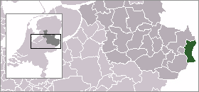
subdivision_type1 = Province
subdivision_name1 =Overijssel
area_footnotes = (2006)
area_total_km2 = 99.64
area_land_km2 = 98.95
area_water_km2 = 0.69
population_as_of =1 January ,2007
population_note = Source: CBS, [http://statline.cbs.nl/ Statline] .
settlement_type = Municipality
population_total = 22479
population_density_km2 = 227
timezone = CET
utc_offset = +1
timezone_DST = CEST
utc_offset_DST = +2.Population centres
*Beuningen
*De Lutte
*Glane
*Losser
*Overdinkel Losser
The oldest known reference to Losser dates from the tenth century Stenvert, R. et al. (1998). "Monumenten in Nederland: Overijssel", p. 213–215, 240. Zwolle: Waanders Uitgevers. ISBN 90-400-9200-1.] . Originally, the village consisted of two separate parts. Both were almost completely destroyed when on
September 21 ,1665 , troops fromMünster set fire to themBuisman, J. (2000). "Duizend jaar weer, wind en water in de lage landen: 1575–1675", p. 597. Franeker: Van Wijnen. ISBN 90-5194-136-6.] .One of the town's oldest buildings is the Martinitoren (St. Martin's Tower), dating from around 1500 and the only remaining part of a church demolished in 1903.
Geography
A few kilometers west of De Lutte, close to the border with
Oldenzaal , lies the Tankenberg, a hill the top of which (85 m) is the highest point in the province. (For myths of the Tankenberg, seeTanfana .)The municipality's most important body of water is the river
Dinkel .References
External links
* [http://www.gemeentelosser.nl Official website]
* [http://www.losser-digitaal.nl Digital Losser]
* [http://www.beleeflosser.nl Losser Tourists]----

Wikimedia Foundation. 2010.