- Dugi otok
-
Dugi otok 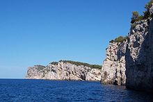
Western shore of Dugi otok
Geography Location Adriatic Sea Coordinates 44°01′N 15°01′E / 44.017°N 15.017°E Area 114.44 km2 (44.186 sq mi) Highest elevation 300 m (1,000 ft) Country CroatiaCounty Zadar Largest city Sali Demographics Population 1,772 (as of 2001[1]) Dugi otok (pronounced [dûgiː ɔ̌tɔk]; Croatian for “Long Island”, Italian: Isola Lunga) is the seventh largest island in the Adriatic Sea, part of Croatia. It is located off the Dalmatian coast, west of Zadar. It is the largest and eastern-most of the Zadarian Islands, and derives its name from its distinctive shape (it is 45 km long by 5 km wide with an area of 114 km2). Its elevation reaches 300 m; and many of its higher portions contain stands of Maritime Pine.
The western coast is tall and rugged, and many of the towns are clustered on the eastern side, including Sali, the largest, Božava, Dragove, Soline, Brbinj, Luka, Polje, Verona, Savar, Veli Rat, Zaglav, and Žman. A nature park, Telašćica, covers the southern part of the island and is adjacent to Kornati Islands National Park.
Contents
History
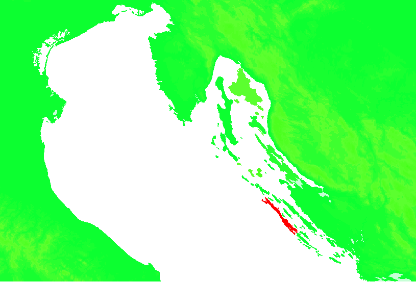
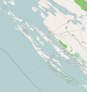 Map. The longest island is Dugi otok
The island has been inhabited since prehistoric times. The Byzantine Emperor Constantine VII in the 10th century mentioned it under the name of Pizuh, and later it was called Insula Tilagus in documents ("pelagos"in Greek means sea), and its Latin name was Insula maior. In the 15th century it was registered as Veli otok.
The old and main settlement on the island was located in the southern area. It has only been inhabited significantly since the Turkish invasions (15th-16th centuries). Until then the island belonged to Zadar monasteries and citizens.[2] Nowadays there is a total of 10 settlements on the island, and they are all on the north-eastern side of the island concerned primarily with fishing, although salt was once produced here.
The village of Veli Rat is also home to the Veli Rat lighthouse, another spectacular sight. The beautiful island of Dugi otok, with a Mediterranean climate and ancient Croatian culture, receives very few visitors. Olive oil, figs, cheese and wine accompany the seafood in the natives' diet. A definite step back in time, the island boasts an ancient pre-Roman church and some Roman ruins. It is in close proximity to Kornati.
Description
 The salt lake.
More than 1500 hectares are covered with vineyards, orchards and arable land, about 752 hectares are pasture land and about 300 hectares undergrowth which in some places is used as a forest land. The vegetation is more pronounced in the northern and central areas of the island. The south-eastern part belong to the Kornati.
See also
References
- ^ "Statistical Yearbook" (PDF). Central Bureau of Statistics of the Republic of Croatia. 2003. http://www.dzs.hr/Hrv_Eng/ljetopis/2003/tabele/01_042_tab.pdf. Retrieved 2010-09-18. "Inhabited islands of Croatian part of the Adriatic Sea"
- ^ Naklada Naprijed, The Croatian Adriatic Tourist Guide, pg. 190, Zagreb (1999), ISBN 953-178-097-8
Adriatic islands of Croatia > 100 km2 10–100 km2 1–10 km2 Arta Velika · Biševo · Dolin · Drvenik Mali · Goli otok · Ilovik · Ist · Jakljan · Kakan · Kaprije · Katina · Koločep · Kurba Vela · Lavdara · Lavsa · Levrnaka · Lopud · Mali Brijun · Maun · Mrčara · Piškera · Planik · Plavnik · Premuda · Prežba · Prvić (Šibenik) · Rava · Rivanj · Šćedro · Sit · Smokvica Vela (Kornat) · Škarda · Škrda · Sušac · Susak · Svetac · Sveti Grgur · Sveti Klement · Tijat · Tun Veli · Vele Orjule · Vele Srakane · Veliki Brijun · Vrgada · Zeča · Zlarin · Zmajan · ZverinacInhabited islands of Croatia Biševo • Brač • Čiovo • Cres • Drvenik Mali • Drvenik Veliki • Dugi otok • Hvar • Ilovik • Ist • Iž • Kaprije • Koločep • Kornat • Korčula • Krapanj • Krk • Lastovo • Lopud • Lošinj • Male Srakane • Mljet • Molat • Murter • Olib • Ošljak • Pag • Pašman • Premuda • Prvić • Rab • Rava • Rivanj • Sestrunj • Silba • Šipan • Šolta • Susak • Ugljan • Unije • Vele Srakane • Vir • Vis • Vrgada • Žirje • Zlarin • ZverinacCategories:- Islands of Croatia
- Islands of the Adriatic Sea
- Zadar County


Wikimedia Foundation. 2010.