- Santarém District
-
District of Santarém — District — 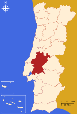
Country Portugal Region Centro
and AlentejoHistorical province Ribatejo
(partly Beira Baixa
and Beira Litoral)No. of municipalities 21 No. of parishes 193 Capital Santarém Area – Total 6.747 km2 (2.6 sq mi) Population – Total 475.344 – Density 70.5/km2 (182.5/sq mi) No. of parliamentary representatives 10 The District of Santarém (Portuguese pronunciation: [sɐ̃tɐˈɾɐ̃j], Portuguese: Distrito de Santarém) is located in Centro Region, Portugal, the district capital is the city of Santarém.
It has an area of 6747 km² (3rd largest in Portugal), and a population of 475,344 inhabitants.
Municipalities
The district includes the following 21 municipalities.
- Abrantes Municipality
- Alcanena Municipality
- Almeirim Municipality
- Alpiarça Municipality
- Benavente Municipality
- Cartaxo Municipality
- Chamusca Municipality
- Constância Municipality
- Coruche Municipality
- Entroncamento Municipality
- Ferreira do Zêzere Municipality
- Golegã Municipality
- Mação Municipality
- Ourém Municipality
- Rio Maior Municipality
- Salvaterra de Magos Municipality
- Santarém Municipality
- Sardoal Municipality
- Tomar Municipality
- Torres Novas Municipality
- Vila Nova da Barquinha Municipality

Districts and Autonomous regions of Portugal Districts 
Autonomous regions Coordinates: 39°14′N 8°41′W / 39.233°N 8.683°W
Categories:- Districts of Portugal
- Portugal geography stubs

Wikimedia Foundation. 2010.