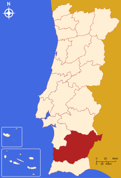
- Beja District
-
For other uses, see Beja (disambiguation).
District of Beja — District — Country Portugal Region Alentejo Historical province Baixo Alentejo No. of municipalities 14 No. of parishes 100 Capital Beja Area – Total 10.225 km2 (3.9 sq mi) Population – Total 161.211 – Density 15.8/km2 (40.8/sq mi) No. of parliamentary representatives 3 The Beja District (Portuguese pronunciation: [ˈbɛʒɐ]) is located in southern Portugal. The district capital is the city of Beja.
Municipalities
The district is composed of 14 municipalities:
- Aljustrel
- Almodôvar
- Alvito
- Barrancos
- Beja
- Castro Verde
- Cuba
- Ferreira do Alentejo
- Mértola
- Moura
- Odemira
- Ourique
- Serpa
- Vidigueira
Summary of votes and seats won 1976-2009
Summary of election results from Beja district, 1976-2009 Parties % S % S % S % S % S % S % S % S % S % S % S % S % S 1976 1979 1980 1983 1985 1987 1991 1995 1999 2002 2005 2009 2011 PS 32.0 2 22.0 1 21.1 1 28.0 2 20.1 1 20.3 1 28.4 1 45.8 2 46.7 2 43.5 2 51.0 2 34.9 2 29.8 1 PSD 8.2 11.8 13.7 1 24.5 1 29.3 1 15.7 1 14.5 21.2 12.3 14.6 23.7 1 CDS-PP 4.2 4.1 2.2 2.0 2.3 3.6 3.9 3.7 2.9 5.7 7.3 PCP/APU/CDU 44.0 4 50.7 3 47.1 3 49.4 3 44.9 3 38.7 3 30.4 2 29.2 1 28.3 1 24.2 1 24.1 1 29.1 1 25.4 1 BE 1.6 1.9 4.7 10.0 5.2 AD 19.0 1 22.4 1 PRD 11.6 5.7 Source: Comissão Nacional de Eleições External links

Districts and Autonomous regions of Portugal Districts 
Autonomous regions Coordinates: 38°01′N 7°52′W / 38.017°N 7.867°W
Categories:- Beja District
- Districts of Portugal
- Alentejo
- Portugal geography stubs
Wikimedia Foundation. 2010.

