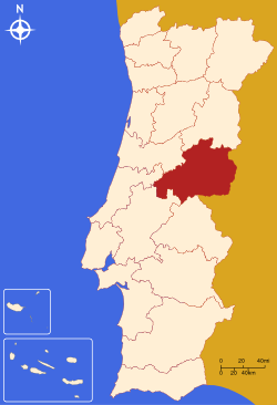
- Castelo Branco District
-
District of Castelo Branco — District — Country Portugal Region Centro Historical province Beira Baixa No. of municipalities 12 No. of parishes 160 Capital Castelo Branco Area – Total 6.675 km2 (2.6 sq mi) Population – Total 208,070 – Density 31,171.5/km2 (80,733.9/sq mi) No. of parliamentary representatives 4 Castelo Branco District (Portuguese pronunciation: [kɐʃˈtɛlu ˈβɾɐ̃ku], Portuguese: Distrito de Castelo Branco) is located in Central Portugal, the district capital is Castelo Branco, which is now also the most populous city, although the city of Covilhã was once the largest city.
It has an area of 6675 km² (4th largest in Portugal), and a population of 208,069 inhabitants.
Municipalities
The district is composed of 11 municipalities:
- Belmonte
- Castelo Branco
- Covilhã
- Fundão
- Idanha-a-Nova
- Oleiros
- Penamacor
- Proença-a-Nova
- Sertã
- Vila de Rei
- Vila Velha de Ródão
Summary of votes and seats won 1976-2011
Summary of election results from Castelo Branco district, 1976-2011 Parties % S % S % S % S % S % S % S % S % S % S % S % S % S 1976 1979 1980 1983 1985 1987 1991 1995 1999 2002 2005 2009 2011 PS 36.4 3 27.8 2 30.3 2 37.1 3 18.5 1 22.4 2 32.4 2 53.2 3 51.6 3 46.1 3 56.0 4 41.0 2 34.8 2 PSD 22.6 2 30.6 2 31.2 3 52.1 4 51.8 3 32.1 2 32.0 2 38.3 2 26.7 1 29.8 2 37.9 2 CDS-PP 19.9 2 13.2 1 9.6 4.7 3.9 7.2 6.3 7.1 5.3 8.4 9.6 PCP/APU/CDU 6.6 12.4 10.5 11.3 8.9 7.1 4.6 3.5 5.3 3.3 3.8 5.1 4.9 BE 1.2 1.5 3.7 9.1 4.2 AD 49.9 4 51.0 4 PRD 24.4 2 6.0 Source: Comissão Nacional de Eleições 
Districts and Autonomous regions of Portugal Districts 
Autonomous regions Categories:- Districts of Portugal
- Portugal geography stubs
Wikimedia Foundation. 2010.

