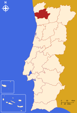
- Braga District
-
Braga — District — Country Portugal Region Norte Historical province Minho No. of municipalities 14 No. of parishes 515 Capital Braga Area – Total 2,673 km2 (1,032.1 sq mi) Population – Total 831,368 – Density 311/km2 (805.5/sq mi) No. of parliamentary representatives 19 The district of Braga (Portuguese pronunciation: [ˈbɾaɣɐ], Portuguese: Distrito de Braga) is a district in the northwest of Portugal. The district capital is the city of Braga, and it is bordered by the district of Viana do Castelo in the north, Vila Real in the east, and Porto in the south. Its area is 2,673 km² and it has a population of 831,368.
Municipalities
The district comprises 14 municipalities:
- Amares
- Barcelos
- Braga
- Cabeceiras de Basto
- Celorico de Basto
- Esposende
- Fafe
- Guimarães
- Póvoa de Lanhoso
- Terras de Bouro
- Vieira do Minho
- Vila Nova de Famalicão
- Vila Verde
- Vizela
Summary of votes and seats won 1976-2011
Summary of election results from Braga district, 1976-2011 Parties % S % S % S % S % S % S % S % S % S % S % S % S % S 1976 1979 1980 1983 1985 1987 1991 1995 1999 2002 2005 2009 2011 PS 32.3 6 30.2 5 29.3 5 39.7 7 21.8 4 25.9 5 31.5 5 42.9 8 44.3 8 37.4 8 45.4 9 41.7 9 32.9 7 PSD 28.6 5 27.0 5 32.8 6 53.4 10 53.6 10 38.2 7 36.7 7 44.4 9 32.9 7 30.8 6 40.1 9 CDS-PP 25.2 4 18.3 3 14.0 2 5.9 1 5.6 1 10.7 1 8.9 1 9.3 1 7.8 1 9.7 2 10.4 2 PCP/APU/CDU 4.2 10.0 1 8.4 1 8.8 1 8.5 1 6.1 1 4.6 4.5 5.4 1 4.4 4.8 1 4.6 1 4.9 1 BE 1.2 1.7 4.6 7.8 1 4.2 AD 51.9 9 54.9 9 PRD 16.8 3 3.3 Source: Comissão Nacional de Eleições External links

Districts and Autonomous regions of Portugal Districts 
Autonomous regions Categories:- Braga District
- Braga geography stubs
Wikimedia Foundation. 2010.

