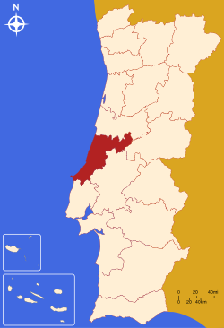
- Leiria District
-
District of Leiria — District — Country Portugal Region Centro Historical province Beira Litoral
and EstremaduraNo. of municipalities 16 No. of parishes 148 Capital Leiria Area – Total 3.515 km2 (1.4 sq mi) Population – Total 459.450 – Density 130.7/km2 (338.5/sq mi) No. of parliamentary representatives 10 The District of Leiria (Portuguese pronunciation: [lɐjˈɾi.ɐ], Portuguese: Distrito de Leiria) is located in Central Portugal. The District Capital is the city of Leiria which is also the largest city and most populous city. The district is composed by 16 municipalities: [C = city/cidade T = town/vila]
- Alcobaça C
- Alvaiázere T
- Ansião T
- Batalha T
- Bombarral T
- Caldas da Rainha C
- Castanheira de Pêra T
- Figueiró dos Vinhos T
- Leiria C
- Marinha Grande C
- Nazaré T
- Óbidos T
- Pedrógão Grande T
- Peniche C
- Pombal C
- Porto de Mós T
Summary of votes and seats won 1976-2011
Summary of election results from Leiria district, 1976-2011 Parties % S % S % S % S % S % S % S % S % S % S % S % S % S 1976 1979 1980 1983 1985 1987 1991 1995 1999 2002 2005 2009 2011 PS 31.1 4 23.2 3 22.7 3 32.7 4 19.6 2 18.7 2 23.0 3 36.7 4 36.8 4 29.5 3 35.6 4 30.1 4 20.7 3 PSD 31.2 4 35.6 4 38.6 5 60.8 9 61.2 7 43.3 5 42.6 5 50.8 6 39.8 5 34.9 4 47.0 6 CDS-PP 19.4 2 16.2 2 12.2 1 6.0 4.8 11.4 1 9.9 1 9.8 1 8.9 1 12.6 1 12.8 1 PCP/APU/CDU 7.3 1 10.9 1 9.7 1 9.5 1 7.9 1 5.9 4.5 4.5 5.3 4.1 4.6 5.1 5.0 BE 1.7 2.2 5.5 9.5 1 5.1 AD 56.2 7 59.8 7 PRD 15.3 2 3.0 Source: Comissão Nacional de Eleições 
Districts and Autonomous regions of Portugal Districts 
Autonomous regions Categories:- Districts of Portugal
- Leiria District
- Portugal geography stubs
Wikimedia Foundation. 2010.

